This copy is copyright protected.
Copyright © 2025 Geographicus Rare Antique Maps
Digital Image: 1876 Carter Map of New Hampshire Election Districts
NewHampshireDistricts-carter-1876_d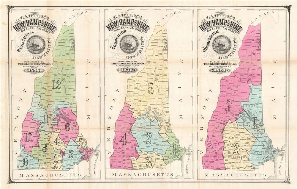

FOR THE ORIGINAL ANTIQUE MAP, WITH HISTORICAL ANALYSIS, CLICK HERE.
Digital Map Information
Geographicus maintains an archive of high-resolution rare map scans. We scan our maps at 300 DPI or higher, with newer images being 600 DPI, (either TIFF or JPEG, depending on when the scan was done) which is most cases in suitable for enlargement and printing.
Delivery
Once you purchase our digital scan service, you will receive a download link via email - usually within seconds. Digital orders are delivered as ZIP files, an industry standard file compression protocol that any computer should be able to unpack. Some of our files are very large, and can take some time to download. Most files are saved into your computer's 'Downloads' folder. All delivery is electronic. No physical product is shipped.
Credit and Scope of Use
You can use your digial image any way you want! Our digital images are unrestricted by copyright and can be used, modified, and published freely. The textual description that accompanies the original antique map is not included in the sale of digital images and remains protected by copyright. That said, we put significant care and effort into scanning and editing these maps, and we’d appreciate a credit when possible. Should you wish to credit us, please use the following credit line:
Courtesy of Geographicus Rare Antique Maps (http://www.geographicus.com).
How Large Can I Print?
In general, at 300 DPI, you should at least be able to double the size of the actual image, more so with our 600 DPI images. So, if the original was 10 x 12 inches, you can print at 20 x 24 inches, without quality loss. If your display requirements can accommodate some loss in image quality, you can make it even larger. That being said, no quality of scan will allow you to blow up at 10 x 12 inch map to wall size without significant quality loss. For more information, it is best consult a printer or reprographics specialist.
Refunds
If the high resolution image you ordered is unavailable, we will fully refund your purchase. Otherwise, digital images scans are a service, not a tangible product, and cannot be returned or refunded once the download link is used.
Hosea B. Carter (September 5, 1834 - March 31, 1900) was an American politician and businessman. Born in Hampstead, New Hampshire, Carter attended public schools and 'was a master of a good trade when he came of age'. Soon, however, Carter decided he needed a change of lifestyle and took a job as a canvasser. Carter was a recruiter during the American Civil War for a time and then became the proprietor of a hotel at Camp Stanton, Boxford, Massachusetts in 1862. At some point he was then employed by the secret service and was sent to Canada where he attended the Peace Conference at Clifton House in 1864. He was in Montreal and St. Johns when the St. Alban's Raid occurred (twenty-one Confederate soldiers invaded Vermont from Canada) and testified in the trial of Mary Surratt (accused and convicted of being part of the conspiracy to assassinate U.S. President Abraham Lincoln) the following year. Carter served as superintendent of agencies for New England for the Singer Sewing Machine Company from 1865 to 1870 and ran a small store in Concord, New Hampshire for a short time in 1872. In 1876 Carter was responsible for dividing New Hampshire into councillor and senatorial electoral districts. He served as postmaster of Hampstead from 1874 until 1879 and held the position of railroad commissioner of the Boston and Maine Railroad from 1876 to 1880. Carter ran for State Senator in District 21 in 1886. For years he also served as one of the principal organizers of the State Fair, and it was said that he could 'call nearly every farmer by name from the Canada line to Portsmouth'. Carter married Kate E. Martin with whom he had two children. More by this mapmaker...
Copyright © 2025 Geographicus Rare Antique Maps | Geographicus Rare Antique Maps
This copy is copyright protected.
Copyright © 2025 Geographicus Rare Antique Maps