Digital Image: 1928 Milligan Pictorial City Map or Plan of New Haven, Connecticut
NewHaven-milligan-1928_d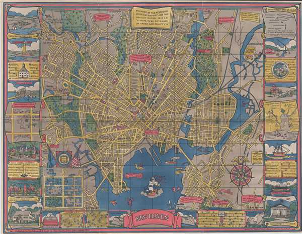

Title
New Haven.
1928 (dated) 27.5 x 35.5 in (69.85 x 90.17 cm) 1 : 24000
1928 (dated) 27.5 x 35.5 in (69.85 x 90.17 cm) 1 : 24000
Description
FOR THE ORIGINAL ANTIQUE MAP, WITH HISTORICAL ANALYSIS, CLICK HERE.
Digital Map Information
Geographicus maintains an archive of high-resolution rare map scans. We scan our maps at 300 DPI or higher, with newer images being 600 DPI, (either TIFF or JPEG, depending on when the scan was done) which is most cases in suitable for enlargement and printing.
Delivery
Once you purchase our digital scan service, you will receive a download link via email - usually within seconds. Digital orders are delivered as ZIP files, an industry standard file compression protocol that any computer should be able to unpack. Some of our files are very large, and can take some time to download. Most files are saved into your computer's 'Downloads' folder. All delivery is electronic. No physical product is shipped.
Credit and Scope of Use
You can use your digial image any way you want! Our digital images are unrestricted by copyright and can be used, modified, and published freely. The textual description that accompanies the original antique map is not included in the sale of digital images and remains protected by copyright. That said, we put significant care and effort into scanning and editing these maps, and we’d appreciate a credit when possible. Should you wish to credit us, please use the following credit line:
Courtesy of Geographicus Rare Antique Maps (http://www.geographicus.com).
How Large Can I Print?
In general, at 300 DPI, you should at least be able to double the size of the actual image, more so with our 600 DPI images. So, if the original was 10 x 12 inches, you can print at 20 x 24 inches, without quality loss. If your display requirements can accommodate some loss in image quality, you can make it even larger. That being said, no quality of scan will allow you to blow up at 10 x 12 inch map to wall size without significant quality loss. For more information, it is best consult a printer or reprographics specialist.
Refunds
If the high resolution image you ordered is unavailable, we will fully refund your purchase. Otherwise, digital images scans are a service, not a tangible product, and cannot be returned or refunded once the download link is used.
Cartographer
Carina Eaglesfield Mortimer Milligan (March 19, 1890 - September 12, 1978) was an American architect. Born in Indianapolis, Indiana to James Theophilius Eaglesfield and Caroline Buckley Campbell, Milligan attended Sweet Briar College and the Cambridge School of Domestic Architecture. She designed houses, which were advertised in local newspapers. After the outbreak of World War II, Milligan worked with Miss Anne Morgan in the Comite American de Secour Civil in France. She married Ernest Mortimer in 1923, who died in 1937, and John Raymond Milligan in 1941, who died in 1959. More by this mapmaker...
References
Rumsey 7916.000. New Haven Museum Whitney Library Call Number G3784.N4M676 1928. OCLC 668395148.