This copy is copyright protected.
Copyright © 2025 Geographicus Rare Antique Maps
Digital Image: 1917 British Admiralty Nautical Chart / Map of New Zealand
NewZealand-admiralty-1917_d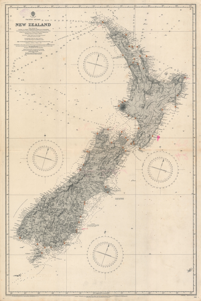

FOR THE ORIGINAL ANTIQUE MAP, WITH HISTORICAL ANALYSIS, CLICK HERE.
Digital Map Information
Geographicus maintains an archive of high-resolution rare map scans. We scan our maps at 300 DPI or higher, with newer images being 600 DPI, (either TIFF or JPEG, depending on when the scan was done) which is most cases in suitable for enlargement and printing.
Delivery
Once you purchase our digital scan service, you will receive a download link via email - usually within seconds. Digital orders are delivered as ZIP files, an industry standard file compression protocol that any computer should be able to unpack. Some of our files are very large, and can take some time to download. Most files are saved into your computer's 'Downloads' folder. All delivery is electronic. No physical product is shipped.
Credit and Scope of Use
You can use your digial image any way you want! Our digital images are unrestricted by copyright and can be used, modified, and published freely. The textual description that accompanies the original antique map is not included in the sale of digital images and remains protected by copyright. That said, we put significant care and effort into scanning and editing these maps, and we’d appreciate a credit when possible. Should you wish to credit us, please use the following credit line:
Courtesy of Geographicus Rare Antique Maps (http://www.geographicus.com).
How Large Can I Print?
In general, at 300 DPI, you should at least be able to double the size of the actual image, more so with our 600 DPI images. So, if the original was 10 x 12 inches, you can print at 20 x 24 inches, without quality loss. If your display requirements can accommodate some loss in image quality, you can make it even larger. That being said, no quality of scan will allow you to blow up at 10 x 12 inch map to wall size without significant quality loss. For more information, it is best consult a printer or reprographics specialist.
Refunds
If the high resolution image you ordered is unavailable, we will fully refund your purchase. Otherwise, digital images scans are a service, not a tangible product, and cannot be returned or refunded once the download link is used.
The British Admiralty Office (1795 - Present) or the United Kingdom Hydrographic Office refers to the Branch of the English government that is responsible for the command of the British Navy. In 1795 King George III created the United Kingdom Hydrographic Office, known in short as the U.K.H.O., to provide top notch nautical charts to the vast Royal Navy. Prior the founding of the Admiralty the surveying and creation of nautical charts was primarily a commercial venture wherein the cartographer himself, more of than not, actually financed the printing of his own material. The great navigator Cook himself is known to have scrambled for funds to publish his own seminal charts - the most important and advanced of the period. The system of privately funded nautical mapping and publishing left vast portions of the world uncharted and many excellent charts unpublished. King George III, responding significant loss in trade revenue related to shipwrecks and delay due to poor charts, recognized the need for an institutionalized government sponsored cartographic agency - the Admiralty. The first head of the Admiralty, a position known as Hydrographer, was the important cartographer Alexander Dalrymple. Dalrymple started by organizing and cataloging obtainable charts before initiating the laborious process of updating them and filling in the blanks. The first official Admiralty Chart appeared in 1800 and detailed Quiberon Bay in Brittany. By 1808 the position of Hydrographer fell to Captain Thomas Hurd. Hurd advocated the sale of Admiralty charts to the general public and, by the time he retired in 1829, had issued and published some 736 charts. Stewardship of the organization then passed to Rear Admiral Sir Francis Beaufort. It was under Beaufort's administration that the Admiralty truly developed as a "chart making" as opposed to a "chart cataloging" institution. Beaufort held his post from 1829 to 1854. In his 25 years at the Admiralty Beaufort created nearly 1500 new charts and sponsored countless surveying and scientific expeditions - including the 1831 to 1836 voyage of the H.M.S. Beagle. By 1855 the Admiralty's chart catalog listed some 1,981 charts. More by this mapmaker...
Davies and Company (fl. c. 1880 - 1930) was an engraving and lithography firm active in London during the late 19th century. The firm engraved nautical charts for the British Admiralty Hydrographic offices in the 1880s to the early 1920s. The firm may be the successor of Davies, Bryer, and Company (fl. 1866 - 1872), who also worked with the Admiralty, which dissolved in 1872. It may also be related to the firm of Robert Davies, Maddock, and Company, which was dissolved in 1905. Their imprint, as Davies and Company, appears as early as 1880 and as late as the 1920s, but the firm may have closed its doors by that point and the imprints persist on map plates only as a legacy. Learn More...
John Lort Stokes (August 1, 1811 – June 11, 1885) was a British Royal Navy officer, explorer, and hydrographer. Stokes grew up in Scotchwell near Haverfordwest, Pembrokeshire. He joined the Royal Navy on September 20, 1824. Stokes is famous as the commander of the HMS Beagle. He was assigned to the Beagle in 1824, acquiring the rank of midshipman in 1825, mate and surveyor in 1831, lieutenant in 1837, and commander in 1841. He remained with the HMS Beaglefor a total of 18 years, including during this historic 1833-1836 voyage of naturalist Charles Darwin, with whom he shared a cabin. Following the Darwin voyages in South America, the HMS Beagle was reassigned to Australia, where it carried out survey of the Australia coast. It was during this period that Stokes succeeded John Wickham as commander of the HMS Beagle. He was later given command of the HMS Acheron, with which he continued his survey of the Australian coastline. Stokes's delighted in exploration and his contribution to Australian cartography was significant, and includes the discovery of the Victory River, Port Darwin, the Flinders Rivers, and the Albert Rivers. He was speared by Aboriginals in 1839, but had full recovered by 1840. Stokes produced a several detailed charts of the Australian coast that, due to their accuracy, were still use nearly 100 years later. He retired from active duty in 1877, settling on his family estate in Scotchwell, Pembrokeshire, Wales. Learn More...
Copyright © 2025 Geographicus Rare Antique Maps | Geographicus Rare Antique Maps
This copy is copyright protected.
Copyright © 2025 Geographicus Rare Antique Maps