This copy is copyright protected.
Copyright © 2025 Geographicus Rare Antique Maps
Digital Image: 1702 Van Keulen Map of New York City, Long Island, Hudson River (New Amsterdam)
NiewNederlandNiewYork-vankeulen-1702_d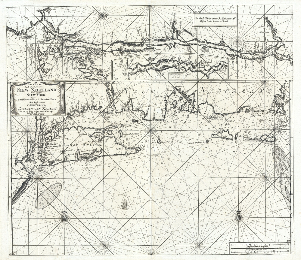

FOR THE ORIGINAL ANTIQUE MAP, WITH HISTORICAL ANALYSIS, CLICK HERE.
Digital Map Information
Geographicus maintains an archive of high-resolution rare map scans. We scan our maps at 300 DPI or higher, with newer images being 600 DPI, (either TIFF or JPEG, depending on when the scan was done) which is most cases in suitable for enlargement and printing.
Delivery
Once you purchase our digital scan service, you will receive a download link via email - usually within seconds. Digital orders are delivered as ZIP files, an industry standard file compression protocol that any computer should be able to unpack. Some of our files are very large, and can take some time to download. Most files are saved into your computer's 'Downloads' folder. All delivery is electronic. No physical product is shipped.
Credit and Scope of Use
You can use your digial image any way you want! Our digital images are unrestricted by copyright and can be used, modified, and published freely. The textual description that accompanies the original antique map is not included in the sale of digital images and remains protected by copyright. That said, we put significant care and effort into scanning and editing these maps, and we’d appreciate a credit when possible. Should you wish to credit us, please use the following credit line:
Courtesy of Geographicus Rare Antique Maps (http://www.geographicus.com).
How Large Can I Print?
In general, at 300 DPI, you should at least be able to double the size of the actual image, more so with our 600 DPI images. So, if the original was 10 x 12 inches, you can print at 20 x 24 inches, without quality loss. If your display requirements can accommodate some loss in image quality, you can make it even larger. That being said, no quality of scan will allow you to blow up at 10 x 12 inch map to wall size without significant quality loss. For more information, it is best consult a printer or reprographics specialist.
Refunds
If the high resolution image you ordered is unavailable, we will fully refund your purchase. Otherwise, digital images scans are a service, not a tangible product, and cannot be returned or refunded once the download link is used.
Johannes Van Keulen (1654 – 1715) was a Dutch cartographer active in Amsterdam during the late 17th century. Van Keulen was the son of Lucas van Keulen. Van Keulen's firm, ‘In de Gekroonde Lootsman' (In the Crowned Pilot), was founded in 1678 and registered with the Amsterdam bookseller's guild as 'Cross staff-maker and bookseller.' (The cross-staff is a nautical instrument used to determine latitude.) Two years later, in 1680, they obtained a patent from the States General of Holland and West Friesland to publish nautical charts and atlases. Together with his partner, the cartographer Claes Janz Vooght, Van Keulen published numerous atlases and nautical charts, including the Zee Atlas and Nieuwe Lichtende Zee-Fakkel. It was a massive five-volume atlas containing more than 130 nautical charts. The Zee-Fakkel established the Van Keulen firm as the pre-eminent maker of Dutch sea charts in the late 17th and early 18th century. In 1714, one year before Johannes Van Keulen's death, his son, Gerard van Keulen (1678 - 1726), took charge. Gerard continued to update and republish the Zee-Fakkel until his own death in 1726. The firm was later passed on to Gerard's son, Johannes II Van Keulen (1704 - 1755), who significantly updated the atlas, especially with regard to Asia, issuing the 1753 4th Volume, known as the 'Secret Atlas'. The final editions of the atlas were published by Gerard Hulst van Keulen (1733 - 1801), Joannes II's son. The final true Van Keulen edition of the Zee-Fakkel was published posthumously in 1803. It is noteworthy that though ostensibly controlled by the Van Keulen men, it was the Van Keulen widows who maintained and managed the firm in the periods following their husbands' deaths. After the death of Gerard Hulst Van Keulen's son, Johannes Hulst Van Keulen, ownership of the family plates and business fell into the hands of the Swart family, who continued to publish until the company closed its doors 1885, ending a cartographic legacy spanning nearly 207 years. More by this mapmaker...
Claes Jansz Vooght (1638 – 1696) was a Dutch astronomer, mathematician, teacher, surveyor and cartographer active in Amsterdam during the 17th century. Vooght described himself as a 'surveyor and teacher of mathematics and the art of navigation' and published extensively on these subjects. His is known to have been a surveyor for the Council of Holland and co-authored several books with Rembrantsz Dirck van Nierop. Though little is known of Vooght's life, his most important cartographic work appeared in conjunction with the prominent Johannes Van Keulen firm, with whom he partnered in 1680. Vooght was responsible for creating and compiling most of the maps in Van Keulen's seminal Nieuwe Lichtende Zee-Fakkel, with many early editions bearing only his name. Learn More...
Copyright © 2025 Geographicus Rare Antique Maps | Geographicus Rare Antique Maps
This copy is copyright protected.
Copyright © 2025 Geographicus Rare Antique Maps