This copy is copyright protected.
Copyright © 2025 Geographicus Rare Antique Maps
Digital Image: 1593 Cornelis De Jode Map of North America
NorthAmerica-dejode-1593_d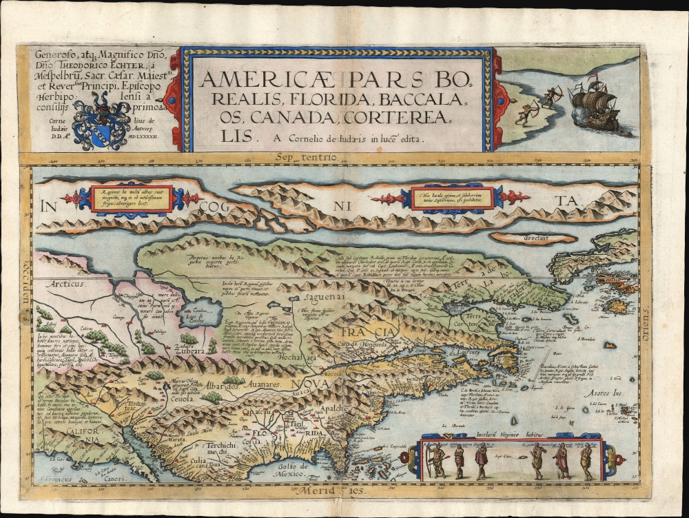


FOR THE ORIGINAL ANTIQUE MAP, WITH HISTORICAL ANALYSIS, CLICK HERE.
Digital Map Information
Geographicus maintains an archive of high-resolution rare map scans. We scan our maps at 300 DPI or higher, with newer images being 600 DPI, (either TIFF or JPEG, depending on when the scan was done) which is most cases in suitable for enlargement and printing.
Delivery
Once you purchase our digital scan service, you will receive a download link via email - usually within seconds. Digital orders are delivered as ZIP files, an industry standard file compression protocol that any computer should be able to unpack. Some of our files are very large, and can take some time to download. Most files are saved into your computer's 'Downloads' folder. All delivery is electronic. No physical product is shipped.
Credit and Scope of Use
You can use your digial image any way you want! Our digital images are unrestricted by copyright and can be used, modified, and published freely. The textual description that accompanies the original antique map is not included in the sale of digital images and remains protected by copyright. That said, we put significant care and effort into scanning and editing these maps, and we’d appreciate a credit when possible. Should you wish to credit us, please use the following credit line:
Courtesy of Geographicus Rare Antique Maps (http://www.geographicus.com).
How Large Can I Print?
In general, at 300 DPI, you should at least be able to double the size of the actual image, more so with our 600 DPI images. So, if the original was 10 x 12 inches, you can print at 20 x 24 inches, without quality loss. If your display requirements can accommodate some loss in image quality, you can make it even larger. That being said, no quality of scan will allow you to blow up at 10 x 12 inch map to wall size without significant quality loss. For more information, it is best consult a printer or reprographics specialist.
Refunds
If the high resolution image you ordered is unavailable, we will fully refund your purchase. Otherwise, digital images scans are a service, not a tangible product, and cannot be returned or refunded once the download link is used.
Cornelis de Jode (1568 – October 17, 1600) was an Antwerp cartographer, engraver and publisher, He was the son and heir of Gerard de Jode, also a cartographer and publisher. Cornelis studied science at Academy of Douai, but it can be understood that his main education in the trade was at the hands of his father. On his father's death in 1591, Cornelis de Jode took over the work on his father's atlas, Speculum Orbis Terrarum. This had enjoyed publication in a single edition of 1578, overshadowed by the competition posed by Abraham Ortelius' (1527 - 1598) Theatrum Orbis Terrrum. Cornelis published a second edition, to which he added many updated maps to bring the work up to date with its competition. Despite the improvements brought to the atlas, both aesthetic and geographic, De Jode was unable to break Ortelius' grip on the market and there were no further editions of the atlas. After his death, the engraving plates were sold to Ortelius' executor Johannes Baptista Vrients (1552 - 1612), who was continuing to publish the Theatrum. Vrients would utilize several decorative plates from the Speculum, but the complete work and its maps were not published again - likely they were destroyed by Vrients to keep them from competing with his editions of the i>Theatrum. More by this mapmaker...
Petrus Plancius (1522 - May 15, 1622) was a Dutch-Flemish cartographer, astronomer, and clergyman. Born in Dranouter, he studied theology in Germany and England. He became a minister in the Dutch Reformed Church at the age of 24. In 1585, fearing religious prosecution by the Inquisition after Brussels fell into Spanish hands, Plancius fled to Amsterdam. It was in Amsterdam that he became interested in navigation and cartography and soon became a recognized expert on the shipping routes to India. Plancius published his best known world map in 1592, entitled ‘Nova et exacta Terrarum Tabula geographic et hydrographica’. Plancius was also one of the founders of the Dutch East India Company, for which he drew over 100 maps. Learn More...
Copyright © 2025 Geographicus Rare Antique Maps | Geographicus Rare Antique Maps
This copy is copyright protected.
Copyright © 2025 Geographicus Rare Antique Maps