This copy is copyright protected.
Copyright © 2025 Geographicus Rare Antique Maps
Digital Image: 1891 General Survey Office Map of the North Island of New Zealand
NorthIsland-surveyoffice-1891_d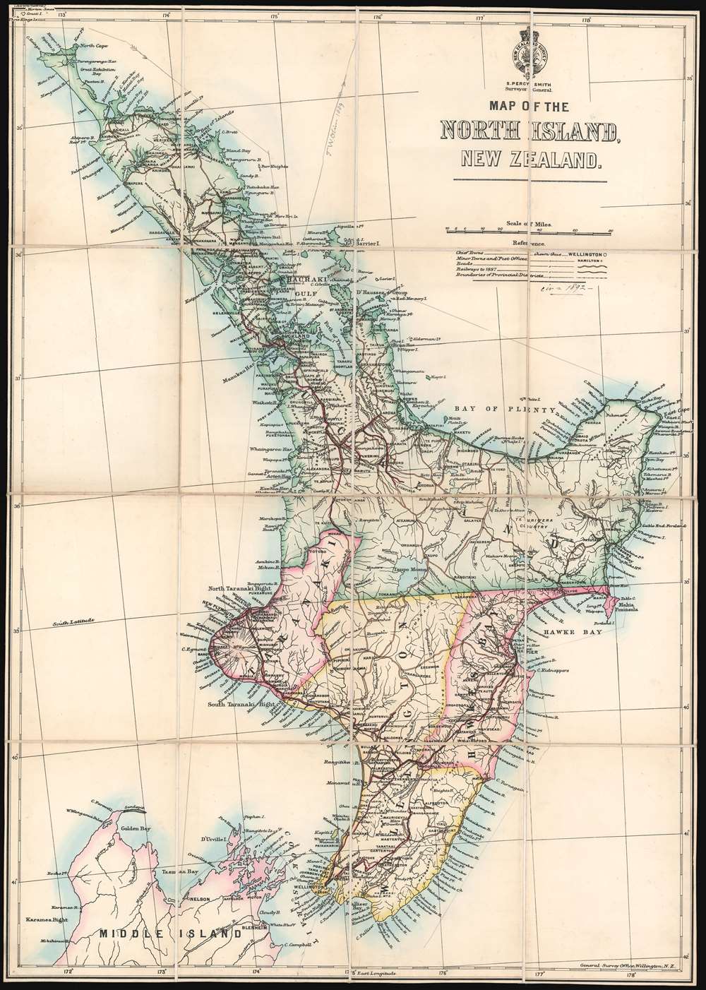

FOR THE ORIGINAL ANTIQUE MAP, WITH HISTORICAL ANALYSIS, CLICK HERE.
Digital Map Information
Geographicus maintains an archive of high-resolution rare map scans. We scan our maps at 300 DPI or higher, with newer images being 600 DPI, (either TIFF or JPEG, depending on when the scan was done) which is most cases in suitable for enlargement and printing.
Delivery
Once you purchase our digital scan service, you will receive a download link via email - usually within seconds. Digital orders are delivered as ZIP files, an industry standard file compression protocol that any computer should be able to unpack. Some of our files are very large, and can take some time to download. Most files are saved into your computer's 'Downloads' folder. All delivery is electronic. No physical product is shipped.
Credit and Scope of Use
You can use your digial image any way you want! Our digital images are unrestricted by copyright and can be used, modified, and published freely. The textual description that accompanies the original antique map is not included in the sale of digital images and remains protected by copyright. That said, we put significant care and effort into scanning and editing these maps, and we’d appreciate a credit when possible. Should you wish to credit us, please use the following credit line:
Courtesy of Geographicus Rare Antique Maps (http://www.geographicus.com).
How Large Can I Print?
In general, at 300 DPI, you should at least be able to double the size of the actual image, more so with our 600 DPI images. So, if the original was 10 x 12 inches, you can print at 20 x 24 inches, without quality loss. If your display requirements can accommodate some loss in image quality, you can make it even larger. That being said, no quality of scan will allow you to blow up at 10 x 12 inch map to wall size without significant quality loss. For more information, it is best consult a printer or reprographics specialist.
Refunds
If the high resolution image you ordered is unavailable, we will fully refund your purchase. Otherwise, digital images scans are a service, not a tangible product, and cannot be returned or refunded once the download link is used.
Stephenson Percy Smith (June 11, 1840 - April 19, 1922) was a British surveyor and ethnologist who spent nearly his entire life in New Zealand. Born in Beccles, Suffolk, England. Known as Percy all his life, Smith's parents, John Stephenson Smith and Hannah Hursthouse, moved the family to New Plymouth, New Zealand, in the fall of 1849. Smith attended school in New Plymouth and Omata before ending his studies in 1854 to help on the family farm. He joined the provincial survey department in February 1855, spending his spare time going out of surveying excursions. He and four others set out on a two-month expedition into the interior of the North Island in January 1858 covering over 600 miles on foot, by canoe, and on horseback. Smith moved to Auckland in 1862, where he married Mary Anne Crompton on April 23, 1863, and stayed there until he was given a position in New Plymouth as district surveyor. Smith spent the years from 1864 tunic 1874 working on numerous different surveying projects around New Zealand, and his hard work was rewarded with several promotions. Smith was named assistant surveyor general in 1881, and commissioner of Crown lands for the Auckland district in 1888. He became surveyor general and secretary for lands and mines in January 1889 and held these positions until his retirement on October 30, 1900. Smith was also a founding member of the Polynesian Society. Today, Smith's work is remembered for its groundbreaking achievements, but also recognized for its faults. Most of his research concerning the Maori is generally accepted as unreliable today, but it is important to remember that his studies laid the groundwork for ethnology in New Zealand. Smith died on April 19, 1922, eleven years after his wife. Percy and Mary had four children together. More by this mapmaker...
Copyright © 2025 Geographicus Rare Antique Maps | Geographicus Rare Antique Maps
This copy is copyright protected.
Copyright © 2025 Geographicus Rare Antique Maps