This copy is copyright protected.
Copyright © 2025 Geographicus Rare Antique Maps
Digital Image: 1936 William Mark Young Pictorial Map of Illinois, Ohio, Indiana, Michigan, and Wisco
OldNorthwestTerritory-williammarkyoung-1936_d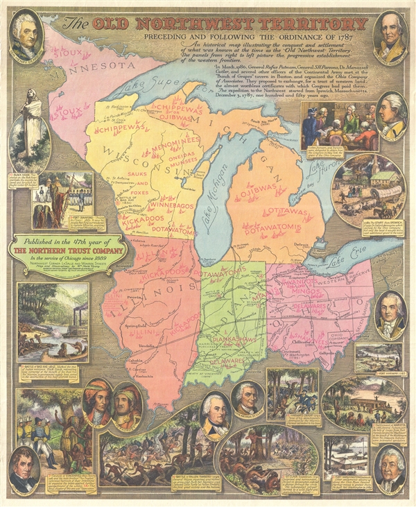

FOR THE ORIGINAL ANTIQUE MAP, WITH HISTORICAL ANALYSIS, CLICK HERE.
Digital Map Information
Geographicus maintains an archive of high-resolution rare map scans. We scan our maps at 300 DPI or higher, with newer images being 600 DPI, (either TIFF or JPEG, depending on when the scan was done) which is most cases in suitable for enlargement and printing.
Delivery
Once you purchase our digital scan service, you will receive a download link via email - usually within seconds. Digital orders are delivered as ZIP files, an industry standard file compression protocol that any computer should be able to unpack. Some of our files are very large, and can take some time to download. Most files are saved into your computer's 'Downloads' folder. All delivery is electronic. No physical product is shipped.
Credit and Scope of Use
You can use your digial image any way you want! Our digital images are unrestricted by copyright and can be used, modified, and published freely. The textual description that accompanies the original antique map is not included in the sale of digital images and remains protected by copyright. That said, we put significant care and effort into scanning and editing these maps, and we’d appreciate a credit when possible. Should you wish to credit us, please use the following credit line:
Courtesy of Geographicus Rare Antique Maps (http://www.geographicus.com).
How Large Can I Print?
In general, at 300 DPI, you should at least be able to double the size of the actual image, more so with our 600 DPI images. So, if the original was 10 x 12 inches, you can print at 20 x 24 inches, without quality loss. If your display requirements can accommodate some loss in image quality, you can make it even larger. That being said, no quality of scan will allow you to blow up at 10 x 12 inch map to wall size without significant quality loss. For more information, it is best consult a printer or reprographics specialist.
Refunds
If the high resolution image you ordered is unavailable, we will fully refund your purchase. Otherwise, digital images scans are a service, not a tangible product, and cannot be returned or refunded once the download link is used.
William Mark Young (March 18, 1881 – January 1, 1946) was an American etching artist, muralist, and commercial draughtsman active in Chicago during the first half of the 20th century. Young was born in Upper Alton, where he attended Upper Alton High School before moving on to Washington University's school of fine arts in St. Louis. His first business venture was a commercial arts firm in St. Louis. In time he moved to Chicago where his most substantial work was produced. Young is known for commercial art etching and painting, advertising, murals, and illustrations. His most impressive works were the murals issued for the Ohio Exhibit at the 1933 Chicago 'Century of Progress' World's Fair. These murals were subsequently relocated to the Ohio State Capital Building. In addition, young illustrated children's books, including a 1939 edition of Dickens' A Christmas Carol, and several books for Whitman Publishing Company in the Big Little Books and Better Little Books series. Young died on New Year's day, 1946. More by this mapmaker...
Ralph Henry Gabriel (1890 – 1987) was an American academic, historian, publisher, and editor. He taught history at Yale University for forty-three years (1915-1958) and served as chairman of the History Department (1931-1934). Gabriel also taught at the United States School of Military Government (1943-1946) and was active in the American Historical Association. He was the general editor of the Pageant of America series and the Library of Congress Series in American Civilization. Learn More...
Copyright © 2025 Geographicus Rare Antique Maps | Geographicus Rare Antique Maps
This copy is copyright protected.
Copyright © 2025 Geographicus Rare Antique Maps