This copy is copyright protected.
Copyright © 2025 Geographicus Rare Antique Maps
Digital Image: 1585 De Jode Broadside of Humanist Cosmography
OrdoUniversi-jodegerardde-1585_d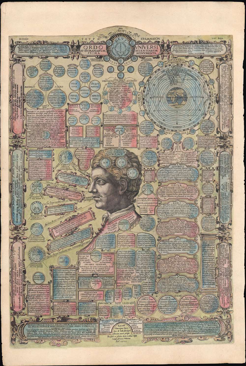

FOR THE ORIGINAL ANTIQUE MAP, WITH HISTORICAL ANALYSIS, CLICK HERE.
Digital Map Information
Geographicus maintains an archive of high-resolution rare map scans. We scan our maps at 300 DPI or higher, with newer images being 600 DPI, (either TIFF or JPEG, depending on when the scan was done) which is most cases in suitable for enlargement and printing.
Delivery
Once you purchase our digital scan service, you will receive a download link via email - usually within seconds. Digital orders are delivered as ZIP files, an industry standard file compression protocol that any computer should be able to unpack. Some of our files are very large, and can take some time to download. Most files are saved into your computer's 'Downloads' folder. All delivery is electronic. No physical product is shipped.
Credit and Scope of Use
You can use your digial image any way you want! Our digital images are unrestricted by copyright and can be used, modified, and published freely. The textual description that accompanies the original antique map is not included in the sale of digital images and remains protected by copyright. That said, we put significant care and effort into scanning and editing these maps, and we’d appreciate a credit when possible. Should you wish to credit us, please use the following credit line:
Courtesy of Geographicus Rare Antique Maps (http://www.geographicus.com).
How Large Can I Print?
In general, at 300 DPI, you should at least be able to double the size of the actual image, more so with our 600 DPI images. So, if the original was 10 x 12 inches, you can print at 20 x 24 inches, without quality loss. If your display requirements can accommodate some loss in image quality, you can make it even larger. That being said, no quality of scan will allow you to blow up at 10 x 12 inch map to wall size without significant quality loss. For more information, it is best consult a printer or reprographics specialist.
Refunds
If the high resolution image you ordered is unavailable, we will fully refund your purchase. Otherwise, digital images scans are a service, not a tangible product, and cannot be returned or refunded once the download link is used.
Gerard De Jode (1516/17 - February 5, 1591) was a Dutch publisher, engraver and cartographer active in Antwerp in the mid-to-late 16th century. De Jode was born in Nijmegen. Following a period as an apprentice and journeyman, (about which nothing comes down to us), he was admitted as a free master to Antwerp's artists' Guild of Saint Luke in 1547. He received the right to publish in that city in 1551. Henceforth he worked as a publisher and printseller in that city - although records also refer to him as a bookseller, art seller, map painter, engraver, and plate printer. He became one of Antwerp's most successful and prolific printers: he built up a large and varied stock of more than 1,200 prints and maps, and in addition to his own children maintained a shop and was taking on apprentices as early as 1549. De Jode's shop was home to many of Antwerp's best engravers, including the famous Van Doetecum brothers.
His publication in 1579 of the Thesaurus sacrarumhistoriarum veteris testamenti set the standard for over a century of Biblical illustration. His cartographic work began with the printing of other mapmakers' work (for example Gastaldi's map of the world in 1555, Jacob van Deventer's map of Brabant in 1558, and Ortelius' eight sheet map of the world in 1564.) He is best known for his 1578 atlas Speculum Orbis Terrarum. Despite the excellence of this work, it performed poorly due to the overwhelming competition posed by Abraham Ortelius' Theatrum Orbis Terrarum, which had already been eight years in publication. Between the Theatrum's popularity (and Ortelius' superior political connections, employed successfully in a vigorous defense of his license and monopoly on the work) De Jode's atlas was never a strong seller. Gerard printed only one edition of the work, compared to something on the order of 40 for the Ortelius atlas. Gerard de Jode planned an enlarged edition, but died before it could be finished. His son Cornelis de Jode completed the labor, publishing the Speculum Orbis Terrae in 1593. This edition, too, of the Speculum failed to compete with Ortelius' powerhouse. On top of that, much of the De Jodes' stock was actively purchased and destroyed by Ortelius and his executors in order to remove it from the market. Thus, oneresult of De Jode's ill-starred competition with Ortelius is that while most of Ortelius' maps are relatively ubiquitous on the market, all of De Jode's maps are rare, and sought after by the discerning collector.
More by this mapmaker...
Andrea Bacci (1524 - October 24, 1600) was an Italian physician, naturalist, philosopher, and humanist. He was born Born at Sant'Elpidio a Mare, and entered the medical profession at Serra San Quirico, around 1551. He wrote works on hydrology, pharmacology, zoology, mineralogy and (extensively) on enology. He served in Rome as chief physician to the Pope. Learn More...
Adriaen Huberti (fl. 1573 - c. 1614) was a Flemish engraver and printer. He became a master and member of the Antwerp Guild in 1573. He is known to have engraved at least one broadsheet for Gerard De Jode, and also produced engravings under his own aegis for sale to the Spanish market. Learn More...
Copyright © 2025 Geographicus Rare Antique Maps | Geographicus Rare Antique Maps
This copy is copyright protected.
Copyright © 2025 Geographicus Rare Antique Maps