This copy is copyright protected.
Copyright © 2025 Geographicus Rare Antique Maps
Digital Image: 1946 Tomson City Planning Map for Palm Desert, California
PalmDesert-tomson-1946_d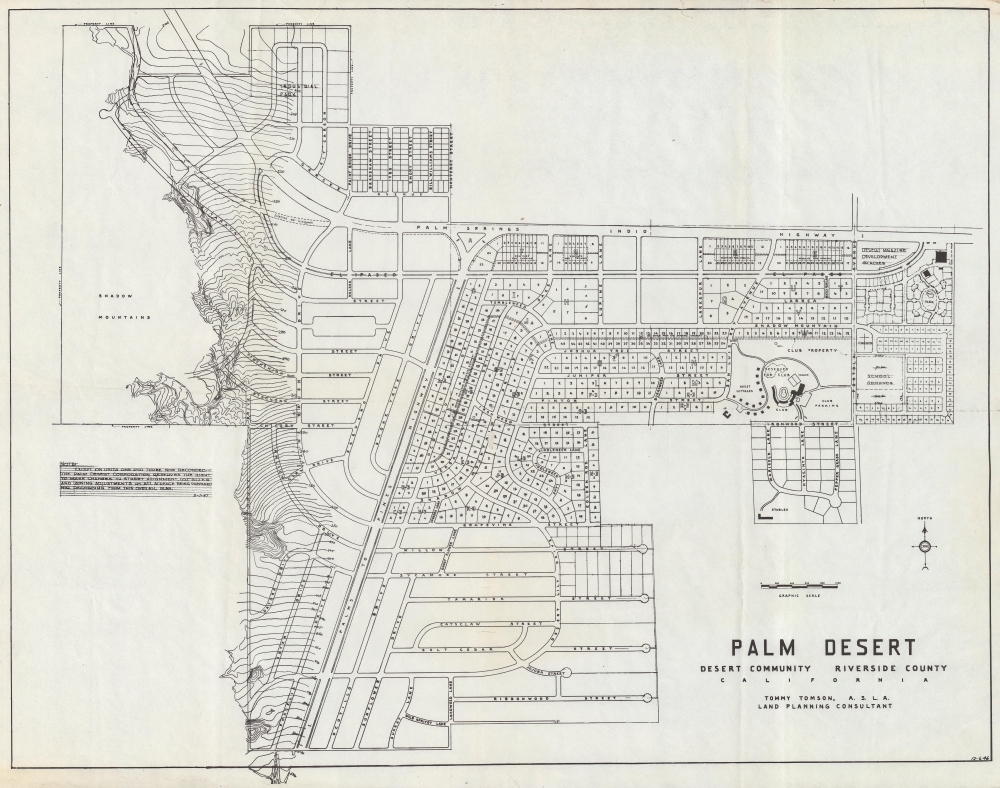

FOR THE ORIGINAL ANTIQUE MAP, WITH HISTORICAL ANALYSIS, CLICK HERE.
Digital Map Information
Geographicus maintains an archive of high-resolution rare map scans. We scan our maps at 300 DPI or higher, with newer images being 600 DPI, (either TIFF or JPEG, depending on when the scan was done) which is most cases in suitable for enlargement and printing.
Delivery
Once you purchase our digital scan service, you will receive a download link via email - usually within seconds. Digital orders are delivered as ZIP files, an industry standard file compression protocol that any computer should be able to unpack. Some of our files are very large, and can take some time to download. Most files are saved into your computer's 'Downloads' folder. All delivery is electronic. No physical product is shipped.
Credit and Scope of Use
You can use your digial image any way you want! Our digital images are unrestricted by copyright and can be used, modified, and published freely. The textual description that accompanies the original antique map is not included in the sale of digital images and remains protected by copyright. That said, we put significant care and effort into scanning and editing these maps, and we’d appreciate a credit when possible. Should you wish to credit us, please use the following credit line:
Courtesy of Geographicus Rare Antique Maps (http://www.geographicus.com).
How Large Can I Print?
In general, at 300 DPI, you should at least be able to double the size of the actual image, more so with our 600 DPI images. So, if the original was 10 x 12 inches, you can print at 20 x 24 inches, without quality loss. If your display requirements can accommodate some loss in image quality, you can make it even larger. That being said, no quality of scan will allow you to blow up at 10 x 12 inch map to wall size without significant quality loss. For more information, it is best consult a printer or reprographics specialist.
Refunds
If the high resolution image you ordered is unavailable, we will fully refund your purchase. Otherwise, digital images scans are a service, not a tangible product, and cannot be returned or refunded once the download link is used.
Tommy Tomson (1900 - 1986), also known as Charles G. Tomson and Golden Sands Tomson, was a surveyor, landscape architect, and urban planner closely associated with the development and history of Palm Desert, in California's Coachella Valley. Born in Zanesville, Ohio, Tomson trained as a surveyor in Michigan before relocating to the American Southwest, working in Albuquerque, Texas, and Hollywood. After briefly considering a career as an actor, Tomson committed to surveying and urban planning. In Los Angeles, he met and married Dorris Henderson, a California native from the inland desert to the east and south of Los Angeles. After a stint in Portland, Oregon, Tomson returned to Los Angeles, where he was tasked with planning the landscaping for the infield at the Santa Anita Park horse racing track. This project gained him acclaim and many new clients, including celebrities (the likes of Henry Fonda, Frank Sinatra, and Red Skelton) looking for elaborate landscaping for their homes. He was also given additional projects for public institutions, including a patio at Union Station, laying out swimming pools for hotels in Beverley Hills, and designing the landscaping for the Park La Brea housing community. His designs are credited with helping create the postwar image of Southern California defined by swimming pools, palm trees, and an adaptation of California's romanticized, mythologized past to homes designed with outdoor leisure in mind. He became particularly well known for his 'kidney shaped' and figure 8 swimming pool designs, as well as the famous piano-shaped swimming pool in Frank Sinatra's Palm Springs home. After the Second World War, Tomson and his four brothers-in-law undertook a project to develop land in the inland deserts of Southern California. Government-owned land, which had been used by the military during the war, was being sold at a very favorable price on the condition that investments and improvements were made to the land. The land chosen by Tomson and the Hendersons in 1946 was just off Highway 74, not far from Palm Springs, and was dubbed by one of Tomson's brothers-in-law as Palm Desert. Tomson chose a plot and built a house for his family, though they initially only stayed for weekends given the lack of services and infrastructure. Later, Tomson retired to a grand, distinctive Spanish-style 'hacienda' that he designed and built in Palm Desert, complete with a chapel, blacksmith shop, and faux ruins of an aqueduct. More by this mapmaker...
Copyright © 2025 Geographicus Rare Antique Maps | Geographicus Rare Antique Maps
This copy is copyright protected.
Copyright © 2025 Geographicus Rare Antique Maps