This copy is copyright protected.
Copyright © 2025 Geographicus Rare Antique Maps
Digital Image: 1739 Bretez - Turgot View and Map of Paris, France (c. 1900 Taride issue)
Paris4-turgot-1900_d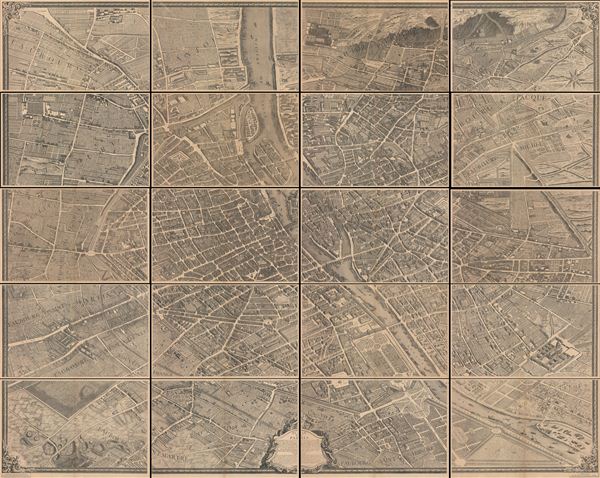

FOR THE ORIGINAL ANTIQUE MAP, WITH HISTORICAL ANALYSIS, CLICK HERE.
Digital Map Information
Geographicus maintains an archive of high-resolution rare map scans. We scan our maps at 300 DPI or higher, with newer images being 600 DPI, (either TIFF or JPEG, depending on when the scan was done) which is most cases in suitable for enlargement and printing.
Delivery
Once you purchase our digital scan service, you will receive a download link via email - usually within seconds. Digital orders are delivered as ZIP files, an industry standard file compression protocol that any computer should be able to unpack. Some of our files are very large, and can take some time to download. Most files are saved into your computer's 'Downloads' folder. All delivery is electronic. No physical product is shipped.
Credit and Scope of Use
You can use your digial image any way you want! Our digital images are unrestricted by copyright and can be used, modified, and published freely. The textual description that accompanies the original antique map is not included in the sale of digital images and remains protected by copyright. That said, we put significant care and effort into scanning and editing these maps, and we’d appreciate a credit when possible. Should you wish to credit us, please use the following credit line:
Courtesy of Geographicus Rare Antique Maps (http://www.geographicus.com).
How Large Can I Print?
In general, at 300 DPI, you should at least be able to double the size of the actual image, more so with our 600 DPI images. So, if the original was 10 x 12 inches, you can print at 20 x 24 inches, without quality loss. If your display requirements can accommodate some loss in image quality, you can make it even larger. That being said, no quality of scan will allow you to blow up at 10 x 12 inch map to wall size without significant quality loss. For more information, it is best consult a printer or reprographics specialist.
Refunds
If the high resolution image you ordered is unavailable, we will fully refund your purchase. Otherwise, digital images scans are a service, not a tangible product, and cannot be returned or refunded once the download link is used.
Louis Bretez (fl. 1700 - 1740) was French born sculptor and painter active in the early 18th century. Bretez was a member of the Academie Royale de Peinture et Sculpture in Paris where he specialized in perspective with regard to architecture. Bretez's greatest achievement was his production, with Claude Lucas, of the monumental Turgot Plan of Paris. This spectacular map, one of history's greatest achievements of urban cartography, occupied Bretez from 1734 to 1739. It depicts Paris from a bird's eye perspective with extraordinary detail to the level of individual buildings and trees. More by this mapmaker...
Michel-Étienne Turgot (1690-1751) a French businessman and civil administrator in the first half of the 18th century. From 1729 to 1740 he held the mayor-like office of Prévôt des Marchands de Paris ("Master of the merchants of Paris") under King Louis XV. Turgot's greatest claim to fame is his commissioning of Louis Bretez to assemble the spectacular Turgot Plan of Paris, one of the greatest feats of urban cartography ever undertaken. Turgot's more famous son, Anne-Robert-Jacques Turgot, attained prominence as a statesman and economist under Louis the XVI. Learn More...
Alphonse Taride (fl. c. 1850 - 1918) was a prolific Paris based publisher active in the late 19th and early 20th century. Publishing as "A. Taride", the firm produced a large corpus of work including numerous maps, tourist guides, histories, and pocket plans of different parts of France. With the advent of the automobile and improved roadways in the early 20th century, the name "Taride" became synonymous with high quality roadmaps. Taride had his offices at 18 - 20 Boulevard St. Denis, Paris. Learn More...
Copyright © 2025 Geographicus Rare Antique Maps | Geographicus Rare Antique Maps
This copy is copyright protected.
Copyright © 2025 Geographicus Rare Antique Maps