This copy is copyright protected.
Copyright © 2025 Geographicus Rare Antique Maps
Digital Image: 1928 Harold H. Brown Pictorial Map of the Holy Land / Israel / Palestine w/ Sinai
PictureMapHolyLand-brown-1928_d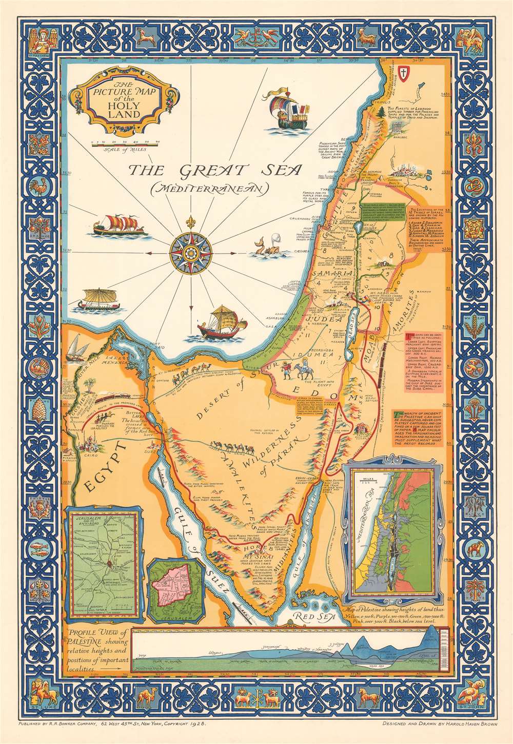

FOR THE ORIGINAL ANTIQUE MAP, WITH HISTORICAL ANALYSIS, CLICK HERE.
Digital Map Information
Geographicus maintains an archive of high-resolution rare map scans. We scan our maps at 300 DPI or higher, with newer images being 600 DPI, (either TIFF or JPEG, depending on when the scan was done) which is most cases in suitable for enlargement and printing.
Delivery
Once you purchase our digital scan service, you will receive a download link via email - usually within seconds. Digital orders are delivered as ZIP files, an industry standard file compression protocol that any computer should be able to unpack. Some of our files are very large, and can take some time to download. Most files are saved into your computer's 'Downloads' folder. All delivery is electronic. No physical product is shipped.
Credit and Scope of Use
You can use your digial image any way you want! Our digital images are unrestricted by copyright and can be used, modified, and published freely. The textual description that accompanies the original antique map is not included in the sale of digital images and remains protected by copyright. That said, we put significant care and effort into scanning and editing these maps, and we’d appreciate a credit when possible. Should you wish to credit us, please use the following credit line:
Courtesy of Geographicus Rare Antique Maps (http://www.geographicus.com).
How Large Can I Print?
In general, at 300 DPI, you should at least be able to double the size of the actual image, more so with our 600 DPI images. So, if the original was 10 x 12 inches, you can print at 20 x 24 inches, without quality loss. If your display requirements can accommodate some loss in image quality, you can make it even larger. That being said, no quality of scan will allow you to blow up at 10 x 12 inch map to wall size without significant quality loss. For more information, it is best consult a printer or reprographics specialist.
Refunds
If the high resolution image you ordered is unavailable, we will fully refund your purchase. Otherwise, digital images scans are a service, not a tangible product, and cannot be returned or refunded once the download link is used.
Harold Haven Brown (June 6, 1869 - April 7, 1932) was an American artist, cartographer, illustrator, teacher, painter, and museum director. Born in Malden, Massachusetts, Brown attended the Massachusetts Normal Art School before heading to Paris, France to study with Jean Leon Gérôme at the École des Beaux-Arts and with J.P. Laurens at the Académie Julian. Brown also spent significant amounts of time studying museum work at the Louvre, the Musée de Cluny, and the Musée du Luxembourg. He married Florence Bradshaw, a fellow artist, on November 4, 1897. The couple lived in Chicago and then Indianapolis, where Brown served as the director of the John Heron Institute, holding the position from 1913 until 1921. They then moved to Provincetown, Massachusetts in 1923. Brown was a noted mapmaker, and also created woodcuts and watercolors. He also wrote books and articles on calligraphy and on decorative, pictorial, and mechanical drawing. He and Florence played an important role in the founding of the Provincetown Art Association and Museum and Brown served as its president from 1926 until his death in 1932. He and Florence had two children. More by this mapmaker...
The R.R. Bowker Company (1868 - present) is an American company currently based in New Providence, New Jersey that provides bibliographic information on published works to the books trade, including publishers, libraries, booksellers, and individuals. Bowker is also the exclusive U.S. agent for issuing International Standard Book Numbers (ISBNs). The company was founded in 1868 in New York City by Frederick Leypoldt, a bookseller, to provide and compile bibliographic information with the goal of making the book business more efficient. He established the Literary Bulletin, his first periodical, that year and in 1870 issued the first edition of his Annual American Catalogue, the forerunner of Books in Print. The first issue of Publisher's Weekly was published in 1872, with the first issue of Publishers' Uniform Trade-List Annual appearing in 1873, and followed by the first issue of Library Journal in 1876. The company was acquired by Richard Rogers Bowker in 1878. The pair then founded two influential book-industry references: Literary Marketplace and Ulrich's Periodicals Directory. The R.R. Bowker company was acquired by the Xerox Corporation in 1967, which then sold it to Reed International in 1985. Also in 1985, Publisher's Weekly was transferred to the Cahners Publishing Company after 113 years as part of the R.R. Bowker Company. The Cambridge Information Group bought Bowker in 2001, and sold Literary Marketplace in 2007. After the Cambridge Information Group acquired ProQuest Information and Learning, R.R. Bowker was position as an affiliate of ProQuest. Learn More...
Copyright © 2025 Geographicus Rare Antique Maps | Geographicus Rare Antique Maps
This copy is copyright protected.
Copyright © 2025 Geographicus Rare Antique Maps