Digital Image: 1922 Unrecorded Survey Map of Pinellas County, Florida
PinellasCounty-burleson-1922_d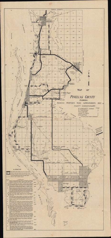

Title
Map of Pinellas County Florida Showing Road Improvements 1922.
1922 (dated) 22.5 x 10 in (57.15 x 25.4 cm) 1 : 110000
1922 (dated) 22.5 x 10 in (57.15 x 25.4 cm) 1 : 110000
Description
FOR THE ORIGINAL ANTIQUE MAP, WITH HISTORICAL ANALYSIS, CLICK HERE.
Digital Map Information
Geographicus maintains an archive of high-resolution rare map scans. We scan our maps at 300 DPI or higher, with newer images being 600 DPI, (either TIFF or JPEG, depending on when the scan was done) which is most cases in suitable for enlargement and printing.
Delivery
Once you purchase our digital scan service, you will receive a download link via email - usually within seconds. Digital orders are delivered as ZIP files, an industry standard file compression protocol that any computer should be able to unpack. Some of our files are very large, and can take some time to download. Most files are saved into your computer's 'Downloads' folder. All delivery is electronic. No physical product is shipped.
Credit and Scope of Use
You can use your digial image any way you want! Our digital images are unrestricted by copyright and can be used, modified, and published freely. The textual description that accompanies the original antique map is not included in the sale of digital images and remains protected by copyright. That said, we put significant care and effort into scanning and editing these maps, and we’d appreciate a credit when possible. Should you wish to credit us, please use the following credit line:
Courtesy of Geographicus Rare Antique Maps (http://www.geographicus.com).
How Large Can I Print?
In general, at 300 DPI, you should at least be able to double the size of the actual image, more so with our 600 DPI images. So, if the original was 10 x 12 inches, you can print at 20 x 24 inches, without quality loss. If your display requirements can accommodate some loss in image quality, you can make it even larger. That being said, no quality of scan will allow you to blow up at 10 x 12 inch map to wall size without significant quality loss. For more information, it is best consult a printer or reprographics specialist.
Refunds
If the high resolution image you ordered is unavailable, we will fully refund your purchase. Otherwise, digital images scans are a service, not a tangible product, and cannot be returned or refunded once the download link is used.
Cartographer
Carl E. Burleson (c. 1889 - 1961) was a civil engineer who served as the county engineer of Pinellas County, Florida during the 1920s Florida Land Boom. He is credited with designing many of the bridges constructed in the county during that decade. Burleson was born in North Carolina in 1889, raised in Tennessee, and first came to Florida in the early 20th century, settling in Pensacola. In the late 1910s, he moved to St. Petersburg and served as the county engineer for 22 years. Then, in the early-mid 1930s, he relocated to Jacksonville, before moving again to Volusia County in the mid-1940s, working for the State Road Department throughout as a maintenance engineer. His son Gordon followed in his footsteps and served as the director of engineering for the City of Orlando. Carl Burleson was one of the first registered engineers in Florida and a leader in the Florida Engineering Society and the American Society of Civil Engineers. More by this mapmaker...