This copy is copyright protected.
Copyright © 2025 Geographicus Rare Antique Maps
Digital Image: 1867 Depot de la Marine Nautical Chart or Map of Saint Martin Bay, Ile de Re, France
PlanSaintMartin-marine-1867_d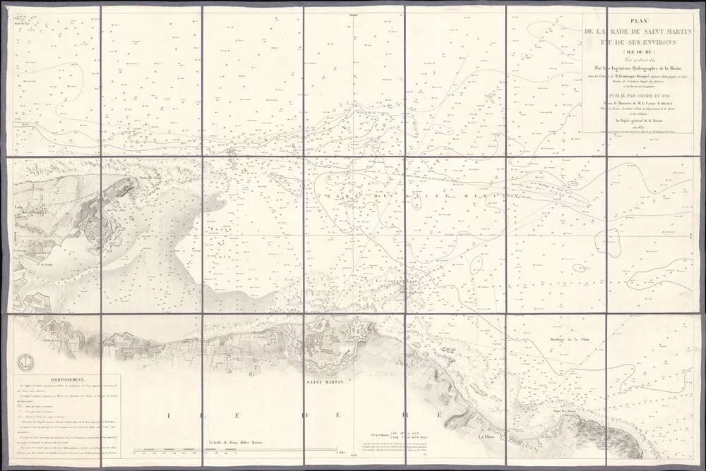

FOR THE ORIGINAL ANTIQUE MAP, WITH HISTORICAL ANALYSIS, CLICK HERE.
Digital Map Information
Geographicus maintains an archive of high-resolution rare map scans. We scan our maps at 300 DPI or higher, with newer images being 600 DPI, (either TIFF or JPEG, depending on when the scan was done) which is most cases in suitable for enlargement and printing.
Delivery
Once you purchase our digital scan service, you will receive a download link via email - usually within seconds. Digital orders are delivered as ZIP files, an industry standard file compression protocol that any computer should be able to unpack. Some of our files are very large, and can take some time to download. Most files are saved into your computer's 'Downloads' folder. All delivery is electronic. No physical product is shipped.
Credit and Scope of Use
You can use your digial image any way you want! Our digital images are unrestricted by copyright and can be used, modified, and published freely. The textual description that accompanies the original antique map is not included in the sale of digital images and remains protected by copyright. That said, we put significant care and effort into scanning and editing these maps, and we’d appreciate a credit when possible. Should you wish to credit us, please use the following credit line:
Courtesy of Geographicus Rare Antique Maps (http://www.geographicus.com).
How Large Can I Print?
In general, at 300 DPI, you should at least be able to double the size of the actual image, more so with our 600 DPI images. So, if the original was 10 x 12 inches, you can print at 20 x 24 inches, without quality loss. If your display requirements can accommodate some loss in image quality, you can make it even larger. That being said, no quality of scan will allow you to blow up at 10 x 12 inch map to wall size without significant quality loss. For more information, it is best consult a printer or reprographics specialist.
Refunds
If the high resolution image you ordered is unavailable, we will fully refund your purchase. Otherwise, digital images scans are a service, not a tangible product, and cannot be returned or refunded once the download link is used.
Dépôt des Cartes et Plans de la Marine (fl. 1720 - present), often called the Dépôt de Marine, was a French hydrographic mapping organization founded in 1720 under Charles-Hercule of Albert de Luynes (1674 - 1734). Much like the U.S. Coast Survey, the British Admiralty, and the Spanish Deposito Hydrografico, the Dépôt was initiated as a storehouse and distribution center of existing nautical and marine charts. Eventually the Dépôt initiated its own mapping activities in an attempt to improve and expand upon existing material. Some of the more prominent cartographers and hydrographers associated with the of Dépôt des Cartes were, Philippe Buache, Jacques-Nicholas Bellin, Giovanni Rizzi-Zannoni, Rigobert Bonne, and Jean Nicolas Buache. More by this mapmaker...
Anatole Bouquet de La Grye (May 29, 1827 - December 21, 1909) was a French hydrographic engineer. He graduated from the École Polytechnique in 1847. Bouquet de la Grye created maps of the island of Elbe, Tuscany, New Caledonia, and Alexandria over the course of his career. His most notable accomplishment was proposing and championing the creation of a La Pallice (also known as the grand port maritime de La Rochelle), a large deep-water commercial port at La Rochelle, France. He was elected as a member of the Academy of Sciences in 1884 and became President of the Academy in 1902. Learn More...
Charles-François Beautemps-Beaupré (August 6, 1766 - March 16, 1854) was a French hydrographic engineer and cartographer and was also a member of the Academy of Sciences. He is considered the father of modern hydrography. Beautemps-Beaupré began his career as a hydrographer in 1783 as a student of his uncle Jean-Nicolas Buache, who was the director of the dépôt de la Marine at the time. He became an engineer in 1785 and created his first maps that year. He was a member of the crew of La Recherche, which left France in 1791 under the command of Antoine Reymond Joseph de Bruni d'Entrecasteaux in search of the French explorer La Pérouse, who had disappeared in 1788. The expedition with La Recherche lasted until 1796, and Beautemps-Beaupré took advantage of these years to develop new foundations for hydrography, developing it into a true science and adopting methods that would soon be adopted by all mariners. When L'Appendice au voyage de D'Entrecasteaux was published in 1808, it contained all Beautemps-Beaupré's work from the voyage and it 'revolutionized hydrographic methods'. Beautemps-Beaupré was made sub curator of the dépôt des cartes et plans de la marine in 1799 and was put in charge of all major hydrographic work during the Empire and the Bourbon Restoration, making him among the few government officials to serve during both periods. He was elected to the Academy of Sciences in 1810. He was mad director of the dépôt des cartes et plans de la marine in 1814 and held the position until 1838. Over the course of his career, Beautemps-Beaupré created at least 613 distinct works, including over 150 maps and plans and 279 views. Learn More...
Copyright © 2025 Geographicus Rare Antique Maps | Geographicus Rare Antique Maps
This copy is copyright protected.
Copyright © 2025 Geographicus Rare Antique Maps