This copy is copyright protected.
Copyright © 2025 Geographicus Rare Antique Maps
Digital Image: 1860 Bourdin / Babinet Wall Map of the World on Mollweide Projection
PlanisphereBabinet-bourdin-1860_d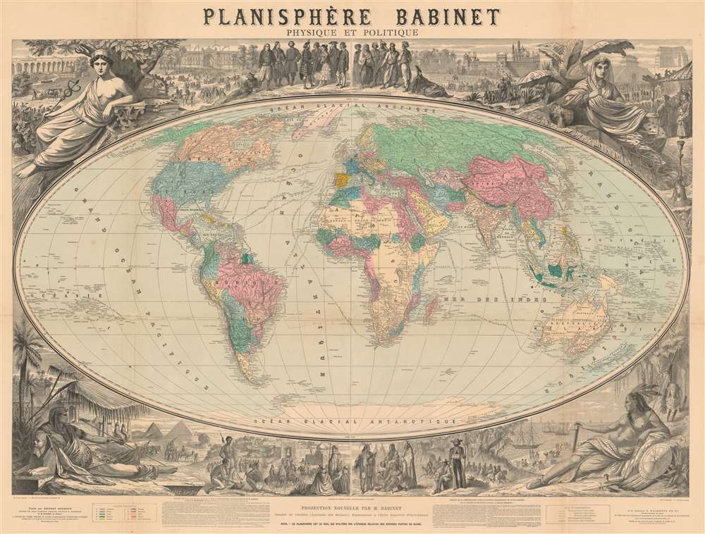

FOR THE ORIGINAL ANTIQUE MAP, WITH HISTORICAL ANALYSIS, CLICK HERE.
Digital Map Information
Geographicus maintains an archive of high-resolution rare map scans. We scan our maps at 300 DPI or higher, with newer images being 600 DPI, (either TIFF or JPEG, depending on when the scan was done) which is most cases in suitable for enlargement and printing.
Delivery
Once you purchase our digital scan service, you will receive a download link via email - usually within seconds. Digital orders are delivered as ZIP files, an industry standard file compression protocol that any computer should be able to unpack. Some of our files are very large, and can take some time to download. Most files are saved into your computer's 'Downloads' folder. All delivery is electronic. No physical product is shipped.
Credit and Scope of Use
You can use your digial image any way you want! Our digital images are unrestricted by copyright and can be used, modified, and published freely. The textual description that accompanies the original antique map is not included in the sale of digital images and remains protected by copyright. That said, we put significant care and effort into scanning and editing these maps, and we’d appreciate a credit when possible. Should you wish to credit us, please use the following credit line:
Courtesy of Geographicus Rare Antique Maps (http://www.geographicus.com).
How Large Can I Print?
In general, at 300 DPI, you should at least be able to double the size of the actual image, more so with our 600 DPI images. So, if the original was 10 x 12 inches, you can print at 20 x 24 inches, without quality loss. If your display requirements can accommodate some loss in image quality, you can make it even larger. That being said, no quality of scan will allow you to blow up at 10 x 12 inch map to wall size without significant quality loss. For more information, it is best consult a printer or reprographics specialist.
Refunds
If the high resolution image you ordered is unavailable, we will fully refund your purchase. Otherwise, digital images scans are a service, not a tangible product, and cannot be returned or refunded once the download link is used.
Ernest Bourdin (18?? - 18??) was a French publisher and printer active in the middle to late 19th century. His offices were located at 51 Rue e la Seine, Paris. Bourdin was a great supporter of the Mollweide / Babinet Projection and published an atlas using the system. His earliest publications date to the 1830s, with his latest work being in the late 1860s. More by this mapmaker...
Georges Erhard Schièble (1823 – November 23, 1880) was a German printer active in Paris during the middle to late 19th century. Erhard was born in Forchheim, Baden-Württemberg, and relocated to Paris in his 16th year, where he apprenticed under his cousin, an engraver and mapmaker. In 1852, after 6 years with the Royal Printing Office, he started his own business. Around this time, he also became a naturalized French citizen. From his offices on Rue Bonaparte, he produced several important maps, and a detailed topography of Gaul for Napoleon III's History of Julius Caesar. In 1865 he took on larger offices expanding his operations to include a lithographic press. He was among the first to introduce printed color maps and pioneered photo-reduction, including the process known as Erhard reproduction. After Erhard's death in 1880, the firm was taken over by his sons and run under the imprint of 'Erhard Frères' until 1911. Learn More...
Léon Louis Painlevé (May 22, 1832 - March 8, 1906) was a French engraver and architect active in Paris in the second half of the 19th century. He was born and died in Paris and is described as a lithographer of limited means. He is the father of Paul Prudent Painlevé (1863 - 1933), a noted scientist who became Prime Minister of France. Learn More...
Hachette and Company (fl. 1826 – present) was founded by Louis Hachette (1801 - 1864) in 1826 with the purchase of the Paris Bookshop Brédif. Shortly after acquiring the bookshop Louis Hachette began publishing Le Journal pour Tous, a successful general interest magazine. He also published a series of useful reference works which were sold through Paris in bookshops, train stations, and public offices. These included multiple maps and atlases geared toward the tourist visiting Paris for the first time. Louis Hachette himself died in 1864, but his empire continued to grow under the governance of his sons. Eventually the Hachette publishing firm came to dominate French publishing and attracted international interest. Via a series of mergers and acquisitions the firm eventually came under the control of Filipacchi Media and was rename Hachette-Filipacchi. Today the firm publishes books and magazines internationally. Learn More...
Copyright © 2025 Geographicus Rare Antique Maps | Geographicus Rare Antique Maps
This copy is copyright protected.
Copyright © 2025 Geographicus Rare Antique Maps