Digital Image: 1836 Featherstonhough Map of the American Midwest
PortionIndianTerritory-featherstonhough-1836_d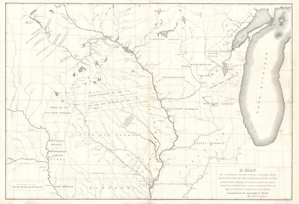

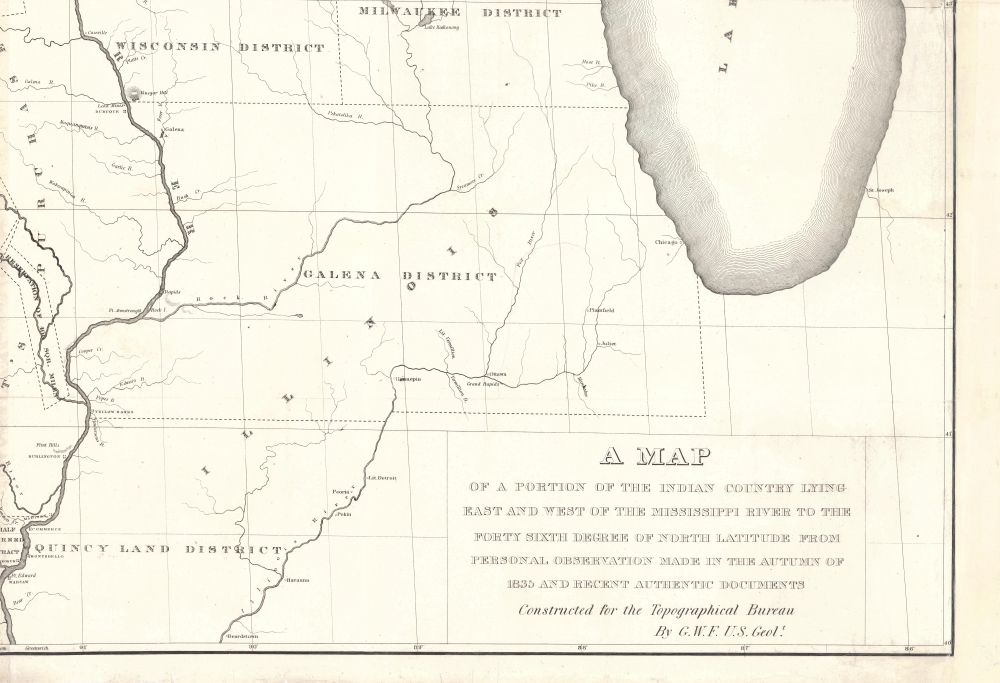


Title
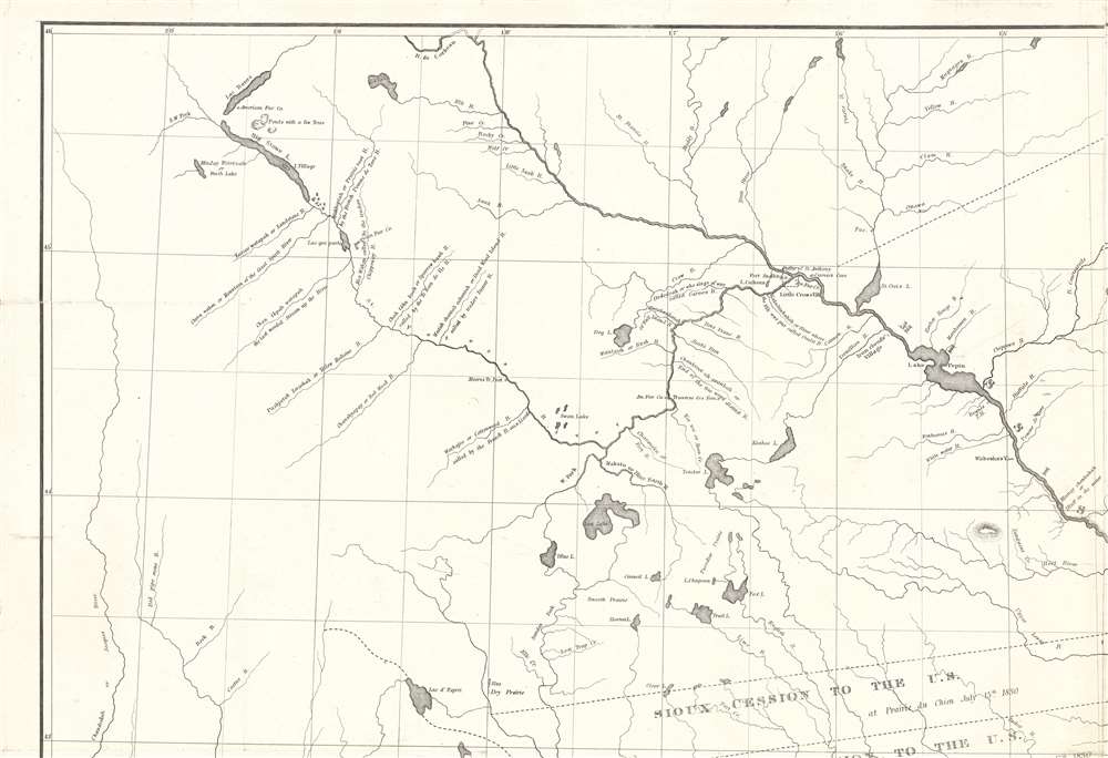
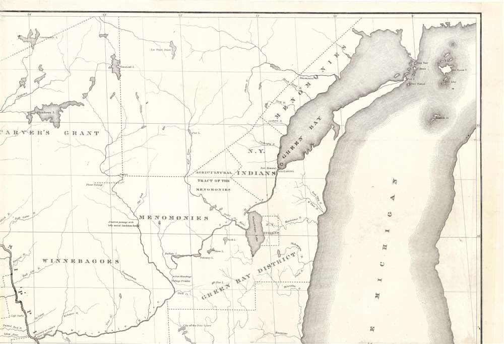
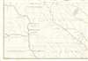
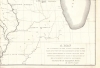
A Map of a Portion of the Indian Country Lying East and West of the Mississippi River to the Forty Sixth Degree of North Latitude from Personal Observation Made in the Autumn of 1835 and Recent Authentic Documents.
1836 (undated) 27.25 x 40 in (69.215 x 101.6 cm) 1 : 1013760
1836 (undated) 27.25 x 40 in (69.215 x 101.6 cm) 1 : 1013760
Description
FOR THE ORIGINAL ANTIQUE MAP, WITH HISTORICAL ANALYSIS, CLICK HERE.
Digital Map Information
Geographicus maintains an archive of high-resolution rare map scans. We scan our maps at 300 DPI or higher, with newer images being 600 DPI, (either TIFF or JPEG, depending on when the scan was done) which is most cases in suitable for enlargement and printing.
Delivery
Once you purchase our digital scan service, you will receive a download link via email - usually within seconds. Digital orders are delivered as ZIP files, an industry standard file compression protocol that any computer should be able to unpack. Some of our files are very large, and can take some time to download. Most files are saved into your computer's 'Downloads' folder. All delivery is electronic. No physical product is shipped.
Credit and Scope of Use
You can use your digial image any way you want! Our digital images are unrestricted by copyright and can be used, modified, and published freely. The textual description that accompanies the original antique map is not included in the sale of digital images and remains protected by copyright. That said, we put significant care and effort into scanning and editing these maps, and we’d appreciate a credit when possible. Should you wish to credit us, please use the following credit line:
Courtesy of Geographicus Rare Antique Maps (http://www.geographicus.com).
How Large Can I Print?
In general, at 300 DPI, you should at least be able to double the size of the actual image, more so with our 600 DPI images. So, if the original was 10 x 12 inches, you can print at 20 x 24 inches, without quality loss. If your display requirements can accommodate some loss in image quality, you can make it even larger. That being said, no quality of scan will allow you to blow up at 10 x 12 inch map to wall size without significant quality loss. For more information, it is best consult a printer or reprographics specialist.
Refunds
If the high resolution image you ordered is unavailable, we will fully refund your purchase. Otherwise, digital images scans are a service, not a tangible product, and cannot be returned or refunded once the download link is used.
Cartographer
George William Featherstonhaugh (April 9, 1780 - September 28, 1866) (pronounced Feer-sten-haw) was a British-American geologist and geographer. Born in London, Featherstonhaugh grew up in Scarborough in North Yorkshire. He went to the United States with the intention of studying indigenous languages in 1806. Two years later, on November 6, 1808, he married Sarah Duane in Schenectady, New York, with whom he had four children. During this time, he farmed and set up the first New York Board of Agriculture. Featherstonhaugh also began advocating for a railroad between the Hudson River at Albany and the Mohawk River at Schenectady. It took ten years for this plan to receive enough support, but Featherstonhaugh finally applied for a charter in December 1825, which was granted on April 17, 1826. Also in 1826, Featherstonhaugh's wife and two daughters died, which led him to sell his estate and moved to Philadelphia. Construction of the railroad began on July 29, 1830, and it opened on August 13, 1831. Featherstonhaugh remarried, to Charlotte Williams Carter, on January 28, 1831, with whom he had three children. In 1834, Featherstonhaugh was appointed the first U.S. government geologist. That year he left for St. Louis to survey parts of the Louisiana Purchase with his son George Jr. as his assistant. Featherstonhaugh travelled a large section of the upper Midwest from Green Bay, Wisconsin to the Wisconsin River and then downstream to Prairie du Chien, and then up the Mississippi to the Minnesota River. He travelled the Mississippi, Ohio, and Tennessee rivers in 1837, and then attended the Cherokee National Council in Red Clay, Tennessee. While ostensibly in the area to survey the mountainous regions in North Carolina and Georgia, Featherstonhaugh also spied on white people living with the Cherokee for the U.S. government. He and his family moved to England in 1838. Upon his return, Featherstonhaugh was appointed a commissioner to help settle the northern boundary dispute between the United States and Canada. After successfully solving the problem with the Webster-Ashburton Treaty, Featherstonhaugh was named consul from the British Government to the departments of Calvados and Seine, France. In this capacity, Featherstonhaugh almost single-handedly arranged and led the escape of the King and Queen of France to London after Louis Napoleon led a military coup against the King of France. More by this mapmaker...
References
Rumsey 13044.000. OCLC 26375167.