This copy is copyright protected.
Copyright © 2025 Geographicus Rare Antique Maps
Digital Image: 1825 Mexican Map of San Diego, California and San Blas, Mexico (by Guadalupe Victoria
SanDiego-victoria-1825_d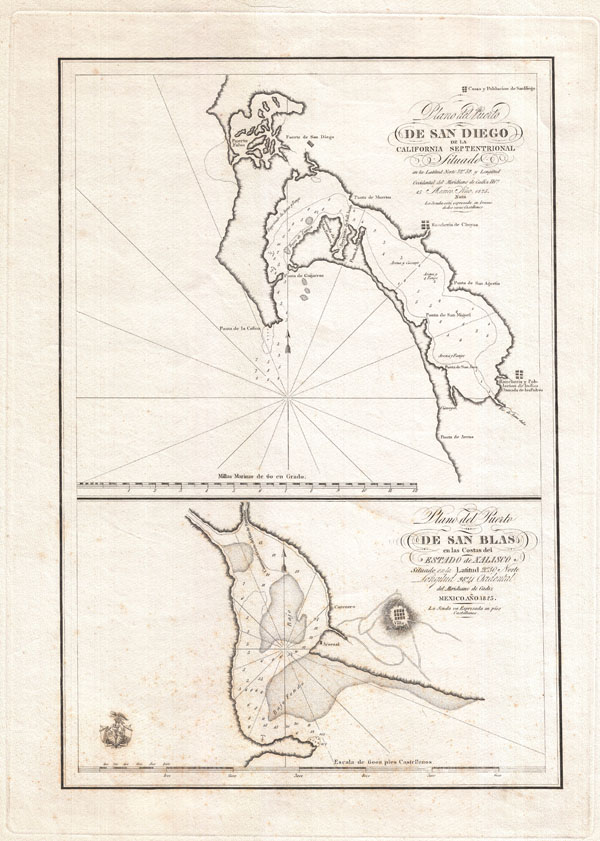

FOR THE ORIGINAL ANTIQUE MAP, WITH HISTORICAL ANALYSIS, CLICK HERE.
Digital Map Information
Geographicus maintains an archive of high-resolution rare map scans. We scan our maps at 300 DPI or higher, with newer images being 600 DPI, (either TIFF or JPEG, depending on when the scan was done) which is most cases in suitable for enlargement and printing.
Delivery
Once you purchase our digital scan service, you will receive a download link via email - usually within seconds. Digital orders are delivered as ZIP files, an industry standard file compression protocol that any computer should be able to unpack. Some of our files are very large, and can take some time to download. Most files are saved into your computer's 'Downloads' folder. All delivery is electronic. No physical product is shipped.
Credit and Scope of Use
You can use your digial image any way you want! Our digital images are unrestricted by copyright and can be used, modified, and published freely. The textual description that accompanies the original antique map is not included in the sale of digital images and remains protected by copyright. That said, we put significant care and effort into scanning and editing these maps, and we’d appreciate a credit when possible. Should you wish to credit us, please use the following credit line:
Courtesy of Geographicus Rare Antique Maps (http://www.geographicus.com).
How Large Can I Print?
In general, at 300 DPI, you should at least be able to double the size of the actual image, more so with our 600 DPI images. So, if the original was 10 x 12 inches, you can print at 20 x 24 inches, without quality loss. If your display requirements can accommodate some loss in image quality, you can make it even larger. That being said, no quality of scan will allow you to blow up at 10 x 12 inch map to wall size without significant quality loss. For more information, it is best consult a printer or reprographics specialist.
Refunds
If the high resolution image you ordered is unavailable, we will fully refund your purchase. Otherwise, digital images scans are a service, not a tangible product, and cannot be returned or refunded once the download link is used.
Guadalupe Victoria (September 29, 1786 - March 21, 1843) was a Mexican politician and revolutionary who fought for Mexican independence from Spain in the Mexican War of Independence. Following the War of Independence Victoria was elected the first president of Mexico. His political achievements as president of Mexico include the normalization of international diplomatic relations with Europe, the abolishment of slavery in Mexico, the creation of the National Museum, and formalized the Mexican-U.S. Border. Victoria was the only President who completed his full term in more than 30 years of an independent Mexico[10] He died in 1843 at the age of 58 from epilepsy in the fortress of Perote, where he was receiving medical treatment. On April 8, of the same year, it was decreed that his name would be written in golden letters in the session hall of the Chamber of Deputies. His mortal remains are interred, along with those of fellow Mexican heroes Miguel Hidalgo and Jose Maria Morelos, beneath El Ángel de la Independencia, a monument on the Paseo Reforma, Mexico City. More by this mapmaker...
Juan Pantoja y Arriaga (fl. c. 1779 - 1792) was a Mexican cartographer and navigator active in the late 18th century. Pantoja is best known for his work onboard the Frigate Princesa. The Princesa, of which Pantoja was the navigator, was a supply ship commissioned to make the annual supply run between the naval base of San Blas and Spain remote border fort, San Diego, along the California Coast. During a seven month lay-over in San Diego Pantoja produced his most famous map, the first reasonably accurate survey of San Diego Bay. Though composed in 1782, Pantoja's map remained in manuscript form until it was finally published in 1802 to illustrate Espinosa and Tello's Relacion Del Viage Hecho Por Las Goletas Sutil Y Mexicana En El Ano De 1792. Today Pantoja's efforts are commemorated in San Diego by Pantoja Park. Built in 1850, Pantoja Park is downtown San Diego's oldest public recreation area. Learn More...
Aaron Arrowsmith (1750-1823), John Arrowsmith (1790-1873), and Samuel Arrowsmith. The Arrowsmith family were noted map engravers, publishers, geographers, and cartographers active in the late 18th and early 19th century. The Arrowsmith firm was founded by Aaron Arrowsmith, who was trained in surveying and engraving under John Cary and William Faden. Arrowsmith founded the Arrowsmith firm as a side business while employed by Cary. The firm specialized in large format individual issue maps containing the most up to date and sophisticated information available. Arrowsmith's work drew the attention of the Prince of Wales who, in 1810, named him Hydrographer to the Prince of Wales, and subsequently, in 1820, Hydrographer to the King. Aaron Arrowsmith was succeeded by two sons, Aaron and Samuel, who followed him in the map publication business. The Arrowsmith firm eventually fell to John Arrowsmith (1790-1873), nephew of the elder Aaron. John was a founding member of the Royal Geographical Society. The firm is best known for their phenomenal large format mappings of North America. Mount Arrowsmith, situated east of Port Alberni on Vancouver Island, British Columbia, is named for Aaron Arrowsmith and his nephew John Arrowsmith. Learn More...
Copyright © 2025 Geographicus Rare Antique Maps | Geographicus Rare Antique Maps
This copy is copyright protected.
Copyright © 2025 Geographicus Rare Antique Maps