Digital Image: 1899 Pujol Rafting and Navigation Map of the Senegal River, Senegal
SenegalFleuve-pujol-1899_d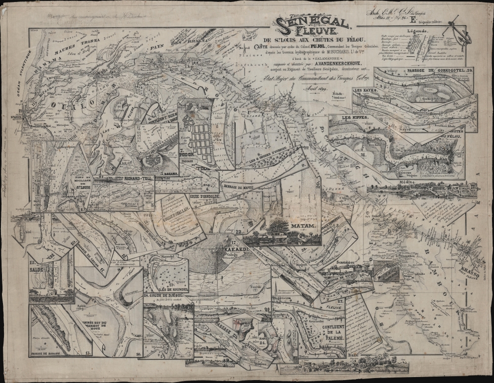

Title
Senegal Fleuve de St. Louis aux Chütes du Félou.
1899 (dated) 20 x 25 in (50.8 x 63.5 cm) 1 : 895000
1899 (dated) 20 x 25 in (50.8 x 63.5 cm) 1 : 895000
Description
FOR THE ORIGINAL ANTIQUE MAP, WITH HISTORICAL ANALYSIS, CLICK HERE.
Digital Map Information
Geographicus maintains an archive of high-resolution rare map scans. We scan our maps at 300 DPI or higher, with newer images being 600 DPI, (either TIFF or JPEG, depending on when the scan was done) which is most cases in suitable for enlargement and printing.
Delivery
Once you purchase our digital scan service, you will receive a download link via email - usually within seconds. Digital orders are delivered as ZIP files, an industry standard file compression protocol that any computer should be able to unpack. Some of our files are very large, and can take some time to download. Most files are saved into your computer's 'Downloads' folder. All delivery is electronic. No physical product is shipped.
Credit and Scope of Use
You can use your digial image any way you want! Our digital images are unrestricted by copyright and can be used, modified, and published freely. The textual description that accompanies the original antique map is not included in the sale of digital images and remains protected by copyright. That said, we put significant care and effort into scanning and editing these maps, and we’d appreciate a credit when possible. Should you wish to credit us, please use the following credit line:
Courtesy of Geographicus Rare Antique Maps (http://www.geographicus.com).
How Large Can I Print?
In general, at 300 DPI, you should at least be able to double the size of the actual image, more so with our 600 DPI images. So, if the original was 10 x 12 inches, you can print at 20 x 24 inches, without quality loss. If your display requirements can accommodate some loss in image quality, you can make it even larger. That being said, no quality of scan will allow you to blow up at 10 x 12 inch map to wall size without significant quality loss. For more information, it is best consult a printer or reprographics specialist.
Refunds
If the high resolution image you ordered is unavailable, we will fully refund your purchase. Otherwise, digital images scans are a service, not a tangible product, and cannot be returned or refunded once the download link is used.
Cartographer S
August Marie Joseph Pujol (March 4, 1863 - 19xx) was a French colonial officer born in the Cammarges, France. He served in various posts from about 1880 to 1899, including Toulon (1885), Reunion (1885), Madagascar (1886), Senegal (1890), Sudan (1892), and Tonkin (1893 - 1903). In Senegal he held the rank of Etat-Major du Commandant Superior des Troupes Coloniales. The only definitive reference we have found to his service is an 1887 dispatch on the excessive rates of venereal disease among French African soldiers. More by this mapmaker...
Henri Pierre Gabriel Buchard (November 28, 1854 - c. 1941) was a French colonial naval officer and hydrographer. Buchard was born in Châtillon-sur-Seine, France, and studied at the École Navale, graduating in 1872. He is best known for commanding the Salamandre (1891) and Mésange (1894) and his 1891 - 1893 mapping the Senegal River. He was made an Officier de la Légion d'Honneur in 1906. Learn More...