This copy is copyright protected.
Copyright © 2025 Geographicus Rare Antique Maps
Digital Image: 1928 Stanford Map of Shanghai, Foreign Concessions
ShanghaiPlan-stanford-1928_d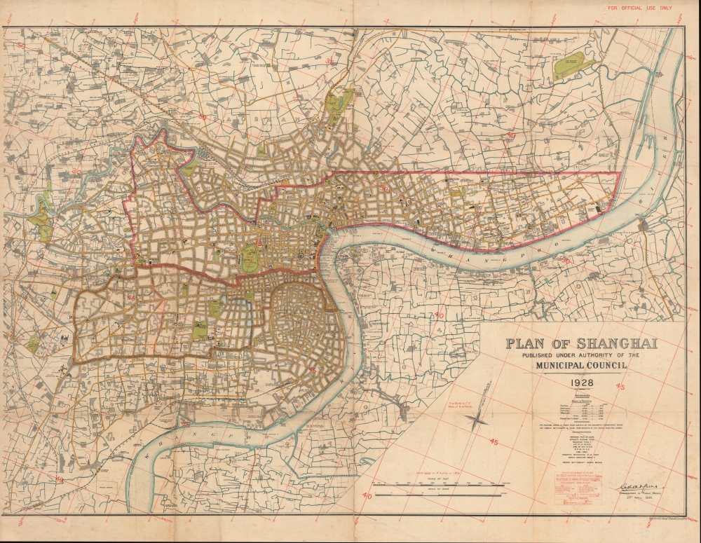


FOR THE ORIGINAL ANTIQUE MAP, WITH HISTORICAL ANALYSIS, CLICK HERE.
Digital Map Information
Geographicus maintains an archive of high-resolution rare map scans. We scan our maps at 300 DPI or higher, with newer images being 600 DPI, (either TIFF or JPEG, depending on when the scan was done) which is most cases in suitable for enlargement and printing.
Delivery
Once you purchase our digital scan service, you will receive a download link via email - usually within seconds. Digital orders are delivered as ZIP files, an industry standard file compression protocol that any computer should be able to unpack. Some of our files are very large, and can take some time to download. Most files are saved into your computer's 'Downloads' folder. All delivery is electronic. No physical product is shipped.
Credit and Scope of Use
You can use your digial image any way you want! Our digital images are unrestricted by copyright and can be used, modified, and published freely. The textual description that accompanies the original antique map is not included in the sale of digital images and remains protected by copyright. That said, we put significant care and effort into scanning and editing these maps, and we’d appreciate a credit when possible. Should you wish to credit us, please use the following credit line:
Courtesy of Geographicus Rare Antique Maps (http://www.geographicus.com).
How Large Can I Print?
In general, at 300 DPI, you should at least be able to double the size of the actual image, more so with our 600 DPI images. So, if the original was 10 x 12 inches, you can print at 20 x 24 inches, without quality loss. If your display requirements can accommodate some loss in image quality, you can make it even larger. That being said, no quality of scan will allow you to blow up at 10 x 12 inch map to wall size without significant quality loss. For more information, it is best consult a printer or reprographics specialist.
Refunds
If the high resolution image you ordered is unavailable, we will fully refund your purchase. Otherwise, digital images scans are a service, not a tangible product, and cannot be returned or refunded once the download link is used.
Edward Stanford (May 27, 1827 - November 3, 1904) was one of the most prolific map publishing firms of the late 19th century. The company began as a partnership in 1848 between the 21 year old Edward Stanford and the established map dealer Trelawney Saunders. By 1853 the partnership had dissolved and Edward Stanford took full control of the business. A subsequent series of expansions and exciting new map issues finally led to the production of Stanford's masterwork, "Stanford's Library Map of London". This map is still available and remains somewhat accurate. At the time of publishing it was hailed by the Royal Geographical Society as "the most perfect map of London that has ever been issued". In 1882 Edward Stanford Sr. passed the firm on to his son, Edward Stanford Jr. who continued in his father's proud tradition. Today the Stanford firm still publishes maps and remains one of the most important and prolific cartographic publishers in the world. More by this mapmaker...
Shanghai Municipal Council (July 11, 1854 - 1943) was an organization of businessmen leaders in Shanghai active from middle part of the 19th century to the early 20th century. The organization was formed on July 11, 1854 by a group of influential western businessmen who argued that Shanghai suffered under a lack of proper municipal governance. It laid down land regulations and began to assist in the construction of new roads, established refuse collection, and even initiated taxation. By the late-1860s Shanghai's official governing body had been practically transferred from the individual concessions to the Shanghai Municipal Council (工部局). The British Consul was the de jure authority in the Settlement, but he had no actual power unless the ratepayers (who voted for the council) agreed. Instead, he and the other consulates deferred to the Council, which was made of 9 figures, 5 from the British Settlement, 2 form the American Settlement, and 2 from the Japanese Settlement. No Chinese were permitted to serve on the council until 1928. By the 1880s the council acquired a virtual monopoly over city utilities, controlling gas-suppliers, electricity producers and water-companies. Later, in the early 20th century, they also took control of rickshaws, tramways, and regulated opium sales and prostitution. The council maintained its own police force, fire service, and military reserve, the Shanghai Volunteer Corps (萬國商團). The Municipal Council was disbanded in 1943, in World War II, when the Japanese closed all foreign concessions (except the French). Learn More...
Copyright © 2025 Geographicus Rare Antique Maps | Geographicus Rare Antique Maps
This copy is copyright protected.
Copyright © 2025 Geographicus Rare Antique Maps