This copy is copyright protected.
Copyright © 2025 Geographicus Rare Antique Maps
Digital Image: 1828 Jackson / Crawfurd Map of Singapore - first map of Singapore!
Singapore-jackson-1828-3_d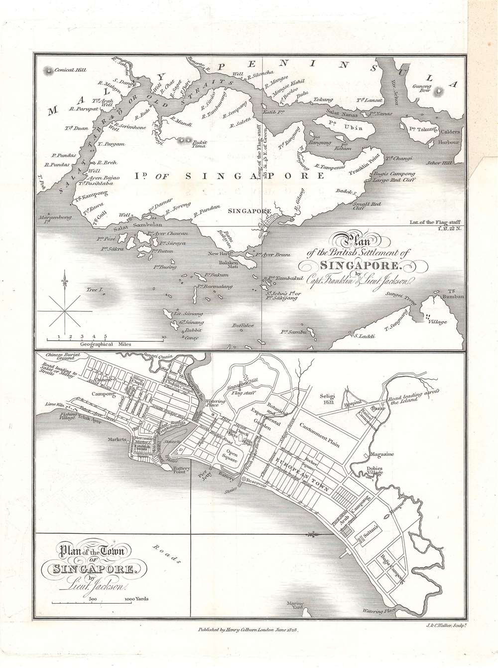

FOR THE ORIGINAL ANTIQUE MAP, WITH HISTORICAL ANALYSIS, CLICK HERE.
Digital Map Information
Geographicus maintains an archive of high-resolution rare map scans. We scan our maps at 300 DPI or higher, with newer images being 600 DPI, (either TIFF or JPEG, depending on when the scan was done) which is most cases in suitable for enlargement and printing.
Delivery
Once you purchase our digital scan service, you will receive a download link via email - usually within seconds. Digital orders are delivered as ZIP files, an industry standard file compression protocol that any computer should be able to unpack. Some of our files are very large, and can take some time to download. Most files are saved into your computer's 'Downloads' folder. All delivery is electronic. No physical product is shipped.
Credit and Scope of Use
You can use your digial image any way you want! Our digital images are unrestricted by copyright and can be used, modified, and published freely. The textual description that accompanies the original antique map is not included in the sale of digital images and remains protected by copyright. That said, we put significant care and effort into scanning and editing these maps, and we’d appreciate a credit when possible. Should you wish to credit us, please use the following credit line:
Courtesy of Geographicus Rare Antique Maps (http://www.geographicus.com).
How Large Can I Print?
In general, at 300 DPI, you should at least be able to double the size of the actual image, more so with our 600 DPI images. So, if the original was 10 x 12 inches, you can print at 20 x 24 inches, without quality loss. If your display requirements can accommodate some loss in image quality, you can make it even larger. That being said, no quality of scan will allow you to blow up at 10 x 12 inch map to wall size without significant quality loss. For more information, it is best consult a printer or reprographics specialist.
Refunds
If the high resolution image you ordered is unavailable, we will fully refund your purchase. Otherwise, digital images scans are a service, not a tangible product, and cannot be returned or refunded once the download link is used.
Philip Jackson (September 24, 1802 - 1879) was a British naval officer, surveyor, and engineer active in the early settlement and planning of Singapore. Jackson was born in Durham and joined the East India Company army at 16. He traveled to India with the Bengal Artillery Regiment and was subsequently posted to Singapore in January of 1822. Leveraging Jacksons experience as a surveyor and engineer, Singapore founder Stamford Raffles appointed him Assistant Engineer on October 29 of 1922. Jackson was tasked with realizing Raffles vision for the design and layout of Singapore and is credited with the first map of Singapore, published in 1828. Jackson was appointed surveyor of Singapore's public lands in February of 1826. More by this mapmaker...
John Walker (1787 - April 19, 1873) was a British map seller, engraver, lithographer, hydrographer, geographer, draughtsman, and publisher active in London during the 19th century. Walker published both nautical charts and geographical maps. His nautical work is particularly distinguished as he was an official hydrographer for the British East India Company, a position, incidentally, also held by his father of the same name. Walker's maps, mostly published after 1827, were primarily produced with his brothers Charles Walker and Alexander Walker under the imprint J. and C. Walker. Among their joint projects are more than 200 maps for the influential Society for the Diffusion of Useful Knowledge Atlas (SDUK). In addition they published numerous charts for James Horsburgh and the British Admiralty Hydrographic Office, including Belcher's important map of Hong Kong and Carless' exploratory map of Karachi. The J. and C. Walker firm continued to publish after both Walkers died in the 1870s. Learn More...
Henry Colburn (1784 - August 16, 1855) was a British publisher. Colburn started off in the publishing profession in the Albemarle Street shop of William Earle, a bookseller in London. His next move was to become an assistant at a circulating library on Conduit Street called Morgan's Library, which he took over in 1816. Eventually he signed this business over to Messrs. Saunders and Otley and opened his own publishing firm. He gained initial success with the roman à clef novel Glenavron by Lady Caroline Lamb and which was published in 1816. It went through four editions and sold well. Colburn later expanded on the success of Glenavron and published a series of so-called 'Silver Fork Novels', a series of books that afforded readers the thrill of peering into the lives of rich and aristocratic families. Colburn also started several periodicals, including the New Monthly Magazine, the Literary Gazette, the earliest weekly newspaper dedicated to literature, science, and the arts. Colburn married twice. His second marriage was to Eliza Anne, who survived him. Learn More...
Copyright © 2025 Geographicus Rare Antique Maps | Geographicus Rare Antique Maps
This copy is copyright protected.
Copyright © 2025 Geographicus Rare Antique Maps