Digital Image: 1934 Pruett Pictorial Map of Texas History, Celebrating Its Centennial
TexasHistory-pruett-1934_d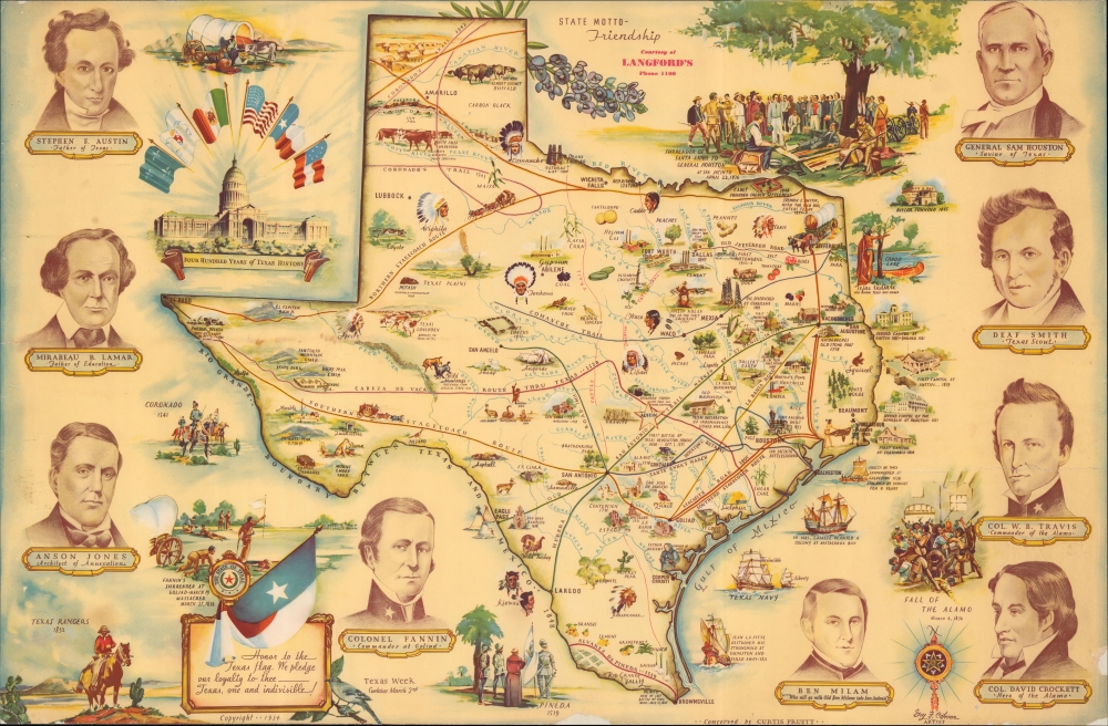


Title
Four Hundred Years of Texas History.
1934 (dated) 19.75 x 30.25 in (50.165 x 76.835 cm)
1934 (dated) 19.75 x 30.25 in (50.165 x 76.835 cm)
Description
FOR THE ORIGINAL ANTIQUE MAP, WITH HISTORICAL ANALYSIS, CLICK HERE.
Digital Map Information
Geographicus maintains an archive of high-resolution rare map scans. We scan our maps at 300 DPI or higher, with newer images being 600 DPI, (either TIFF or JPEG, depending on when the scan was done) which is most cases in suitable for enlargement and printing.
Delivery
Once you purchase our digital scan service, you will receive a download link via email - usually within seconds. Digital orders are delivered as ZIP files, an industry standard file compression protocol that any computer should be able to unpack. Some of our files are very large, and can take some time to download. Most files are saved into your computer's 'Downloads' folder. All delivery is electronic. No physical product is shipped.
Credit and Scope of Use
You can use your digial image any way you want! Our digital images are unrestricted by copyright and can be used, modified, and published freely. The textual description that accompanies the original antique map is not included in the sale of digital images and remains protected by copyright. That said, we put significant care and effort into scanning and editing these maps, and we’d appreciate a credit when possible. Should you wish to credit us, please use the following credit line:
Courtesy of Geographicus Rare Antique Maps (http://www.geographicus.com).
How Large Can I Print?
In general, at 300 DPI, you should at least be able to double the size of the actual image, more so with our 600 DPI images. So, if the original was 10 x 12 inches, you can print at 20 x 24 inches, without quality loss. If your display requirements can accommodate some loss in image quality, you can make it even larger. That being said, no quality of scan will allow you to blow up at 10 x 12 inch map to wall size without significant quality loss. For more information, it is best consult a printer or reprographics specialist.
Refunds
If the high resolution image you ordered is unavailable, we will fully refund your purchase. Otherwise, digital images scans are a service, not a tangible product, and cannot be returned or refunded once the download link is used.
Cartographer S
Cahoon, Guy Forsythe (c. 1899 - 1971) was an artist based in Dallas, Texas. He was born in Illinois, but little else is known of his early life and training. By 1912, he began appearing in Dallas city directories as a draughtsman or commercial artist, and continued to do so until the early 1970s. He also appears to have designed some homes. In terms of publications, he was most active in the 1930s, producing illustrated works on local history and culture, as well as a textbook of sorts titled Commercial Art. His cartographic output includes 'The Official Centennial Map of Texas' (1934) and a later 'Historical Map of Texas' (1967), which may be a later reprint of the former, both for the Daughters of the Texas Revolution. More by this mapmaker...
Curtis D. Pruett (fl. c. 1925 - 1967), sometimes as Curtis B. Pruett, was an artist and art shop owner in Dallas, Texas. He appears in Dallas city directories as an artist as early as 1925, and was also occasionally referred to as a 'display architect.' Little is known about his life and work aside from his involvement with 'The Official Centennial Map of Texas' (1934) and a later 'Historical Map of Texas' (1967), which may be a later reprint of the former, both for the Daughters of the Texas Revolution. Learn More...
References
OCLC 310361940. Texas State Library and Archives Call. No. 976.4062 G123t.