This copy is copyright protected.
Copyright © 2025 Geographicus Rare Antique Maps
Digital Image: 1899 French Bureau Topographique Map of Tonkin, Indochina, North Vietnam
TonkinVietnam-topographique-1899_d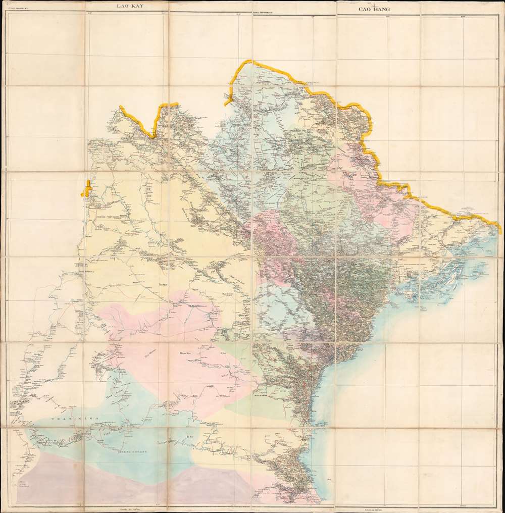


FOR THE ORIGINAL ANTIQUE MAP, WITH HISTORICAL ANALYSIS, CLICK HERE.
Digital Map Information
Geographicus maintains an archive of high-resolution rare map scans. We scan our maps at 300 DPI or higher, with newer images being 600 DPI, (either TIFF or JPEG, depending on when the scan was done) which is most cases in suitable for enlargement and printing.
Delivery
Once you purchase our digital scan service, you will receive a download link via email - usually within seconds. Digital orders are delivered as ZIP files, an industry standard file compression protocol that any computer should be able to unpack. Some of our files are very large, and can take some time to download. Most files are saved into your computer's 'Downloads' folder. All delivery is electronic. No physical product is shipped.
Credit and Scope of Use
You can use your digial image any way you want! Our digital images are unrestricted by copyright and can be used, modified, and published freely. The textual description that accompanies the original antique map is not included in the sale of digital images and remains protected by copyright. That said, we put significant care and effort into scanning and editing these maps, and we’d appreciate a credit when possible. Should you wish to credit us, please use the following credit line:
Courtesy of Geographicus Rare Antique Maps (http://www.geographicus.com).
How Large Can I Print?
In general, at 300 DPI, you should at least be able to double the size of the actual image, more so with our 600 DPI images. So, if the original was 10 x 12 inches, you can print at 20 x 24 inches, without quality loss. If your display requirements can accommodate some loss in image quality, you can make it even larger. That being said, no quality of scan will allow you to blow up at 10 x 12 inch map to wall size without significant quality loss. For more information, it is best consult a printer or reprographics specialist.
Refunds
If the high resolution image you ordered is unavailable, we will fully refund your purchase. Otherwise, digital images scans are a service, not a tangible product, and cannot be returned or refunded once the download link is used.
Bureau Topographique des Troupes de l'Indo-chine (fl. c. 1886 - 1900) was founded in 1886 in Hanoi. Its first major project was a 1:2000000 map of the entirety of Indochina, for which they drew on source maps created by the Service Hydrographique de la Marine and those created by an expeditionary corps sent throughout the region. Before establishing its own printing facilities in Indochina in 1890, the Bureau Topographique transferred their work back to Paris to be printed by the Service Géographique de l'Armée. In 1890 the Bureau Topographique also began to increase its cartographic output. The Bureau Topographique sent army officers on triangulation and topographic missions in unexplored areas of Indochina throughout the 1890s, some of which proved fatal for the participants. It is unclear when the Bureau Topographique shut down, but no examples of their work postdate 1900. More by this mapmaker...
Copyright © 2025 Geographicus Rare Antique Maps | Geographicus Rare Antique Maps
This copy is copyright protected.
Copyright © 2025 Geographicus Rare Antique Maps