This copy is copyright protected.
Copyright © 2025 Geographicus Rare Antique Maps
Digital Image: 1801 Cary Map of Turkey in Europe, Greece, and the Balkan
TurkeyEurope-cary-1801_d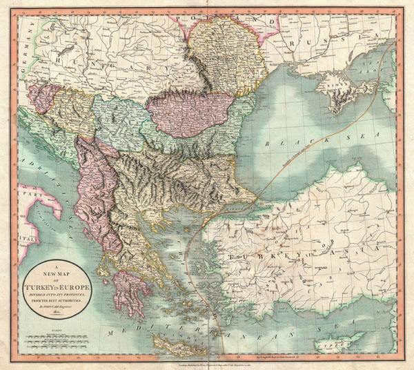

FOR THE ORIGINAL ANTIQUE MAP, WITH HISTORICAL ANALYSIS, CLICK HERE.
Digital Map Information
Geographicus maintains an archive of high-resolution rare map scans. We scan our maps at 300 DPI or higher, with newer images being 600 DPI, (either TIFF or JPEG, depending on when the scan was done) which is most cases in suitable for enlargement and printing.
Delivery
Once you purchase our digital scan service, you will receive a download link via email - usually within seconds. Digital orders are delivered as ZIP files, an industry standard file compression protocol that any computer should be able to unpack. Some of our files are very large, and can take some time to download. Most files are saved into your computer's 'Downloads' folder. All delivery is electronic. No physical product is shipped.
Credit and Scope of Use
You can use your digial image any way you want! Our digital images are unrestricted by copyright and can be used, modified, and published freely. The textual description that accompanies the original antique map is not included in the sale of digital images and remains protected by copyright. That said, we put significant care and effort into scanning and editing these maps, and we’d appreciate a credit when possible. Should you wish to credit us, please use the following credit line:
Courtesy of Geographicus Rare Antique Maps (http://www.geographicus.com).
How Large Can I Print?
In general, at 300 DPI, you should at least be able to double the size of the actual image, more so with our 600 DPI images. So, if the original was 10 x 12 inches, you can print at 20 x 24 inches, without quality loss. If your display requirements can accommodate some loss in image quality, you can make it even larger. That being said, no quality of scan will allow you to blow up at 10 x 12 inch map to wall size without significant quality loss. For more information, it is best consult a printer or reprographics specialist.
Refunds
If the high resolution image you ordered is unavailable, we will fully refund your purchase. Otherwise, digital images scans are a service, not a tangible product, and cannot be returned or refunded once the download link is used.
John Cary (1754 - 1835) was a London based cartographer active in the early part of the 19th century. Ronald Vere Tooley, the prominent English map historian, writes of Cary, "As an engraver he was elegant and exact with fine clear lettering and great delicacy of touch." Cary began his work as an engraver, cartographer, and globe maker in 1776 with his New and Correct English Atlas. This important atlas represented a new phase in cartography where accuracy and detail rose in prominence over the decorative embellishments of the 18th century. This change was indicative of the times when travel and commerce were expanding globally as never before. Cary's mastery of both engraving and cartography resulted in a series of seminal works that redefined mapmaking in the early 19th century. His stupendous Cary's New Universal Atlas, published in 1808, set the standard for all cartographers who followed. Cary reissued this seminal atlas in 1811, 1819, 1824, 1828, 1833, 1836 and 1844. Cary also did considerable work on the English Ordinance Survey prior to 1805. His cartographic work particularly inspired the Edinburgh school of cartography as represented by John Pinkerton and John Thomson. In America, Cary's work was used as the basis for Tanner's important New American Atlas. Cary's last published atlas appeared posthumously in 1844, however, by 1850 Cary's work was being carried on by his sons and other well-known cartographers including James Wyld, John Tallis & Company, and Crutchley. More by this mapmaker...
Copyright © 2025 Geographicus Rare Antique Maps | Geographicus Rare Antique Maps
This copy is copyright protected.
Copyright © 2025 Geographicus Rare Antique Maps