This copy is copyright protected.
Copyright © 2025 Geographicus Rare Antique Maps
Digital Image: 1820 Warner Pocket Map of the United States
UnitedStates-warner-1820-2_d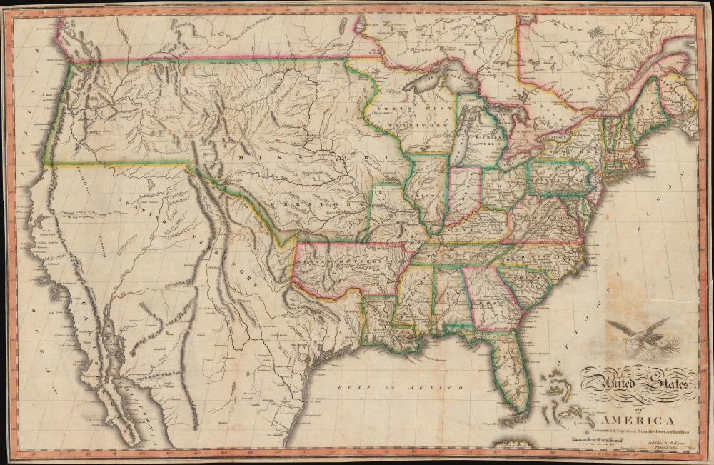

FOR THE ORIGINAL ANTIQUE MAP, WITH HISTORICAL ANALYSIS, CLICK HERE.
Digital Map Information
Geographicus maintains an archive of high-resolution rare map scans. We scan our maps at 300 DPI or higher, with newer images being 600 DPI, (either TIFF or JPEG, depending on when the scan was done) which is most cases in suitable for enlargement and printing.
Delivery
Once you purchase our digital scan service, you will receive a download link via email - usually within seconds. Digital orders are delivered as ZIP files, an industry standard file compression protocol that any computer should be able to unpack. Some of our files are very large, and can take some time to download. Most files are saved into your computer's 'Downloads' folder. All delivery is electronic. No physical product is shipped.
Credit and Scope of Use
You can use your digial image any way you want! Our digital images are unrestricted by copyright and can be used, modified, and published freely. The textual description that accompanies the original antique map is not included in the sale of digital images and remains protected by copyright. That said, we put significant care and effort into scanning and editing these maps, and we’d appreciate a credit when possible. Should you wish to credit us, please use the following credit line:
Courtesy of Geographicus Rare Antique Maps (http://www.geographicus.com).
How Large Can I Print?
In general, at 300 DPI, you should at least be able to double the size of the actual image, more so with our 600 DPI images. So, if the original was 10 x 12 inches, you can print at 20 x 24 inches, without quality loss. If your display requirements can accommodate some loss in image quality, you can make it even larger. That being said, no quality of scan will allow you to blow up at 10 x 12 inch map to wall size without significant quality loss. For more information, it is best consult a printer or reprographics specialist.
Refunds
If the high resolution image you ordered is unavailable, we will fully refund your purchase. Otherwise, digital images scans are a service, not a tangible product, and cannot be returned or refunded once the download link is used.
Benjamin Warner (fl. c. 1800 - 1830) was an American bookseller and publisher based in Philadelphia during the first half of the 19th century. Waner was a Pennsylvania Quaker who partnered with Jacob Johnson, a bookseller, printer, and inkmaker to produce numerous imprints. He maintained a location at 147 High Street (147 Market St) Philadelphia, as well as shops in Richmond, Virginia and Charleston, South Carolina. His apprentices included John Grigg, later known for medical imprints. More by this mapmaker...
Hugh Anderson (c. 1790 - 1854, fl. 1811 - 1854) was an American line and stipple engraver based in Philadelphia, PA. Anderson was not specifically a cartographic engraver and his corpus includes landscape views, allegorical images, frontispieces, architectural, anatomical, and animal engravings, as well as maps. His name appears in Philadelphia directories from 1811 to 1819 and again from 1822 to 1824. Anderson was most likely Scottish and probably trained in Scotland before immigrating to the United States. There is some suggestion that Anderson was also a watchmaker and that he relocated to Ohio, where he may have continued his business and even engaged in politics under the Democratic Party. His apprentices may have included John Hugh Williams of Iowa (his son in law) and Genin Sylvester of Ohio. Learn More...
Copyright © 2025 Geographicus Rare Antique Maps | Geographicus Rare Antique Maps
This copy is copyright protected.
Copyright © 2025 Geographicus Rare Antique Maps