This copy is copyright protected.
Copyright © 2025 Geographicus Rare Antique Maps
Digital Image: 1907 Berthrong / Bond Map of the United States w/ Roads and Exploration
UnitedStatesExploration-berthrong-1907_d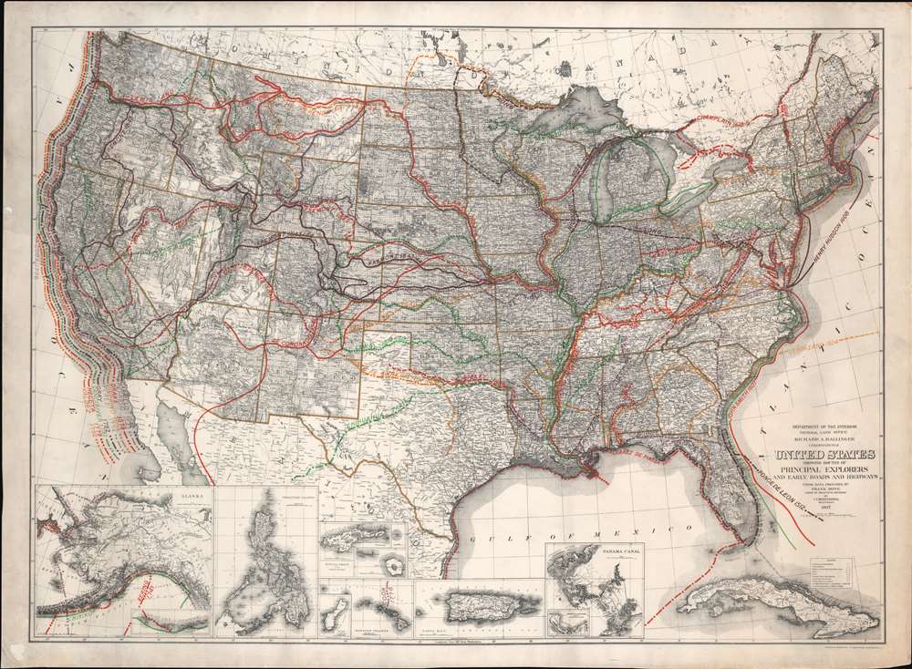

FOR THE ORIGINAL ANTIQUE MAP, WITH HISTORICAL ANALYSIS, CLICK HERE.
Digital Map Information
Geographicus maintains an archive of high-resolution rare map scans. We scan our maps at 300 DPI or higher, with newer images being 600 DPI, (either TIFF or JPEG, depending on when the scan was done) which is most cases in suitable for enlargement and printing.
Delivery
Once you purchase our digital scan service, you will receive a download link via email - usually within seconds. Digital orders are delivered as ZIP files, an industry standard file compression protocol that any computer should be able to unpack. Some of our files are very large, and can take some time to download. Most files are saved into your computer's 'Downloads' folder. All delivery is electronic. No physical product is shipped.
Credit and Scope of Use
You can use your digial image any way you want! Our digital images are unrestricted by copyright and can be used, modified, and published freely. The textual description that accompanies the original antique map is not included in the sale of digital images and remains protected by copyright. That said, we put significant care and effort into scanning and editing these maps, and we’d appreciate a credit when possible. Should you wish to credit us, please use the following credit line:
Courtesy of Geographicus Rare Antique Maps (http://www.geographicus.com).
How Large Can I Print?
In general, at 300 DPI, you should at least be able to double the size of the actual image, more so with our 600 DPI images. So, if the original was 10 x 12 inches, you can print at 20 x 24 inches, without quality loss. If your display requirements can accommodate some loss in image quality, you can make it even larger. That being said, no quality of scan will allow you to blow up at 10 x 12 inch map to wall size without significant quality loss. For more information, it is best consult a printer or reprographics specialist.
Refunds
If the high resolution image you ordered is unavailable, we will fully refund your purchase. Otherwise, digital images scans are a service, not a tangible product, and cannot be returned or refunded once the download link is used.
Ithamar Parsons Berthrong (February 26, 1853 - July 29, 1936) was an American surveyor, inventor, and draftsman active with the General Land Office of the U.S. Department of the Interior. Berthrong was born in Rochester, New York. He was made chief of the drafting division on March 23 of 1907. He is associated with many of the most important early 20th century maps issued by the GLO, among them, important maps of Arizona, Colorado, Wyoming, Oregon, Washington, and more. More by this mapmaker...
Frank Bond (1856 - 1940) was an American cartographer, draftsman, surveyor, illustrator, and politician. Born in rural Jones County, Iowa, Bond graduated from the University of Iowa. In 1772, he moved to Cheyenne Wyoming, where he worked for the Wyoming Surveyor-General's Office and later the General Land Office as a draftsman. He left this position to edit the Cheyenne Tribute and engage in local politics. Bond was elected as a member of the first Wyoming legislature. In 1900, he moved to Washington, D.C., where he held the positions of Chief of the Drafting Division and Chief Clerk at the General Land Office. While at the Land Office, Bond helped determine the borders of Yosemite National Park . As a skilled mapmaker and illustrator, Bond created numerous maps. He was also an active illustrator, painter and ornithologist, creating and preserving bird refuges throughout the country. He had a twin brother, Fred Bond, was also an important surveyor and draftsman. Learn More...
The General Land Office (GLO) (1812 - 1946) was an independent agency of the United States government responsible for public domain lands in the United States. Created in 1812, it took over functions previously conducted by the Department of the Treasury. The GLO oversaw the surveying, platting, and sale of public lands in the western United States. It also administered the Preemption Act of 1841, which allowed individuals who were already living on federal land to purchase up to 160 acres of land before it was offered for sale to the general public, if they met certain requirements. Following the passage of the Homestead Act in 1862, which was also administered by the GLO, claims under the Preemption Act sharply decreased. The GLO became a part of the newly-created Department of the Interior in 1849. In 1891 Grover Cleveland and Congress created 17 forest reserves, due to public concern over forest conservation, which were initially managed by the GLO, until they were transferred to the Forest Service in 1905. In 1946 the Government Land Office was merged with the United States Grazing Service to become the Bureau of Land Management. Today the Bureau of Land Management administers the roughly 246 million acres of public land remaining under federal ownership. Learn More...
Andrew B. Graham (1845 - September 9, 1909) was an American lithographer active in Washington, D.C. in late 19th and early 20th century. Graham was born in Washington D.C., the son of a lithographer and engraver. After college, he joined the U.S. Coast Survey, where he was a draftsman until 1889. He retired from the Coast Survey to take over management of his father's lithography firm. The firm, Andrew B. Graham Company, was one of several that thrived on lucrative government publication contracts. Graham died of 'brain fever' in his Washington D. C. residence on September 9 of 1909. Some of his work was republished posthumously until about 1917, and his firm was active until at least the early 1920s. Learn More...
Copyright © 2025 Geographicus Rare Antique Maps | Geographicus Rare Antique Maps
This copy is copyright protected.
Copyright © 2025 Geographicus Rare Antique Maps