This copy is copyright protected.
Copyright © 2025 Geographicus Rare Antique Maps
Digital Image: 1880 Brault Map of Pacific Ocean Winds in July, August, and September
VentPacifiqueJuilSept-brault-1880_d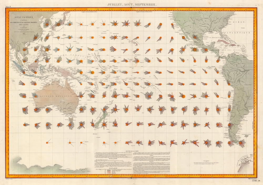

FOR THE ORIGINAL ANTIQUE MAP, WITH HISTORICAL ANALYSIS, CLICK HERE.
Digital Map Information
Geographicus maintains an archive of high-resolution rare map scans. We scan our maps at 300 DPI or higher, with newer images being 600 DPI, (either TIFF or JPEG, depending on when the scan was done) which is most cases in suitable for enlargement and printing.
Delivery
Once you purchase our digital scan service, you will receive a download link via email - usually within seconds. Digital orders are delivered as ZIP files, an industry standard file compression protocol that any computer should be able to unpack. Some of our files are very large, and can take some time to download. Most files are saved into your computer's 'Downloads' folder. All delivery is electronic. No physical product is shipped.
Credit and Scope of Use
You can use your digial image any way you want! Our digital images are unrestricted by copyright and can be used, modified, and published freely. The textual description that accompanies the original antique map is not included in the sale of digital images and remains protected by copyright. That said, we put significant care and effort into scanning and editing these maps, and we’d appreciate a credit when possible. Should you wish to credit us, please use the following credit line:
Courtesy of Geographicus Rare Antique Maps (http://www.geographicus.com).
How Large Can I Print?
In general, at 300 DPI, you should at least be able to double the size of the actual image, more so with our 600 DPI images. So, if the original was 10 x 12 inches, you can print at 20 x 24 inches, without quality loss. If your display requirements can accommodate some loss in image quality, you can make it even larger. That being said, no quality of scan will allow you to blow up at 10 x 12 inch map to wall size without significant quality loss. For more information, it is best consult a printer or reprographics specialist.
Refunds
If the high resolution image you ordered is unavailable, we will fully refund your purchase. Otherwise, digital images scans are a service, not a tangible product, and cannot be returned or refunded once the download link is used.
Louis Désiré Léon Brault (January 7, 1839 - August 27, 1885) was a French naval officer, meteorologist, and cartographer. Born in Vendôme, he attended the École Polytechnique beginning in 1859. He joined the French Navy in 1861, eventually rising to the rank of capitaine de frégate. He fell ill from dysentery in 1868, and during his convalescence began contemplating how wind is represented on maps. With this new fascination in mind, he requested a transfer to the Dépôt des cartes et plans de la Marine, which was granted. He began working at the Dépôt on March 17, 1869, but, after the French declaration of war beginning the Franco-Prussian War, Brault requested to be sent back to sea. He was assigned to the Invincible, an ironclad frigate. A recurrence of dysentery forced him to convalesce for the entirety of 1871. After regaining his health in January 1872, Brault asked to be reassigned to the Dépôt des cartes to finish his work on the wind maps. In 1874 Brault published the first set of wind map, a set of our maps of seasonal winds of the North Atlantic. He was named the Director of Meteorology at the Dépôt des cartes in 1878, a post he held until his death. Brault also published several books, including Traité d'astronomie et de la météorologie appliquées à la navigation. Brault eventually created wind maps for the Pacific, North Atlantic, South Atlantic, and Indian Oceans. More by this mapmaker...
Ernest Dumas-Vorzet (18?? - 18??) was a French line and letter engraver active in Paris in the late 19th century. He engraved the lettering on nautical charts for the Dépôt des Cartes et Plans de la Marine. His later work is often associated with Émile Delaune (18?? - 19??) and Hachette et Cie. He is likely the father of Edouard Dumas-Vorzet, a French publisher and cartographer. Learn More...
Dépôt des Cartes et Plans de la Marine (fl. 1720 - present), often called the Dépôt de Marine, was a French hydrographic mapping organization founded in 1720 under Charles-Hercule of Albert de Luynes (1674 - 1734). Much like the U.S. Coast Survey, the British Admiralty, and the Spanish Deposito Hydrografico, the Dépôt was initiated as a storehouse and distribution center of existing nautical and marine charts. Eventually the Dépôt initiated its own mapping activities in an attempt to improve and expand upon existing material. Some of the more prominent cartographers and hydrographers associated with the of Dépôt des Cartes were, Philippe Buache, Jacques-Nicholas Bellin, Giovanni Rizzi-Zannoni, Rigobert Bonne, and Jean Nicolas Buache. Learn More...
Copyright © 2025 Geographicus Rare Antique Maps | Geographicus Rare Antique Maps
This copy is copyright protected.
Copyright © 2025 Geographicus Rare Antique Maps