Digital Image: 1775 Fry / Jefferson Map of Virginia and Maryland
VirginiaMaryland-fryjefferson-1775_d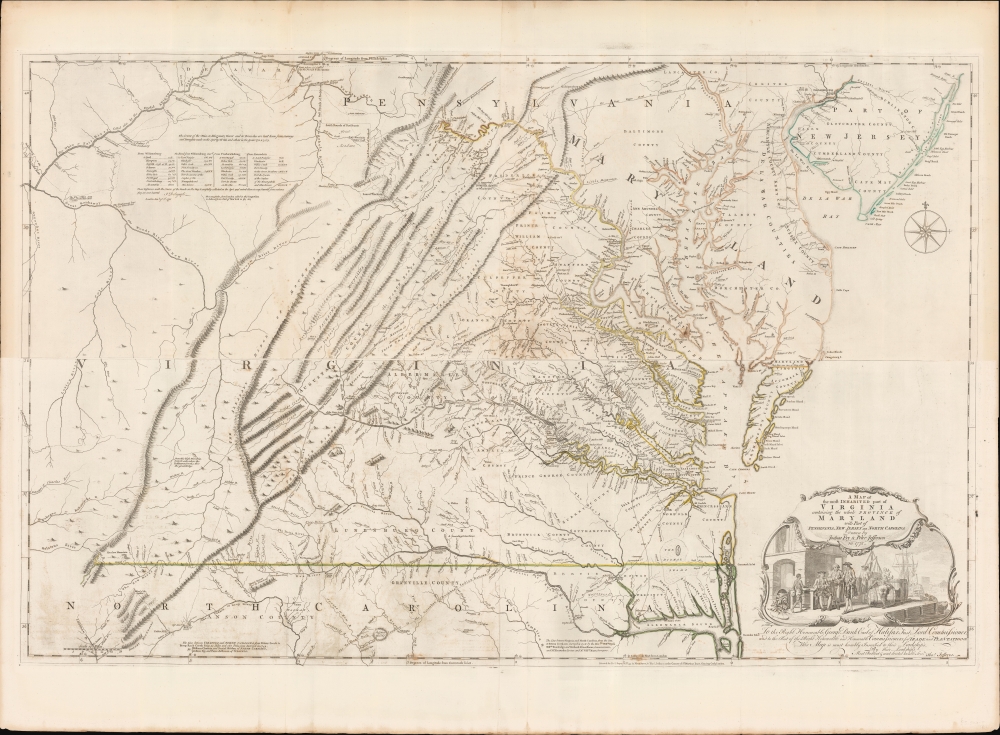

Title
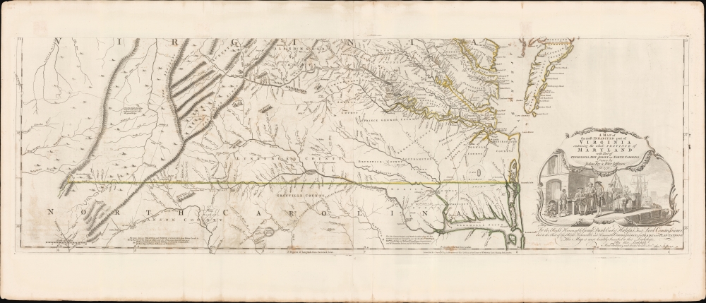
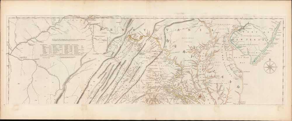
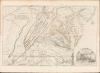
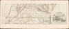
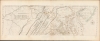
A Map of the most Inhabited part of Virginia containing the whole Province of Maryland with Part of Pensilvania, New Jersey and North Carolina drawn by Joshua Fry and Peter Jefferson in 1775.
1775 (dated) 30.75 x 48.25 in (78.105 x 122.555 cm) 1 : 650000
1775 (dated) 30.75 x 48.25 in (78.105 x 122.555 cm) 1 : 650000
Description
FOR THE ORIGINAL ANTIQUE MAP, WITH HISTORICAL ANALYSIS, CLICK HERE.
Digital Map Information
Geographicus maintains an archive of high-resolution rare map scans. We scan our maps at 300 DPI or higher, with newer images being 600 DPI, (either TIFF or JPEG, depending on when the scan was done) which is most cases in suitable for enlargement and printing.
Delivery
Once you purchase our digital scan service, you will receive a download link via email - usually within seconds. Digital orders are delivered as ZIP files, an industry standard file compression protocol that any computer should be able to unpack. Some of our files are very large, and can take some time to download. Most files are saved into your computer's 'Downloads' folder. All delivery is electronic. No physical product is shipped.
Credit and Scope of Use
You can use your digial image any way you want! Our digital images are unrestricted by copyright and can be used, modified, and published freely. The textual description that accompanies the original antique map is not included in the sale of digital images and remains protected by copyright. That said, we put significant care and effort into scanning and editing these maps, and we’d appreciate a credit when possible. Should you wish to credit us, please use the following credit line:
Courtesy of Geographicus Rare Antique Maps (http://www.geographicus.com).
How Large Can I Print?
In general, at 300 DPI, you should at least be able to double the size of the actual image, more so with our 600 DPI images. So, if the original was 10 x 12 inches, you can print at 20 x 24 inches, without quality loss. If your display requirements can accommodate some loss in image quality, you can make it even larger. That being said, no quality of scan will allow you to blow up at 10 x 12 inch map to wall size without significant quality loss. For more information, it is best consult a printer or reprographics specialist.
Refunds
If the high resolution image you ordered is unavailable, we will fully refund your purchase. Otherwise, digital images scans are a service, not a tangible product, and cannot be returned or refunded once the download link is used.
Cartographer S
Joshua Fry (1699–1754) was an English adventurer, professor, investor who became an official in the colony of Virginia. He is best known as a surveyor and cartographer who collaborated with Peter Jefferson, the father of future U.S. president Thomas Jefferson in producing the quintessential colonial map of Virginia and Maryland.
Fry was born in Somerset, England, and educated at Oxford. He sought his fortune in the colonies, emigrating to Virginia in 1726. There he would marry and raise a large family. He would become a professor of mathematics and natural philosophy. After marrying a young widow, he would give up his professorship to operate her plantation. At that time he would begin a public career as a judge but would also buy and sell real estate, and worked as well as a surveyor. In 1746 Fry and Peter Jefferson were commissioned to survey Lord Fairfax's lands in the Piedmont region of Virginia, and three years later the two were tasked with surveying the boundary with North Carolina. In 1750 they would be assigned to survey the border with Maryland as well. On the strength of these and other surveys, Fry and Jefferson would produce their 1751 masterpiece map, A Map of the most Inhabited part of Virginia containing the whole Province of Maryland. Fry had served as colonel in Albemarle County's militia, and at the beginning of the French and Indian War he was named Commander-in-Chief of colonial forces, given command of the Virginia Regiment, and ordered to capture Fort Duquesne from the French. On the way, he fell from his horse and died from the resultant injuries. He was succeeded in command of the Virginia Regiment by a young officer named George Washington.
More by this mapmaker...
Peter Jefferson (February 29, 1708 - August 17, 1757) was a planter, cartographer and politician best known as the father of US President Thomas Jefferson (1743–1826). In collaboration with surveyor Joshua Fry, he produced in 1751 the so-called 'Fry-Jefferson Map'. Jefferson was born in the Virginia Colony at Osbornes on the James River, the son of a large property owner. He received no formal education in his youth, but was a well-read autodidact. He inherited land, becoming a prosperous plantation owner, slave owner, sheriff, surveyor and justice of the peace. He was also a surveyor and mapmaker: in 1749 he collaborated with Joshua Fry in the production of their 1751 A Map of the most Inhabited part of Virginia containing the whole Province of Maryland, which accurately depicted the Allegheny Mountains for the first time and showed the route of what would later be known as the Great Wagon Road. Learn More...
Thomas Jefferys (1695 - November 20, 1771) was one of the most prominent and prolific map publishers and engravers of his day. Jefferys was born in Birmingham and was apprenticed to the engraver Emmanuel Bowen in 1735. Later, in the 1740s he engraved several maps for the popular periodical Gentleman's Magazine. Around 1740 Jefferys was finally able to go into business for himself and in 1746 received an appointment as 'Geographer to Fredrick, Prince of Wales,' which shortly after translated to the position of 'Royal Cartographer to King George III.' Jefferys initially specialized in compiling and re-engraving the works of earlier cartographers into more coherent cartographic wholes. Later, while not salaried position, Jefferys' appointment as 'Royal Cartographer' guaranteed preferential access to the most up to date cartographic material available, allowing him to produce new and updated charts of exceptional accuracy. He his best known for his maps of the Americas, particularly the posthumously published 1775 American Atlas, which included some of the finest and most important late colonial era maps of America ever made. Despite his prolific publishing history, royal appointments, and international publishing fame, Jefferys lived most of his life in dire economic straits. He was bailed out of bankruptcy by Robert Sayer during the production of the American Atlas. In the end, Jefferys died suddenly with very little to his name. Nonetheless, his cartographic legacy survived, and even after his death in 1771, many of his important maps continued to be published and republished by Sayer and Bennet, Conrad Lotter, Georges Louis Le Rouge, Laurie and Whittle, and others. Many attribute some of Jefferys best maps to the colorful and criminally inclined Irish cartographic genius Braddock Mead (John Green, c. 1688 - 1757), who is considered the 'secret behind Jefferys.' Jefferys was succeeded by his son, also Thomas, who had little success as a cartographer and eventually partnered with, then sold his stock and plates to William Faden - Jefferys' true heir. Learn More...
Christopher Gist (1706–1759) was an explorer, surveyor, and frontiersman in Colonial America. He was one of the first English explorers of the Ohio River valley, and provided the first detailed description of that country to colonists in the Thirteen Colonies. Little is known of his education as a surveyor, which was probably received from his father Richard Gist, who helped lay out the plan for the city of Baltimore. By 1750 Gist had settled in northern North Carolina near the Yadkin River; that year, he was hired by the Ohio Company to explore the Ohio Country as far as the present location of Louisville, Kentucky; he mapped Ohio betweeen the present day location of Pittsburgh to the Miami River. In 1753 he accompanied George Washington on his mission to convince the French to abandon Ohio; during their travels on this futile effort, Gist saved Washington's life twice - once from drowning in the frozen Allegheny River, and once from Indian attack.
In 1754 Gist accompanied Washington and the Virginia Regiment in their attempt to forcibly drive the French from Ohio, resulting in their defeat at the hands of the French at Fort Necessity. Gist was also part of the Braddock Expedition during its 1755 defeat by the French and their Native American allies. Gist died in 1759, either in Carolina or Georgia, of smallpox. Learn More...