This copy is copyright protected.
Copyright © 2025 Geographicus Rare Antique Maps
Digital Image: 1804 / 1904 Map of the Ouachita River, Arkansas, Louisiana
WashitaRiver-king-1904_d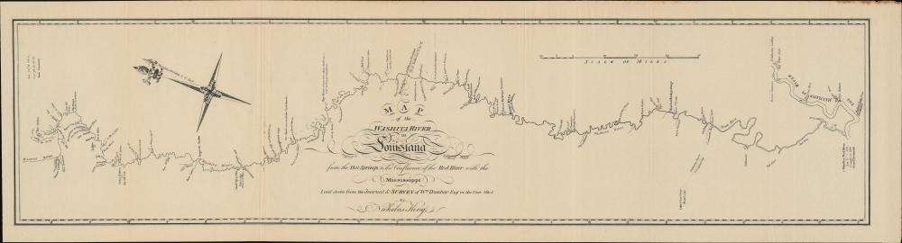

FOR THE ORIGINAL ANTIQUE MAP, WITH HISTORICAL ANALYSIS, CLICK HERE.
Digital Map Information
Geographicus maintains an archive of high-resolution rare map scans. We scan our maps at 300 DPI or higher, with newer images being 600 DPI, (either TIFF or JPEG, depending on when the scan was done) which is most cases in suitable for enlargement and printing.
Delivery
Once you purchase our digital scan service, you will receive a download link via email - usually within seconds. Digital orders are delivered as ZIP files, an industry standard file compression protocol that any computer should be able to unpack. Some of our files are very large, and can take some time to download. Most files are saved into your computer's 'Downloads' folder. All delivery is electronic. No physical product is shipped.
Credit and Scope of Use
You can use your digial image any way you want! Our digital images are unrestricted by copyright and can be used, modified, and published freely. The textual description that accompanies the original antique map is not included in the sale of digital images and remains protected by copyright. That said, we put significant care and effort into scanning and editing these maps, and we’d appreciate a credit when possible. Should you wish to credit us, please use the following credit line:
Courtesy of Geographicus Rare Antique Maps (http://www.geographicus.com).
How Large Can I Print?
In general, at 300 DPI, you should at least be able to double the size of the actual image, more so with our 600 DPI images. So, if the original was 10 x 12 inches, you can print at 20 x 24 inches, without quality loss. If your display requirements can accommodate some loss in image quality, you can make it even larger. That being said, no quality of scan will allow you to blow up at 10 x 12 inch map to wall size without significant quality loss. For more information, it is best consult a printer or reprographics specialist.
Refunds
If the high resolution image you ordered is unavailable, we will fully refund your purchase. Otherwise, digital images scans are a service, not a tangible product, and cannot be returned or refunded once the download link is used.
Nicholas King (1771 - 1812) was an English-born artist, surveyor, and cartographer who played an important role in the early years of the American Republic. Born in Yorkshire to a father who was also a land surveyor, he left for New York in 1793 and soon moved to Philadelphia to take up work as a draughtsman and surveyor. In 1796, he moved to what would become Washington, D.C., where he undertook cadastral surveys of the city (he was a proponent of the original 1791 L'Enfant Plan for Washington, D.C.). In 1801, King was tasked by Albert Gallatin, Secretary of the Treasury, to produce a map of the Northwest Territory. Two years later, Gallatin asked him to produce a 'blank map' of the continent indicating the Mississippi River and Pacific Coast, for use on the Lewis and Clark Expedition. While the expedition was underway, King was dispatched to its winter camp at Fort Mandan to produce a set of maps based on the sketches of William Clark. He likewise produced maps of the southern portion of the Louisiana Territory (portions of present-day Louisiana, Arkansas, and Texas) from sketches of William Dunbar and the Curtis-Freeman Expedition. King was something of a polymath and inventor, and dabbled in politics and manufacturing late in his life. More by this mapmaker...
William Dunbar (1749 - 1810) was a Scottish-born businessman, surveyor, scholar, and explorer who played an important role in mapping the southern portion of the Louisiana Territory following the Louisiana Purchase. Born to an aristocratic family in Moray, Scotland, Dunbar was quiet and studious from an early age. He attended King's College in Aberdeen and was especially interested in natural sciences. As he was the fourth of his father's sons, he had few prospects in terms of inheritance, and sailed to America in 1771, settling in Philadelphia, to try his hand as a merchant. He then migrated to British West Florida and was granted land near Fort New Richmond (Baton Rouge). In 1784, he and his business partner established a large plantation near Natchez, Mississippi, where slaves primarily grew indigo and cotton. He acquired other lands in the vicinity and made additional income conducting surveys for the Spanish in Florida proper. He served as the Surveyor-General of West Florida in 1798. In 1800, he was elected to the American Philosophical Society and in his later years especially published works on a variety of topics including meteorology, astronomy, natural history, Native American languages, and American Sign Language. Through these endeavors, he gained the admiration of Thomas Jefferson, who in 1804 assigned Dunbar to lead a 15-man expedition to explore the southern portion of the Louisiana Purchase. Due to frictions with the Spanish and Native Americans, the journey had to be curtailed in its ambitions, the expedition explored the Red and Ouachita Rivers, produced the earliest detailed maps of the region, and collected a great deal of scientific data. Two years later, Dunbar was instrumental in planning a follow-up Red River Expedition (known as the Freeman-Custis Expedition), but was unable to join it himself due to poor health. Learn More...
Copyright © 2025 Geographicus Rare Antique Maps | Geographicus Rare Antique Maps
This copy is copyright protected.
Copyright © 2025 Geographicus Rare Antique Maps