Digital Image: 1804 Joseph Ellicott Map of New York State West of the Geneseo
WesternNewYork-ellicott-1804_d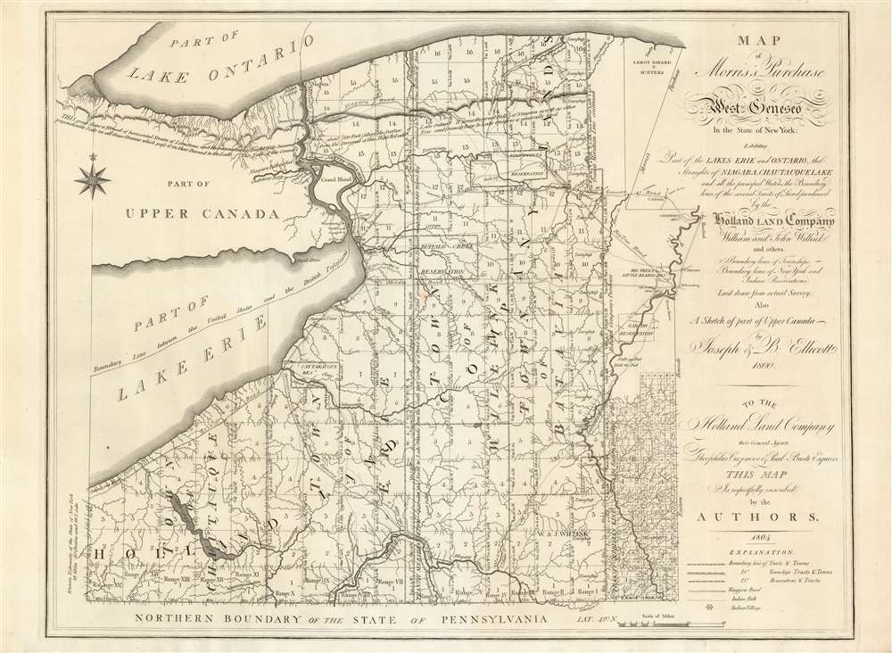

Title
Map of Morris's Purchase or West Geneseo In the State of New York.
1804 (dated) 20.3 x 26.25 in (51.562 x 66.675 cm) 1 : 336000
1804 (dated) 20.3 x 26.25 in (51.562 x 66.675 cm) 1 : 336000
Description
FOR THE ORIGINAL ANTIQUE MAP, WITH HISTORICAL ANALYSIS, CLICK HERE.
Digital Map Information
Geographicus maintains an archive of high-resolution rare map scans. We scan our maps at 300 DPI or higher, with newer images being 600 DPI, (either TIFF or JPEG, depending on when the scan was done) which is most cases in suitable for enlargement and printing.
Delivery
Once you purchase our digital scan service, you will receive a download link via email - usually within seconds. Digital orders are delivered as ZIP files, an industry standard file compression protocol that any computer should be able to unpack. Some of our files are very large, and can take some time to download. Most files are saved into your computer's 'Downloads' folder. All delivery is electronic. No physical product is shipped.
Credit and Scope of Use
You can use your digial image any way you want! Our digital images are unrestricted by copyright and can be used, modified, and published freely. The textual description that accompanies the original antique map is not included in the sale of digital images and remains protected by copyright. That said, we put significant care and effort into scanning and editing these maps, and we’d appreciate a credit when possible. Should you wish to credit us, please use the following credit line:
Courtesy of Geographicus Rare Antique Maps (http://www.geographicus.com).
How Large Can I Print?
In general, at 300 DPI, you should at least be able to double the size of the actual image, more so with our 600 DPI images. So, if the original was 10 x 12 inches, you can print at 20 x 24 inches, without quality loss. If your display requirements can accommodate some loss in image quality, you can make it even larger. That being said, no quality of scan will allow you to blow up at 10 x 12 inch map to wall size without significant quality loss. For more information, it is best consult a printer or reprographics specialist.
Refunds
If the high resolution image you ordered is unavailable, we will fully refund your purchase. Otherwise, digital images scans are a service, not a tangible product, and cannot be returned or refunded once the download link is used.
Cartographer
Joseph Ellicott (November 1, 1760 - August 19, 1826) was an American surveyor, city planner, land office agent, lawyer and politician. He is known for having produced the city plans of Batavia and Buffalo in New York State, and produced the first detailed map of New York State west of the Genesee River. He was born in Bucks County, Pennsylvania to Quaker parents, along with his older brother Andrew, (who surveyed the future grounds of Washington, D. C.) and his younger sibling Benjamin, who would become a U.S. Congressman. His education is not known, but he was his brother Andrew's chief assistant during the latter part of the Washington D.C. survey. He later traveled to Georgia to survey the newly established boundary with the Creek tribe. In 1797 he was hired by the Holland Land Company to survey the huge tract of western New York (later known as The Holland Purchase.) He spent the next two years living outdoors undertaking the survey, which he finally completed in October 1800. He would become the company's agent in Batavia, New York, whose city plan he executed in 1801. He did the same in 1804 for the village of Buffalo. He was an early advocate for the creation of the Erie Canal, and was among the Commissioners appointed in 1816 to supervise the canal construction. More by this mapmaker...
References
Rumsey 3712. OCLC 52510562. Streeter 892; Rumsey 3712; Nestler, H., A Bibliography of New York State Communities, Counties, Towns, Villagesp.109; Vail 1223; Dict. of Amer. Biog. vol. 6, pp. 90-91.