This copy is copyright protected.
Copyright © 2025 Geographicus Rare Antique Maps
Digital Image: 1852 Burr / Chandler Map of the World promoting Trade
World-burr-1853_d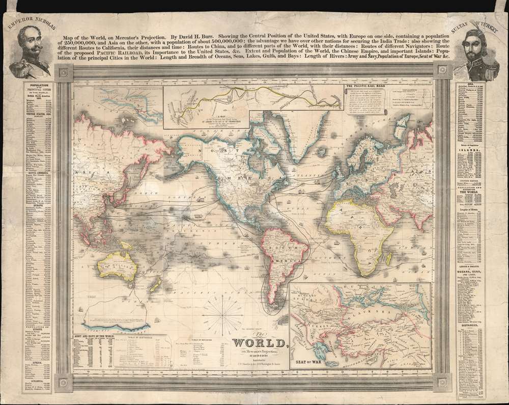

FOR THE ORIGINAL ANTIQUE MAP, WITH HISTORICAL ANALYSIS, CLICK HERE.
Digital Map Information
Geographicus maintains an archive of high-resolution rare map scans. We scan our maps at 300 DPI or higher, with newer images being 600 DPI, (either TIFF or JPEG, depending on when the scan was done) which is most cases in suitable for enlargement and printing.
Delivery
Once you purchase our digital scan service, you will receive a download link via email - usually within seconds. Digital orders are delivered as ZIP files, an industry standard file compression protocol that any computer should be able to unpack. Some of our files are very large, and can take some time to download. Most files are saved into your computer's 'Downloads' folder. All delivery is electronic. No physical product is shipped.
Credit and Scope of Use
You can use your digial image any way you want! Our digital images are unrestricted by copyright and can be used, modified, and published freely. The textual description that accompanies the original antique map is not included in the sale of digital images and remains protected by copyright. That said, we put significant care and effort into scanning and editing these maps, and we’d appreciate a credit when possible. Should you wish to credit us, please use the following credit line:
Courtesy of Geographicus Rare Antique Maps (http://www.geographicus.com).
How Large Can I Print?
In general, at 300 DPI, you should at least be able to double the size of the actual image, more so with our 600 DPI images. So, if the original was 10 x 12 inches, you can print at 20 x 24 inches, without quality loss. If your display requirements can accommodate some loss in image quality, you can make it even larger. That being said, no quality of scan will allow you to blow up at 10 x 12 inch map to wall size without significant quality loss. For more information, it is best consult a printer or reprographics specialist.
Refunds
If the high resolution image you ordered is unavailable, we will fully refund your purchase. Otherwise, digital images scans are a service, not a tangible product, and cannot be returned or refunded once the download link is used.
David Hugh Burr (August 18, 1803 - December 25, 1875) of one of the first and most important truly American cartographers and map publishers. Burr was born in Bridgeport Connecticut in August of 1803. In 1822 Burr moved to Kingsboro, New York to study law. A year and a half later he was admitted to the New York Bar association. Burr must have questioned his choice of careers because shortly after being admitted to the Bar, he joined the New York State Militia. Though largely untrained in the art of surveying, Burr was assigned to work under Surveyor General of New York, Simeon De Witt, to survey several New York Roadways. Seeing a window of opportunity, Burr was able to negotiate with the governor of New York at the time, De Witt Clinton, to obtain copies of other New York survey work in order to compile a map and Atlas of the state of New York. Recognizing the need for quality survey work of its territory, the government of New York heartily endorsed and financed Burr's efforts. The resulting 1829 Atlas of the State of New York was the second atlas of an individual U.S. state and one of the most important state atlases ever produced. Burr went on to issue other maps both of New York and of the United States in general. In cooperation with publishing firm of Illman & Pillbrow, he produced an important New Universal Atlas and, with J.H. Colton, several very important maps of New York City. In recognition of this work, Burr was appointed both "Topographer to the Post office" and "Geographer to the House of Representatives of the United States". Later, in 1855, Burr was assigned to the newly created position of Surveyor General to the State of Utah. Burr retired from the position and from cartographic work in general in 1857 when light of some of his financial misdeeds and frauds came to light. He was accused of submitting false expense reports and underpaying employees, among other indiscretions. More by this mapmaker...
Samuel Ward Chandler (July 12, 1803 - April 9, 1900) was a Boston-based engraver and lithographer active in the middle part of the 19th century. He was born in Petersham, Massachusetts, and attended Leicester Academy, then studied Law Harvard, graduating in 1822. He worked in the Law Office of Tehophilus Parsons (Chandler?) for one year, before leaving the law in favor of business. He founded the lithographing and engraving firm of S. W. Chandler and Bros. with his brother John Greene (1815 - 1879) around 1844. The firm was most active from 1844 to 1858, with most of their publications dating from 1855 - 1857. Chandler printed views, decorative prints, and maps. Around 1870 he opened a paper manufactory in Boston, which he promptly relocated to Delaware. He remained in business until 1876, before formally retiring. Chandler lived in most of his early life Roxbury, where his family was based since 1637, but at some point after 1870, relocated to 1511 Girard Avenue, Philadelphia, where he died of the 'grip'. In his later year he was hailed as Harvard's oldest living alum. Learn More...
Samuel Stiles (July 15, 1796 - April 3, 1861) was a New York based engraver of maps and bank notes active in the middle part of the 19th century. Stiles was born in East Windsor, Connecticut, and there served his apprenticeship as a line-engraver under self-taught master Abner Reed. In 1821, following his apprenticeship, Stiles relocated to Hartford, Connecticut, with is former master, Abner Reed, to form the firm of Reed and Stiles. Reed and Stiles worked in portrait, historical, landscape, and map engraving on wood and copper. Another former Reed apprentice, Pelton, joined the firm in 1822, changing the name of the firm to Reed, Stiles, and Pelton. Around this time, he also joined the Connecticut State Militia where he was commissioned as a corporal in the same Calvary regiment as his brother Asabel Chapin Stiles. In 1824, he relocated to Utica, New York, where worked with Vistus Balch, also a former Reed apprentice. Stiles and Balch moved to New York together in 1828 to found Balch and Stiles, banknote engravers. In 1833, Samuel Stiles partnered with Joseph Hutchins Colton, then a young man, to found Stiles and Company – Colton being the 'company.' This partnership lasted until 1836 when he and Colton published their great plan of New York City, known as the 'Colton Map.' Colton went his own way and became a major American map publisher. Stiles moved a few blocks away and partnered with George E. Sherman and Colin Smith to found Stiles, Sherman and Smith. The partnership dissolved in 1840 and Stiles took up again with J. H. Colton, who was already becoming prominent. In 1841, he joined the firm of Danforth, Ball, and Company, Bank Note Engravers. This firm eventually merged into the American Bank Note Company. In 1859 Stiles became a founding member of the National Banknote Company, which incorporated as the American Banknote Company. He was the treasurer of this successful firm until his death in 1861. On a side note, Stiles married the daughter of Abner Reed, Charlotte Sophia Reed, in 1825. Their son, Henry Reed Stiles attained fame of his own as historian and genealogist. Learn More...
Copyright © 2025 Geographicus Rare Antique Maps | Geographicus Rare Antique Maps
This copy is copyright protected.
Copyright © 2025 Geographicus Rare Antique Maps