This copy is copyright protected.
Copyright © 2025 Geographicus Rare Antique Maps
Digital Image: 1593 Cornelis De Jode Double Hemisphere Polar Projection World
World-jode-1593_d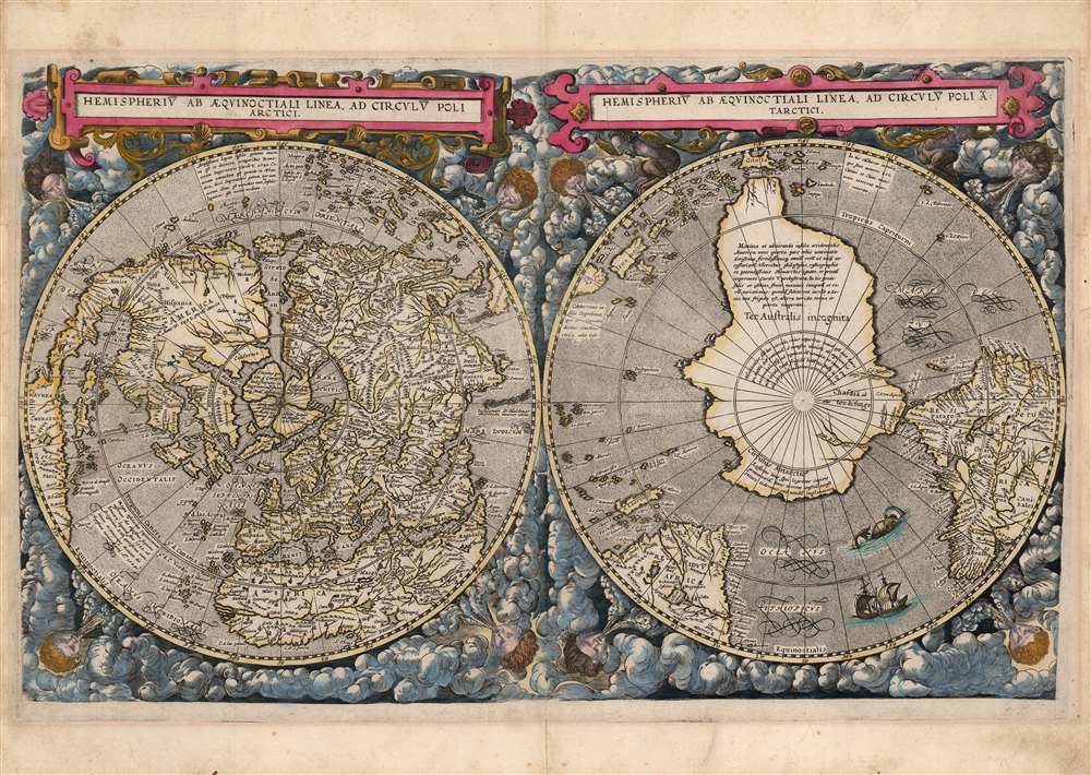

FOR THE ORIGINAL ANTIQUE MAP, WITH HISTORICAL ANALYSIS, CLICK HERE.
Digital Map Information
Geographicus maintains an archive of high-resolution rare map scans. We scan our maps at 300 DPI or higher, with newer images being 600 DPI, (either TIFF or JPEG, depending on when the scan was done) which is most cases in suitable for enlargement and printing.
Delivery
Once you purchase our digital scan service, you will receive a download link via email - usually within seconds. Digital orders are delivered as ZIP files, an industry standard file compression protocol that any computer should be able to unpack. Some of our files are very large, and can take some time to download. Most files are saved into your computer's 'Downloads' folder. All delivery is electronic. No physical product is shipped.
Credit and Scope of Use
You can use your digial image any way you want! Our digital images are unrestricted by copyright and can be used, modified, and published freely. The textual description that accompanies the original antique map is not included in the sale of digital images and remains protected by copyright. That said, we put significant care and effort into scanning and editing these maps, and we’d appreciate a credit when possible. Should you wish to credit us, please use the following credit line:
Courtesy of Geographicus Rare Antique Maps (http://www.geographicus.com).
How Large Can I Print?
In general, at 300 DPI, you should at least be able to double the size of the actual image, more so with our 600 DPI images. So, if the original was 10 x 12 inches, you can print at 20 x 24 inches, without quality loss. If your display requirements can accommodate some loss in image quality, you can make it even larger. That being said, no quality of scan will allow you to blow up at 10 x 12 inch map to wall size without significant quality loss. For more information, it is best consult a printer or reprographics specialist.
Refunds
If the high resolution image you ordered is unavailable, we will fully refund your purchase. Otherwise, digital images scans are a service, not a tangible product, and cannot be returned or refunded once the download link is used.
Cornelis de Jode (1568 – October 17, 1600) was an Antwerp cartographer, engraver and publisher, He was the son and heir of Gerard de Jode, also a cartographer and publisher. Cornelis studied science at Academy of Douai, but it can be understood that his main education in the trade was at the hands of his father. On his father's death in 1591, Cornelis de Jode took over the work on his father's atlas, Speculum Orbis Terrarum. This had enjoyed publication in a single edition of 1578, overshadowed by the competition posed by Abraham Ortelius' (1527 - 1598) Theatrum Orbis Terrrum. Cornelis published a second edition, to which he added many updated maps to bring the work up to date with its competition. Despite the improvements brought to the atlas, both aesthetic and geographic, De Jode was unable to break Ortelius' grip on the market and there were no further editions of the atlas. After his death, the engraving plates were sold to Ortelius' executor Johannes Baptista Vrients (1552 - 1612), who was continuing to publish the Theatrum. Vrients would utilize several decorative plates from the Speculum, but the complete work and its maps were not published again - likely they were destroyed by Vrients to keep them from competing with his editions of the i>Theatrum. More by this mapmaker...
Gerard De Jode (1516/17 - February 5, 1591) was a Dutch publisher, engraver and cartographer active in Antwerp in the mid-to-late 16th century. De Jode was born in Nijmegen. Following a period as an apprentice and journeyman, (about which nothing comes down to us), he was admitted as a free master to Antwerp's artists' Guild of Saint Luke in 1547. He received the right to publish in that city in 1551. Henceforth he worked as a publisher and printseller in that city - although records also refer to him as a bookseller, art seller, map painter, engraver, and plate printer. He became one of Antwerp's most successful and prolific printers: he built up a large and varied stock of more than 1,200 prints and maps, and in addition to his own children maintained a shop and was taking on apprentices as early as 1549. De Jode's shop was home to many of Antwerp's best engravers, including the famous Van Doetecum brothers.
His publication in 1579 of the Thesaurus sacrarumhistoriarum veteris testamenti set the standard for over a century of Biblical illustration. His cartographic work began with the printing of other mapmakers' work (for example Gastaldi's map of the world in 1555, Jacob van Deventer's map of Brabant in 1558, and Ortelius' eight sheet map of the world in 1564.) He is best known for his 1578 atlas Speculum Orbis Terrarum. Despite the excellence of this work, it performed poorly due to the overwhelming competition posed by Abraham Ortelius' Theatrum Orbis Terrarum, which had already been eight years in publication. Between the Theatrum's popularity (and Ortelius' superior political connections, employed successfully in a vigorous defense of his license and monopoly on the work) De Jode's atlas was never a strong seller. Gerard printed only one edition of the work, compared to something on the order of 40 for the Ortelius atlas. Gerard de Jode planned an enlarged edition, but died before it could be finished. His son Cornelis de Jode completed the labor, publishing the Speculum Orbis Terrae in 1593. This edition, too, of the Speculum failed to compete with Ortelius' powerhouse. On top of that, much of the De Jodes' stock was actively purchased and destroyed by Ortelius and his executors in order to remove it from the market. Thus, oneresult of De Jode's ill-starred competition with Ortelius is that while most of Ortelius' maps are relatively ubiquitous on the market, all of De Jode's maps are rare, and sought after by the discerning collector. Learn More...
Guillaume Postel (March 25, 1510 – September 6, 1581) was a French linguist, astronomer, Christian Kabbalist, diplomat, polyglot, professor, religious universalist, and writer. He was born in Normandy, educated in Paris, and during his time there met Ignatius of Loyola and many of the founders of the Society of Jesus, retaining a lifelong affiliation with them (although he did not take vows with the order.) He was an adept linguist, focusing primarily on Semitic languages as well as Greek and Latin; this facility brought him to the attention of the French court, who would tap him for diplomatic duties. He attended the 1536 embassy of Jean de La Forêt to the Ottoman sultan Suleiman the Magnificent as a translator; Postel also acquired Ottoman manuscripts for the royal library, which remain in the Bibliothèque Nationale. Postel's works range from anaylses of Hebrew characters on Roman era coins to critiques of Protestantism, descriptions of Turkish society, studies of universal traits in world religions, and arguments for the unification of all Christian sects. His interests also impinged on cartography, partly stemming from his collection of manuscripts from the Holy Land and Syria. He published a geographical work in 1557 De Universitate Liber and appears to have drawn a polar projection map, although this was not published. He expanded on his work in Cosmographicae Disciplinae Compendium. Neither of these works contained any but the smallest and most diagrammatic maps, but in Cosmographicae, Postel clearly set out his geographical ideas, including the naming of an Australian continent - Chasdia - distinctly separate from both Asia and Africa. Cosmographicae included an index of place names which would inform his 1581 world map, Polo aptata Nova Charta Universi. This map is unacquirable - it survives in only a single confirmed example - would influence several sixteenth century mapmakers, none so apparently as Cornelis de Jode in his 1593 polar projection world map.
Postel would also travel extensively in Central Europe and Italy, all the while building his manuscript collection, and translating many works. His ideas on universalism would combine with a conviction that he was experiencing prophetic visions, and that he was destined to become a unifier of all the world's religions. His publication of these ideas would put him before the Inquisition. Allies amongst his prosecutors were able to find him guilty of insanity, winning him imprisonment in preference of the execution a finding of heresy would result in. He would eventually be freed, but the 1566 exorcisms of Nicole Aubrey in Laon affected him to such a degree that he felt compelled to publish an account of it. In it, he repeated his insistence upon the interrelatedness of all parts of the universe and his own role in the unification of the world's faiths. As a result, he was returned to house arrest and spent the rest of his life confined to a monastery. Learn More...
Copyright © 2025 Geographicus Rare Antique Maps | Geographicus Rare Antique Maps
This copy is copyright protected.
Copyright © 2025 Geographicus Rare Antique Maps