Digital Image: 1658 Nicolas Visscher Double Hemisphere Map of the World
World-visscher-1658_d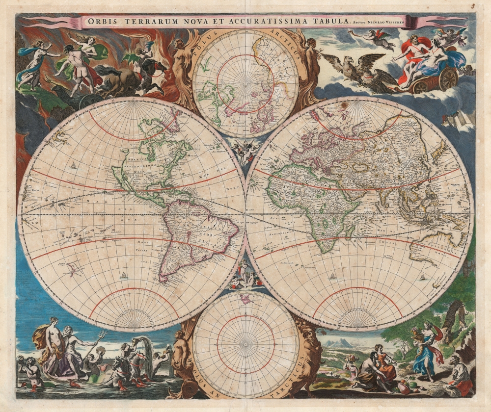


Title
Orbis Terrarum Nova et Accuratissima Tabula. Auctore Nicolao Visscher.
1658 (undated) 18.25 x 22 in (46.355 x 55.88 cm) 1 : 90000000
1658 (undated) 18.25 x 22 in (46.355 x 55.88 cm) 1 : 90000000
Description
FOR THE ORIGINAL ANTIQUE MAP, WITH HISTORICAL ANALYSIS, CLICK HERE.
Digital Map Information
Geographicus maintains an archive of high-resolution rare map scans. We scan our maps at 300 DPI or higher, with newer images being 600 DPI, (either TIFF or JPEG, depending on when the scan was done) which is most cases in suitable for enlargement and printing.
Delivery
Once you purchase our digital scan service, you will receive a download link via email - usually within seconds. Digital orders are delivered as ZIP files, an industry standard file compression protocol that any computer should be able to unpack. Some of our files are very large, and can take some time to download. Most files are saved into your computer's 'Downloads' folder. All delivery is electronic. No physical product is shipped.
Credit and Scope of Use
You can use your digial image any way you want! Our digital images are unrestricted by copyright and can be used, modified, and published freely. The textual description that accompanies the original antique map is not included in the sale of digital images and remains protected by copyright. That said, we put significant care and effort into scanning and editing these maps, and we’d appreciate a credit when possible. Should you wish to credit us, please use the following credit line:
Courtesy of Geographicus Rare Antique Maps (https://www.geographicus.com).
How Large Can I Print?
In general, at 300 DPI, you should at least be able to double the size of the actual image, more so with our 600 DPI images. So, if the original was 10 x 12 inches, you can print at 20 x 24 inches, without quality loss. If your display requirements can accommodate some loss in image quality, you can make it even larger. That being said, no quality of scan will allow you to blow up at 10 x 12 inch map to wall size without significant quality loss. For more information, it is best consult a printer or reprographics specialist.
Refunds
If the high resolution image you ordered is unavailable, we will fully refund your purchase. Otherwise, digital images scans are a service, not a tangible product, and cannot be returned or refunded once the download link is used.
Cartographer S
Nicholas Visscher I (1618 - 1679) was a Dutch engraver, cartographer and publisher. The son of Claes Jansz Visscher (1587 - 1652), he was brought up in and carried on the family publishing firm after his father's death. During his tenurem, the firm produced an array of maps that introduced a new level of artistic flourish to the Dutch mapmaking trade: the 'Jansson-Visscher' map of the New Netherlands and New Engand provided the model map for that region for over a century, and his 1658 world map was hailed by Shirley as the 'master forerunner of a number of highly decorative Dutch world maps produced throughout the remainder of the century.' He received a privilege from Holland and West Friesland in 1677; after his death the firm was taken up by his son, Nicholas II (1649 - 1702). Upon the death of Nicholas Visscher II, the business was carried on by the widowed Elizabeth Verseyl Visscher (16?? - 1726). After her death, the firm and all of its plates was liquidated to Peter Schenk. More by this mapmaker...
Nicolaes Pieterszoon Berchem (October 1, 1620 – February 18, 1683) was a respected and prolific Dutch Golden Age painter, particularly noted for his pastoral landscapes, allegories and genre pieces. His works were often populated with mythological figures. In the late 1650s he worked for Nicolas Visscher I, designing the latter's atlas and engraving (at least) the world map of that atlas. His work exemplified the Dutch Italianate landscape style of painting, employing classical ruins and pastoral imagery based on visits, or imagined visits to the Italian countryside. He was born in Haarlem, and was educated both by his father and an array of painters including van Goyen, de Grebber, Weenix, Wils and Moeyaert. He appears to have been an avid collector of prints as well: After marrying the daughter of his teacher Jan Wils, she kept him on a small allowance - but in order to support his collecting habit, he borrowed money from students and colleagues, later paying them back from the proceeds of paintings executed with his wife's knowledge. He was apparently a popular teacher with many painters having come up under his tutelage. We are not aware of how popular he may have been with his wife. Learn More...
Joan (Johannes) Blaeu (September 23, 1596 - December 21, 1673) was a Dutch cartographer active in the 17th century. Joan was the son of Willem Janszoon Blaeu, founder of the Blaeu firm. Like his father Willem, Johannes was born in Alkmaar, North Holland. He studied Law, attaining a doctorate, before moving to Amsterdam to join the family mapmaking business. In 1633, Willem arranged for Johannes to take over Hessel Gerritsz's position as the official chartmaker of the Dutch East India Company, although little is known of his work for that organization, which was by contract and oath secretive. What is known is his work supplying the fabulously wealthy VOC with charts was exceedingly profitable. Where other cartographers often fell into financial ruin, the Blaeu firm thrived. It was most likely those profits that allowed the firm to publish the Theatrum Orbis Terrarum, sive, Atlas Novus, their most significant and best-known publication. When Willem Blaeu died in 1638, Johannes, along with his brother Cornelius Blaeu (1616 - 1648) took over the management of the Blaeu firm. In 1662, Joan and Cornelius produced a vastly expanded and updated work, the Atlas Maior, whose handful of editions ranged from 9 to an astonishing 12 volumes. Under the brothers' capable management, the firm continued to prosper until the 1672 Great Amsterdam Fire destroyed their offices and most of their printing plates. Johannes Blaeu, witnessing the destruction of his life's work, died in despondence the following year. He is buried in the Dutch Reformist cemetery of Westerkerk. Johannes Blaeu was survived by his son, also Johannes but commonly called Joan II, who inherited the family's VOC contract, for whom he compiled maps until 1712. Learn More...
References
OCLC 23615754.