This copy is copyright protected.
Copyright © 2025 Geographicus Rare Antique Maps
Digital Image: 1887 Fowler Bird's-Eye View of Lititz, Lancaster, Pennsylvania
Lititz-fowler-1887_d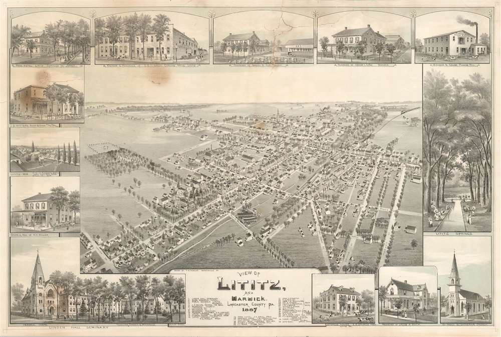

FOR THE ORIGINAL ANTIQUE MAP, WITH HISTORICAL ANALYSIS, CLICK HERE.
Digital Map Information
Geographicus maintains an archive of high-resolution rare map scans. We scan our maps at 300 DPI or higher, with newer images being 600 DPI, (either TIFF or JPEG, depending on when the scan was done) which is most cases in suitable for enlargement and printing.
Delivery
Once you purchase our digital scan service, you will receive a download link via email - usually within seconds. Digital orders are delivered as ZIP files, an industry standard file compression protocol that any computer should be able to unpack. Some of our files are very large, and can take some time to download. Most files are saved into your computer's 'Downloads' folder. All delivery is electronic. No physical product is shipped.
Credit and Scope of Use
You can use your digial image any way you want! Our digital images are unrestricted by copyright and can be used, modified, and published freely. The textual description that accompanies the original antique map is not included in the sale of digital images and remains protected by copyright. That said, we put significant care and effort into scanning and editing these maps, and we’d appreciate a credit when possible. Should you wish to credit us, please use the following credit line:
Courtesy of Geographicus Rare Antique Maps (http://www.geographicus.com).
How Large Can I Print?
In general, at 300 DPI, you should at least be able to double the size of the actual image, more so with our 600 DPI images. So, if the original was 10 x 12 inches, you can print at 20 x 24 inches, without quality loss. If your display requirements can accommodate some loss in image quality, you can make it even larger. That being said, no quality of scan will allow you to blow up at 10 x 12 inch map to wall size without significant quality loss. For more information, it is best consult a printer or reprographics specialist.
Refunds
If the high resolution image you ordered is unavailable, we will fully refund your purchase. Otherwise, digital images scans are a service, not a tangible product, and cannot be returned or refunded once the download link is used.
Thaddeus Mortimer Fowler (1842 - March 17, 1922) was an American cartographer and the most prolific of all American city viewmakers. Born in Lowell, Massachusetts, Fowler enlisted in the Union Army in 1861. He was wounded at the Second Battle of Bull Run and was discharged in February 1863. After his discharge, Fowler made a living by visiting army camps and making tintypes of soldiers. He moved to Madison, Wisconsin, in 1864, to work in his uncle John Mortimer Fowler's photography studio. Fowler likely met Albert Ruger, the famous viewmaker, when he visited Madison in 1867 to work on a view he produced later that year. Ruger had recently lost his last assistant, Eli. S. Glover, who had opened his own publishing firm in Chicago. Ruger probably offered Fowler a job as his sales and subscription agent during this trip, but it is possible that the association between the two men started earlier. Fowler worked for Ruger for two years, as his canvassing and subscription agent in Iowa, Nebraska, and other Midwestern states. It is also likely that Fowler helped Ruger increase his output, since Ruger published around forty views in 1868 and over sixty in 1869. Fowler struck out on his own in 1870 and published two views of towns in Wisconsin: Oconomowoc and Omro. Fowler drew the Oconomowoc view, but Howard Heston (H. H.) Bailey signed the Omro view. Fowler and Bailey would have a professional relationship until Bailey's death in 1878. Bailey's brother Oakley Hoopes (O. H.) Bailey, joined them in 1872. Between 1872 and 1875, the combination of three three names appears almost interchangeably, although Fowler and the Baileys parted ways in 1874. Fowler's name is the only one that appears on lithographs published in 1876. Fowler and O. H. Bailey resumed their professional partnership in 1879 and published several views together, although not all the works are attributed to both men. Between 1887 and 1906, Fowler concentrated on views of Pennsylvania, and produced over 200 lithographs of towns around the state, and his total output during these twenty years exceeded 280 prints. Over the course of his career, Fowler published over 420 prints, of which 248 were of Pennsylvania. Fowler suffered a Fallon an icy street in Middletown, New York, on March 1922 and died a week later on March 17. In his book Views and Viewmakers of Urban America John W. Reps proposes that Fowler was in Middletown promoting the updated view of that town he had recently published. More by this mapmaker...
Copyright © 2025 Geographicus Rare Antique Maps | Geographicus Rare Antique Maps
This copy is copyright protected.
Copyright © 2025 Geographicus Rare Antique Maps