This item has been sold, but you can get on the Waitlist to be notified if another example becomes available, or purchase a digital scan.
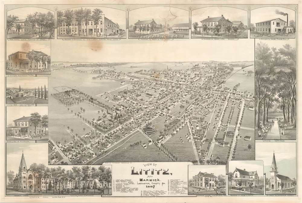
1887 Fowler Bird's-Eye View of Lititz, Lancaster, Pennsylvania
Lititz-fowler-1887
Title
1887 (dated) 22 x 33 in (55.88 x 83.82 cm)
Description
Lititz, Pennsylvania
Lititz, a town of nearly 10,000 people, was founded in 1756 by members of the Moravian Church and named after a castle in Bohemia near the village of Kunvald. For over a century, only Moravians could live in Lititz, and until 1855, only members of the Moravian Church could own houses; anyone else was required to lease. Today, Lititz is renowned in Pennsylvania for its annual Fourth of July celebration, along with its annual art show, antique fair, and the Chocolate Walk. Lititz was the winner of Budget Travel's 'America's Coolest Small Towns' in 2013.Chromolithography
Chromolithography is a color lithographic technique developed in the mid-19th century. The process involved using multiple lithographic stones, one for each color, to yield a rich composite effect. Oftentimes, the process would start with a black basecoat upon which subsequent colors were layered. Some chromolithographs used 30 or more separate lithographic stones to achieve the desired effect. Chromolithograph color could also be effectively blended for even more dramatic results. The process became extremely popular in the late 19th and early 20th centuries, when it emerged as the dominate method of color printing. The vivid color chromolithography produced made it exceptionally effective for advertising and propaganda imagery.Publication History and Census
This view was created and published by Thaddeus Mortimer Fowler in 1877. An example is part of the collection at the Library of Congress. A facsimile edition was published in 1980 by Lancaster Echoes.Cartographer
Thaddeus Mortimer Fowler (1842 - March 17, 1922) was an American cartographer and the most prolific of all American city viewmakers. Born in Lowell, Massachusetts, Fowler enlisted in the Union Army in 1861. He was wounded at the Second Battle of Bull Run and was discharged in February 1863. After his discharge, Fowler made a living by visiting army camps and making tintypes of soldiers. He moved to Madison, Wisconsin, in 1864, to work in his uncle John Mortimer Fowler's photography studio. Fowler likely met Albert Ruger, the famous viewmaker, when he visited Madison in 1867 to work on a view he produced later that year. Ruger had recently lost his last assistant, Eli. S. Glover, who had opened his own publishing firm in Chicago. Ruger probably offered Fowler a job as his sales and subscription agent during this trip, but it is possible that the association between the two men started earlier. Fowler worked for Ruger for two years, as his canvassing and subscription agent in Iowa, Nebraska, and other Midwestern states. It is also likely that Fowler helped Ruger increase his output, since Ruger published around forty views in 1868 and over sixty in 1869. Fowler struck out on his own in 1870 and published two views of towns in Wisconsin: Oconomowoc and Omro. Fowler drew the Oconomowoc view, but Howard Heston (H. H.) Bailey signed the Omro view. Fowler and Bailey would have a professional relationship until Bailey's death in 1878. Bailey's brother Oakley Hoopes (O. H.) Bailey, joined them in 1872. Between 1872 and 1875, the combination of three three names appears almost interchangeably, although Fowler and the Baileys parted ways in 1874. Fowler's name is the only one that appears on lithographs published in 1876. Fowler and O. H. Bailey resumed their professional partnership in 1879 and published several views together, although not all the works are attributed to both men. Between 1887 and 1906, Fowler concentrated on views of Pennsylvania, and produced over 200 lithographs of towns around the state, and his total output during these twenty years exceeded 280 prints. Over the course of his career, Fowler published over 420 prints, of which 248 were of Pennsylvania. Fowler suffered a Fallon an icy street in Middletown, New York, on March 1922 and died a week later on March 17. In his book Views and Viewmakers of Urban America John W. Reps proposes that Fowler was in Middletown promoting the updated view of that town he had recently published. More by this mapmaker...

