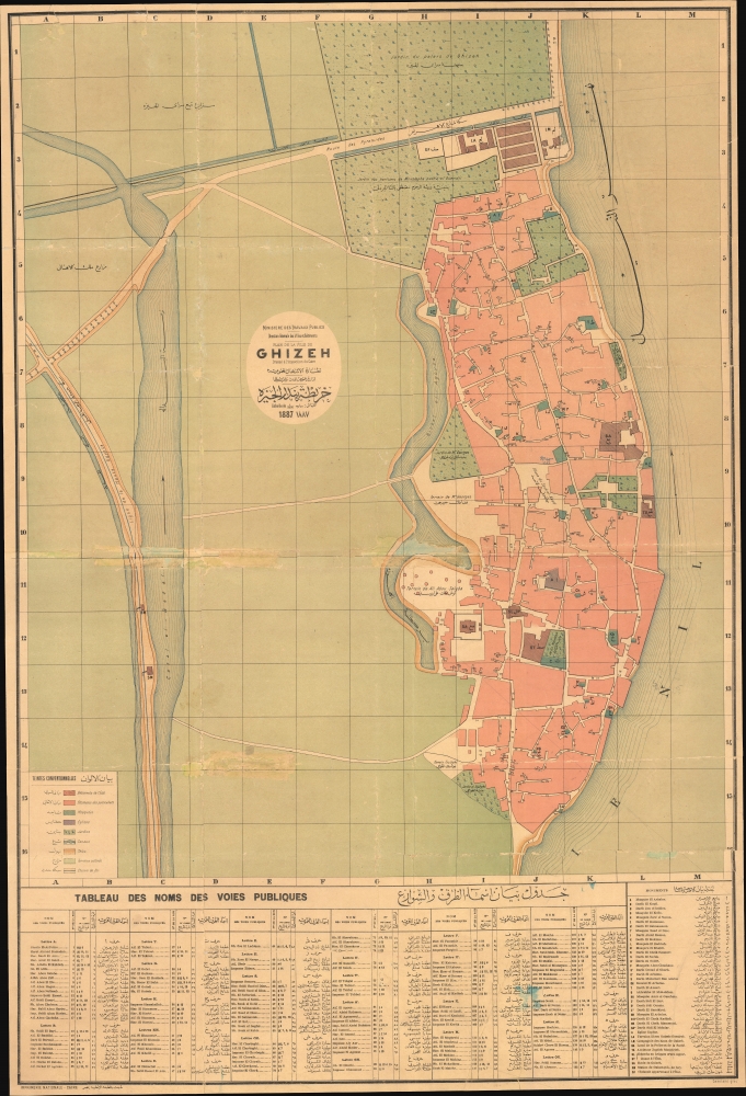
A scarce large-format bilingual (French - Arabic) city map of plan of Giza, Egypt, prepared by the Egyptian Supervision (Ministry) of Public Works and printed in 1887 by the National Printing Press of Egypt. It was produced as Giza was becoming an increasingly popular destination for European Egyptologists, a process facilitated by the completion of the railway seen here.
A Closer Look
Presenting the entirety of contemporary Giza, in the northern part of the modern city, this map provides granular detail on streets, landmarks, parks, gardens, government offices, and other features. The Nile River stands out prominently at right, while a series of canals can be seen inland. A grid surrounding the map corresponds to a bilingual index of streets at bottom, and streets are also numbered rather than named on the map itself. At bottom-right, a similar index of 'monuments' (mosques, churches, industrial works, shrines, schools, and the like) appears. Many of these sites still exist, such as the Souk al-Ahad Square (Place du Souk el-Ahad) and the Arbaeen Mosque (مسجد الأربعين, letter A here). A legend at bottom-left provides similar information, explaining the system of color shading indicating land use. Ancient Meets Modern
At left is a rail line ('Ligne de la Haute Egypte'), which intersects a road named 'Route des Pyramides,' and train station (labelled with 'SM'). These bits of modern infrastructure, along with other innovations such a waterworks and some state-owned industrial works, reflect the 19th century modernization efforts of the khedivate founded by Mohammed Ali Pasha (who was especially eager to work with French engineers). But the road and railway (completed in 1873) were European-guided efforts motivated primarily by one reason: to gain access to archaeological sites, including the iconic pyramids outside Giza.
This map is especially interesting in that the remnant French influence on Egyptian modernization efforts is clear, even though the British had occupied Egypt in 1882 and taken control of government ministries, including Public Works. In any event, the European rush to explore the archeological ruins near Giza was not accompanied by any standards or oversight, resulting in a rather chaotic situation. The celebrated French Egyptologist Gaston Maspero (1846 - 1914) aimed to rectify this situation during his tenure as Director of the Egyptian Antiquities Service, where he instituted a permit system to control, though not halt, excavations and removals from archaeological sites, while also charging tourists a fee to visit sites, which was then used to maintain them (the year before this map's publication, Maspero undertook an important survey of the Great Sphinx of Giza, excavating some 20 meters of sand). Publication History and Census
This map was prepared by the General Directorate of Cities and Buildings of the Egyptian Supervision of Public Works (Ministère des travaux publics Direction generale des villes et bâtiments / نِظَارَة الأشغال العمومية ادار عمومن المدن والمبالخام خر) and the Cairo Inspectorate (l'Inspection du Caire), likely a subordinate office of the former. It was engraved by one Damilano, about whom no information is available, and printed by the National Printing Press (Imprimerie Nationale / المطبعه الأهليه بمصر) in Cairo in 1887. The map is quite rare, only appearing in the institutional holdings of the British Library and Cornell University in the OCLC.
CartographerS
Egyptian Supervision of Public Works (1857 - 1914) (نِظَارَة الأشغال العمومية) was a government body under the khedivate government of Muhammed Ali and his successors. It grew out of an earlier office established in 1836, and after its name was changed in 1914 to the Ministry of Public Works (وزارة الأشغال العمومية) it continued to undertake the same mission of infrastructure maintenance and modernization, especially the canal system around the Nile. It is the basis for today's Ministry of Water Sources and Irrigation (وزارة الموارد المائية والري). For most of the 19th century, the office was strongly influenced by French engineering and cartography, including Xavier Pascal Coste (1787 - 1879), who was tasked by Muhammed Ali for undertaking several large-scale irrigation works. Following the British occupation of 1882, British engineers took over the department and launched even more ambitious projects, including the Aswan Low Dam, the largest dam of its kind in the world when completed. More by this mapmaker...
National Printing Press of Egypt (1820 - present) (المطبعه الأهليه) also known as the Amiri Press or Bulaq Press was the first modern printer in Egypt, and as a result has had a powerful influence on print culture in the modern history of Egypt and the wider Arabic-speaking world. Soon after taking power in Egypt, Muhammed Ali Pasha sent a mission to Milan to understand the latest European print methods. After several years of study and preparation, this effort resulted in the opening of a government-run printers in the Bulaq neighborhood of Cairo, soon afterwards changing its name to National Printing Press. It initially published works relating to military affairs and administration, but later expanded to include literary and scientific works in both Arabic and Ottoman Turkish. Among its publications were the Journal of the Khedive (Jurnal al-Khidiw / جرنال الخديوي), the first printed periodical in Arabic. It continued to publish groundbreaking works over the following decades, including in 1924 the King Fu'ād Quran, the first printed edition of the Quran approved by an Islamic authority (the al-Azhar Mosque in Cairo). Learn More...
Average. Wear and reinstatement here and there - evident in photo. Stabilized on archival tissue.
OCLC 557554312, 243637751.