Digital Image: 1887 Egyptian Supervision of Public Work French-Arabic City Map or Plan of Giza
Ghizeh-alashghalaleumumia-1887_d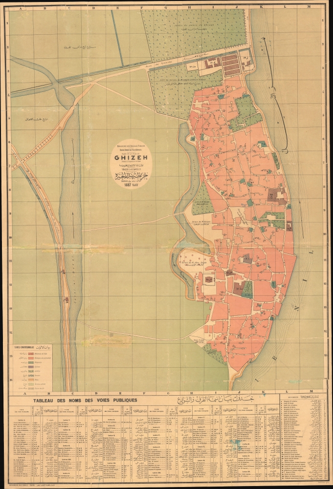


Title
Plan de la ville de Ghizeh / خريطة مدينة الجيزة.
1887 (dated) 39 x 26.25 in (99.06 x 66.675 cm) 1 : 2000
1887 (dated) 39 x 26.25 in (99.06 x 66.675 cm) 1 : 2000
Description
FOR THE ORIGINAL ANTIQUE MAP, WITH HISTORICAL ANALYSIS, CLICK HERE.
Digital Map Information
Geographicus maintains an archive of high-resolution rare map scans. We scan our maps at 300 DPI or higher, with newer images being 600 DPI, (either TIFF or JPEG, depending on when the scan was done) which is most cases in suitable for enlargement and printing.
Delivery
Once you purchase our digital scan service, you will receive a download link via email - usually within seconds. Digital orders are delivered as ZIP files, an industry standard file compression protocol that any computer should be able to unpack. Some of our files are very large, and can take some time to download. Most files are saved into your computer's 'Downloads' folder. All delivery is electronic. No physical product is shipped.
Credit and Scope of Use
You can use your digial image any way you want! Our digital images are unrestricted by copyright and can be used, modified, and published freely. The textual description that accompanies the original antique map is not included in the sale of digital images and remains protected by copyright. That said, we put significant care and effort into scanning and editing these maps, and we’d appreciate a credit when possible. Should you wish to credit us, please use the following credit line:
Courtesy of Geographicus Rare Antique Maps (http://www.geographicus.com).
How Large Can I Print?
In general, at 300 DPI, you should at least be able to double the size of the actual image, more so with our 600 DPI images. So, if the original was 10 x 12 inches, you can print at 20 x 24 inches, without quality loss. If your display requirements can accommodate some loss in image quality, you can make it even larger. That being said, no quality of scan will allow you to blow up at 10 x 12 inch map to wall size without significant quality loss. For more information, it is best consult a printer or reprographics specialist.
Refunds
If the high resolution image you ordered is unavailable, we will fully refund your purchase. Otherwise, digital images scans are a service, not a tangible product, and cannot be returned or refunded once the download link is used.
Cartographer S
Egyptian Supervision of Public Works (1857 - 1914) (نِظَارَة الأشغال العمومية) was a government body under the khedivate government of Muhammed Ali and his successors. It grew out of an earlier office established in 1836, and after its name was changed in 1914 to the Ministry of Public Works (وزارة الأشغال العمومية) it continued to undertake the same mission of infrastructure maintenance and modernization, especially the canal system around the Nile. It is the basis for today's Ministry of Water Sources and Irrigation (وزارة الموارد المائية والري). For most of the 19th century, the office was strongly influenced by French engineering and cartography, including Xavier Pascal Coste (1787 - 1879), who was tasked by Muhammed Ali for undertaking several large-scale irrigation works. Following the British occupation of 1882, British engineers took over the department and launched even more ambitious projects, including the Aswan Low Dam, the largest dam of its kind in the world when completed. More by this mapmaker...
National Printing Press of Egypt (1820 - present) (المطبعه الأهليه) also known as the Amiri Press or Bulaq Press was the first modern printer in Egypt, and as a result has had a powerful influence on print culture in the modern history of Egypt and the wider Arabic-speaking world. Soon after taking power in Egypt, Muhammed Ali Pasha sent a mission to Milan to understand the latest European print methods. After several years of study and preparation, this effort resulted in the opening of a government-run printers in the Bulaq neighborhood of Cairo, soon afterwards changing its name to National Printing Press. It initially published works relating to military affairs and administration, but later expanded to include literary and scientific works in both Arabic and Ottoman Turkish. Among its publications were the Journal of the Khedive (Jurnal al-Khidiw / جرنال الخديوي), the first printed periodical in Arabic. It continued to publish groundbreaking works over the following decades, including in 1924 the King Fu'ād Quran, the first printed edition of the Quran approved by an Islamic authority (the al-Azhar Mosque in Cairo). Learn More...
References
OCLC 557554312, 243637751.