This is a 1940 Royal Hungarian Institute of Military Cartography map of Transcarpathia (Kárpátalja), today part of Ukraine known as Zakarpattia Oblast. The map was published less than a year after Hungary annexed the independent republic of Carpatho-Ukraine (discussed below).
A Closer Look
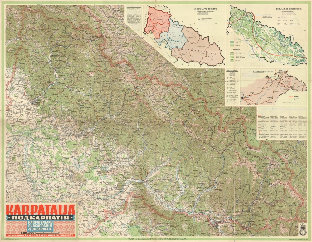
The map depicts the region from Kisvárda to Kjernyicsnij and from Poland to Romania. Towns in Transcarpathia are labeled first in Hungarian, then in Ruthenian in parentheses, and then, possibly, in brackets according to the 1913 Hungarian locality directory. Mountains with elevations are identified throughout. Thick red lines mark the international borders between Transcarpathia and Slovakia, Poland, Romania, and Ukraine. Insets in the upper right illustrate administrative divisions, forests and climate, and roads and railroads between Transcarpathia and Budapest, the capital of Hungary. A key is also included and describes the notations used on the map in Hungarian, Russian, German, Italian, and French. Incredibly, symbols mark tourism offices, suggesting that in 1940 tourists were visiting Transcarpathia even though World War II (1939 - 1945) was raging to the west and north.A Short Modern History of Transcarpathia
Transcarpathia (Kárpátalja in Hungarian) is a region in modern-day eastern Ukraine that borders Hungary, Slovakia, Romania, and a small part of Poland. As a region, Transcarpathia differs from the rest of Ukraine in many respects due to its separate history. Transcarpathia was part of Hungary for over 1,000 years. It was ceded to newly-created Czechoslovakia as part of the 1920 Treaty of Trianon. Under the treaty, Transcarpathia was guaranteed some autonomy, but the government in Prague never granted it. In 1938, after the disastrous Munich Agreement, the southern portion of Transcarpathia was awarded to Hungary as part of the First Vienna Award. The rest of Transcarpathia became an autonomous region of the Second Czechoslovak Republic, which existed for only 169 days. Slovakia declared independence from the Second Czechoslovak Republic on March 14, 1939. Carpatho-Ukraine declared itself an independent republic the following day, March 15, 1939, and is known as the 'one-day republic' because it didn't exist for more than one day. Hungary annexed and invaded Carpatho-Ukraine on March 15, and by March 18, all resistance had been crushed. The Red Army occupied Transcarpathia in October 1944. Czechoslovak President Edvard Beneš signed an agreement to cede the region to the Soviet Union on June 29, 1945, and Transcarpathia was made part of the Ukrainian SSR in July.
Transcarpathia remained under Hungarian control throughout World War II. Tens of thousands were killed, and even more fled to the Soviet Union. Some joined the Czechoslovak Army. After Nazi Germany invaded and occupied Hungary in March 1944, the region's Jewish population was almost entirely deported and very few survived the Holocaust.Publication History and Census
This map was created and published by the Royal Hungarian Institute of Military Cartography (Magyar Királyi Honvéd Térképészeti Intézet) in 1940. We note a single cataloged example in OCLC, which is part of the collection at the Bibliothèque nationale de France. This piece is scarce on the private market.
Cartographer
Magyar Királyi Állami Térképészet (1867 - 1952), translated 'Royal Hungarian State Cartography,' was a Hungarian government map publishing house active the early 20th centuries. The organization can trace its origins to the Austro–Hungarian Compromise of 1867, which gave Hungary marginal independence with the right to establish its own civil cartography - thus issuing tourist maps, school maps, cadastral plans, etc. More detailed topographical cartography remained under Austrian jurisdiction. This changed in 1918, during World War I, when Hungarian military leadership commissioned Colonel Lajos Hajts (1866 - 1933), professor of the Ludovika Military Academy, to lay the framework for a Hungarian State Cartography. This led to the formation on February 4, 1919, of the Hungarian Military Mapping Group (Magyar Katonai Térképező). This organization was based on the Austrian Militärgeographisches Institut model. The name changed in 1922 to Magyar Királyi Katonai Állami Térképészet (Royal Hungarian State Mapping Institute). In 1938, the name again changed, this time to the Magyar Királyi Honvéd Térképészeti Intézet (Royal Hungarian Institute of Military Cartography). The the Honvéd Térképészeti Intézet was folded into the Soviet-style Ministry of Defense in 1952. More by this mapmaker...
Very good. Light wear along original fold lines. Verso repairs to fold separations and at fold intersections. Slight loss at several fold intersections.
OCLC 494965334.