This copy is copyright protected.
Copyright © 2025 Geographicus Rare Antique Maps
Digital Image: 1940 Royal Hungarian Institute of Military Cartography Map of Transcarpathia
Karpatalja-magyar-1940_d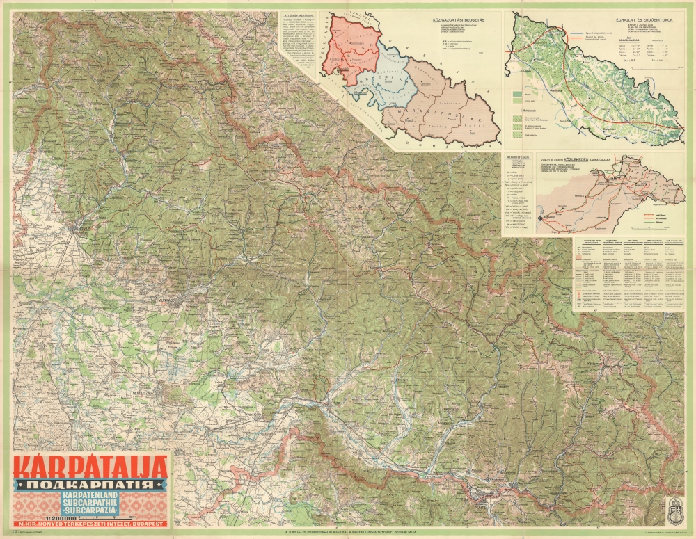


FOR THE ORIGINAL ANTIQUE MAP, WITH HISTORICAL ANALYSIS, CLICK HERE.
Digital Map Information
Geographicus maintains an archive of high-resolution rare map scans. We scan our maps at 300 DPI or higher, with newer images being 600 DPI, (either TIFF or JPEG, depending on when the scan was done) which is most cases in suitable for enlargement and printing.
Delivery
Once you purchase our digital scan service, you will receive a download link via email - usually within seconds. Digital orders are delivered as ZIP files, an industry standard file compression protocol that any computer should be able to unpack. Some of our files are very large, and can take some time to download. Most files are saved into your computer's 'Downloads' folder. All delivery is electronic. No physical product is shipped.
Credit and Scope of Use
You can use your digial image any way you want! Our digital images are unrestricted by copyright and can be used, modified, and published freely. The textual description that accompanies the original antique map is not included in the sale of digital images and remains protected by copyright. That said, we put significant care and effort into scanning and editing these maps, and we’d appreciate a credit when possible. Should you wish to credit us, please use the following credit line:
Courtesy of Geographicus Rare Antique Maps (http://www.geographicus.com).
How Large Can I Print?
In general, at 300 DPI, you should at least be able to double the size of the actual image, more so with our 600 DPI images. So, if the original was 10 x 12 inches, you can print at 20 x 24 inches, without quality loss. If your display requirements can accommodate some loss in image quality, you can make it even larger. That being said, no quality of scan will allow you to blow up at 10 x 12 inch map to wall size without significant quality loss. For more information, it is best consult a printer or reprographics specialist.
Refunds
If the high resolution image you ordered is unavailable, we will fully refund your purchase. Otherwise, digital images scans are a service, not a tangible product, and cannot be returned or refunded once the download link is used.
Magyar Királyi Állami Térképészet (1867 - 1952), translated 'Royal Hungarian State Cartography,' was a Hungarian government map publishing house active the early 20th centuries. The organization can trace its origins to the Austro–Hungarian Compromise of 1867, which gave Hungary marginal independence with the right to establish its own civil cartography - thus issuing tourist maps, school maps, cadastral plans, etc. More detailed topographical cartography remained under Austrian jurisdiction. This changed in 1918, during World War I, when Hungarian military leadership commissioned Colonel Lajos Hajts (1866 - 1933), professor of the Ludovika Military Academy, to lay the framework for a Hungarian State Cartography. This led to the formation on February 4, 1919, of the Hungarian Military Mapping Group (Magyar Katonai Térképező). This organization was based on the Austrian Militärgeographisches Institut model. The name changed in 1922 to Magyar Királyi Katonai Állami Térképészet (Royal Hungarian State Mapping Institute). In 1938, the name again changed, this time to the Magyar Királyi Honvéd Térképészeti Intézet (Royal Hungarian Institute of Military Cartography). The the Honvéd Térképészeti Intézet was folded into the Soviet-style Ministry of Defense in 1952. More by this mapmaker...
Copyright © 2025 Geographicus Rare Antique Maps | Geographicus Rare Antique Maps
This copy is copyright protected.
Copyright © 2025 Geographicus Rare Antique Maps