Digital Image: 1790 Kummer Map of Tibet, Bhutan, and Nepal - a milestone!
Tibet-kummer-1790_d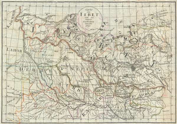

Title
Carte von Tibet nach den neuesten Nachrichten entworfen.
1790 (dated) 12.5 x 18 in (31.75 x 45.72 cm) 1 : 5000000
1790 (dated) 12.5 x 18 in (31.75 x 45.72 cm) 1 : 5000000
Description
FOR THE ORIGINAL ANTIQUE MAP, WITH HISTORICAL ANALYSIS, CLICK HERE.
Digital Map Information
Geographicus maintains an archive of high-resolution rare map scans. We scan our maps at 300 DPI or higher, with newer images being 600 DPI, (either TIFF or JPEG, depending on when the scan was done) which is most cases in suitable for enlargement and printing.
Delivery
Once you purchase our digital scan service, you will receive a download link via email - usually within seconds. Digital orders are delivered as ZIP files, an industry standard file compression protocol that any computer should be able to unpack. Some of our files are very large, and can take some time to download. Most files are saved into your computer's 'Downloads' folder. All delivery is electronic. No physical product is shipped.
Credit and Scope of Use
You can use your digial image any way you want! Our digital images are unrestricted by copyright and can be used, modified, and published freely. The textual description that accompanies the original antique map is not included in the sale of digital images and remains protected by copyright. That said, we put significant care and effort into scanning and editing these maps, and we’d appreciate a credit when possible. Should you wish to credit us, please use the following credit line:
Courtesy of Geographicus Rare Antique Maps (http://www.geographicus.com).
How Large Can I Print?
In general, at 300 DPI, you should at least be able to double the size of the actual image, more so with our 600 DPI images. So, if the original was 10 x 12 inches, you can print at 20 x 24 inches, without quality loss. If your display requirements can accommodate some loss in image quality, you can make it even larger. That being said, no quality of scan will allow you to blow up at 10 x 12 inch map to wall size without significant quality loss. For more information, it is best consult a printer or reprographics specialist.
Refunds
If the high resolution image you ordered is unavailable, we will fully refund your purchase. Otherwise, digital images scans are a service, not a tangible product, and cannot be returned or refunded once the download link is used.
Cartographer
Paul Gotthelf Kummer (December 29, 1750 - February 25, 1835) was a Leipzig based German bookseller, printer, engraver, and publisher. Kummer was born in Mutzschen, near Freiberg, the son of pastor Georg Friedrich Kummer (1708-1771) and Christiana Elisabeth. He apprenticed in the book trade under Johann Samuel Heinsius the Younger (1734-1807) and afterwards worked with the bookseller Johann Gottfried Dyck in Leipzig. He opened his own Leipzig commission bookshop in 1776 and, meeting with some success by 1777, took over the Saalbach Publishing House. By 1800 he was well established and married Sophie Cichorius (1800), sister of the well-respected professor of anatomy in Dorpat Ludwig Emil Cichorius (1740-1829). Around 1813 he expanded again, acquiring the Stahl'schen Bookstore in Jena. Kummer was socially popular in academic circles and was regarded as 'honest and true-hearted, at times a little primitive.' and his wife had 11 children, of which Eduard Kummer inherited his bookstore, which he ran until his death in 1860. More by this mapmaker...
Source
Forster J. R., and Sprengel, Matthias C., Neue Beiträge zur Völker- und Länderkunde, (Leipzig) 1790.
References
OCLC 646404224. Harvard University, HOLLIS, 012523074.