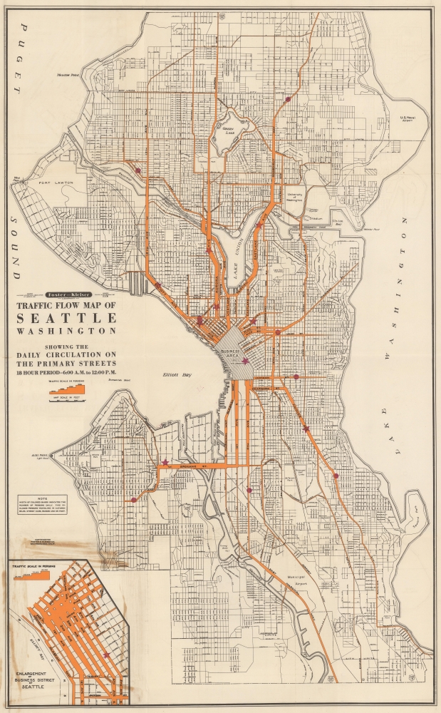
A splendid c. 1952 Foster and Kleiner infographic map of Seattle, Washington, illustrating traffic flow. Kleiner and Foster, an outdoor advertising firm, created this map to study traffic patterns and determine premium billboard locations.
A Closer Look
The map depicts Seattle from E 117th Street south to W. Leo Street and from Puget Sound to Lake Washington. Bright orange highlights main traffic arteries: Roosevelt Way, Madison Street, East Lake Avenue, Aurora Avenue, East Marginal Way, Rainier Avenue, West Spokane Street, 1st Avenue S., and 4th Avenue South. These streets vary in width, which illustrates the number of persons that travel along each road over an average 18-hour day - the widest seeing some 60,000 people. An inset in the lower left corner focuses on Seattle's business district, where some streets exhibit a traffic flow of over 100,000 people daily.A Company Sales Document?
Red stars and dots appear at several locations across the map. While no key explains these, we suspect they represent Foster and Kleiner billboard locations. Foster and Kleiner sold outdoor advertising space, which explains why they created a traffic flow map. This information would allow the firm to place billboards at strategic locations based on traffic flow. The map may have been part of a Foster and Kleiner sales pitch to prospective clients or used internally.Publication History and Census
This map was created and published by Foster and Kleiner c. 1952. The map appears in the 1953 Library of Congress Catalog of Copyright Entries. Five examples of a map bearing this title are cataloged in OCLC and are dated 1931 (University of Kansas), 1948 (University of Washington, Seattle Public Library, Stanford University), and 1952 (Library of Congress).
Cartographer
Foster and Kleiser (1901 - Present) is an American outdoor advertising firm. The company was founded in 1901 by Walter Foster (September 30, 1871 - January 13, 1944) and George Kleiser (June 25, 1874 - November 30, 1952) in Portland, Oregon and Seattle, Washington, and incorporated in 1902. The company steadily grows, with Foster and Kleiser acquiring smaller businesses throughout Washington, Oregon, and California. The W.R. Grace Company bought Foster and Kleiser in 1952 but retained the name. Metropolitan Broadcasting purchased the company in 1959 but again retained the original name. The Patrick Media Company bought the Foster and Kleiser brand in 1986 and changed the name to the Patrick Media Group. Karl Eller and Partners purchased the company in 1995, changed the name to Eller Media Company, which became a subsidiary of Clear Channel Communications in 1997, and changed the name to Clear Channel Outdoor in 2001, and still operates under that name. More by this mapmaker...
Good. Light wear along original fold lines. Slight loss at a fold intersection. Old adhesive on 1 panel on verso.
Library of Congress, G4284.S4P2 1952 .F6. OCLC 53956782.