This copy is copyright protected.
Copyright © 2025 Geographicus Rare Antique Maps
Digital Image: 1952 Foster and Kleiser Infographic Map of Seattle, Washington: Traffic Flow
TrafficFlowSeattle-fosterkleiser-1952_d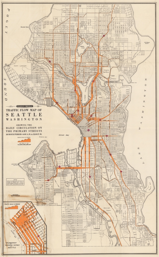


FOR THE ORIGINAL ANTIQUE MAP, WITH HISTORICAL ANALYSIS, CLICK HERE.
Digital Map Information
Geographicus maintains an archive of high-resolution rare map scans. We scan our maps at 300 DPI or higher, with newer images being 600 DPI, (either TIFF or JPEG, depending on when the scan was done) which is most cases in suitable for enlargement and printing.
Delivery
Once you purchase our digital scan service, you will receive a download link via email - usually within seconds. Digital orders are delivered as ZIP files, an industry standard file compression protocol that any computer should be able to unpack. Some of our files are very large, and can take some time to download. Most files are saved into your computer's 'Downloads' folder. All delivery is electronic. No physical product is shipped.
Credit and Scope of Use
You can use your digial image any way you want! Our digital images are unrestricted by copyright and can be used, modified, and published freely. The textual description that accompanies the original antique map is not included in the sale of digital images and remains protected by copyright. That said, we put significant care and effort into scanning and editing these maps, and we’d appreciate a credit when possible. Should you wish to credit us, please use the following credit line:
Courtesy of Geographicus Rare Antique Maps (http://www.geographicus.com).
How Large Can I Print?
In general, at 300 DPI, you should at least be able to double the size of the actual image, more so with our 600 DPI images. So, if the original was 10 x 12 inches, you can print at 20 x 24 inches, without quality loss. If your display requirements can accommodate some loss in image quality, you can make it even larger. That being said, no quality of scan will allow you to blow up at 10 x 12 inch map to wall size without significant quality loss. For more information, it is best consult a printer or reprographics specialist.
Refunds
If the high resolution image you ordered is unavailable, we will fully refund your purchase. Otherwise, digital images scans are a service, not a tangible product, and cannot be returned or refunded once the download link is used.
Foster and Kleiser (1901 - Present) is an American outdoor advertising firm. The company was founded in 1901 by Walter Foster (September 30, 1871 - January 13, 1944) and George Kleiser (June 25, 1874 - November 30, 1952) in Portland, Oregon and Seattle, Washington, and incorporated in 1902. The company steadily grows, with Foster and Kleiser acquiring smaller businesses throughout Washington, Oregon, and California. The W.R. Grace Company bought Foster and Kleiser in 1952 but retained the name. Metropolitan Broadcasting purchased the company in 1959 but again retained the original name. The Patrick Media Company bought the Foster and Kleiser brand in 1986 and changed the name to the Patrick Media Group. Karl Eller and Partners purchased the company in 1995, changed the name to Eller Media Company, which became a subsidiary of Clear Channel Communications in 1997, and changed the name to Clear Channel Outdoor in 2001, and still operates under that name. More by this mapmaker...
Copyright © 2025 Geographicus Rare Antique Maps | Geographicus Rare Antique Maps
This copy is copyright protected.
Copyright © 2025 Geographicus Rare Antique Maps