
This copy is copyright protected.
Copyright © 2025 Geographicus Rare Antique Maps
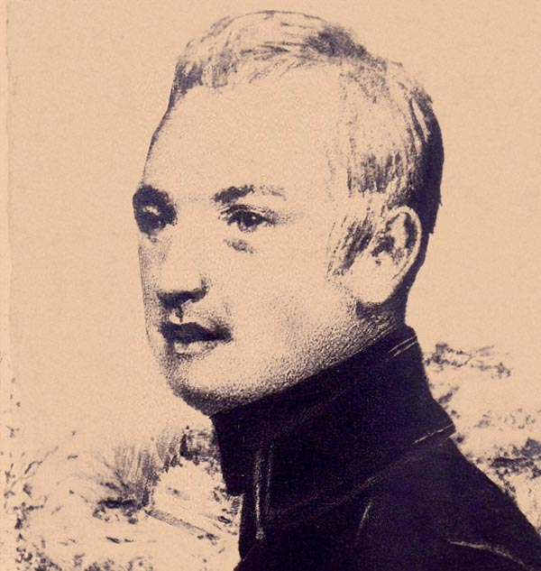
Thomas Hannaford Hurd (January 30, 1747 - April 29, 1823) was a hydrographer and Royal Navy officer who rose to become Hydrographer of the Navy in 1808, succeeding Alexander Dalrymple, who had been the first holder of that office. Hurd was born in Plymouth, an ideal location for a future mariner. He joined the Royal Navy in 1768 and served along the coasts North America, gaining his first exposure to hydrographic methods, learning from Samuel Holland (1728 - 1801) while both were aboard the HMS Canceaux. Holland and Hurd were part of an extensive surveying project overseen by J.F.W. DesBarres (1721 - 1824) combining both land surveys and hydrography along the North American coast; the result of their efforts was the seminal work, the Atlantic Neptune, the most important maritime atlas of its day (first published in 1777). Hurd saw extensive action as an officer (lieutenant) under Lord Howe during the Anglo-French War (1778 - 1783), a global conflict that was largely an ancillary to the American War of Independence. At the conclusion of the war, Howe recommended Hurd as surveyor-general of Cape Breton, a post he held for only one year before being dismissed by the same Desbarres he had previously worked for, who was at the time the Lieutenant-Governor of Cape Breton Colony. Between 1789 and 1797, Hurd was tasked with producing a survey of the Atlantic archipelago Bermuda, which had maintained some English settlers and an ambivalent relationship with England itself, being more economically connected with the American colonies, and later the United States. Hurd's resulting highly-detailed survey of Bermuda demonstrated its advantages as a naval station, and his subsequent advocacy of a strong British presence there were instrumental in determining the later history of the archipelago, with it becoming a major British naval station in the early 19th century. During and after his work on Bermuda, Hurd was promoted through the ranks of the Royal Navy, to commander and then post-captain. In 1804, he undertook a survey of Brest and the nearby portions of the French coast - crucial information given the area's proximity to England and the persistent British-French tensions at the time. In 1808, due to his surveying experience, Hurd succeeded Alexander Dalrymple as Hydrographer of the Navy upon the latter's death. As Dalrymple had been the inaugural holder of the office, the post was still in the process of formation and was influenced by complex politics between the Hydrographer, based in the Hydrographic Office, and the Admiralty Board, which oversaw the new office. Still, the Hydrographic Office was a relatively small and experimental corner in the wide universe of expenditures and issues overseen by the Admiralty Board, providing the Hydrographers with a degree of autonomy. According to research by Adrian Webb, who has written a biography of Hurd covering his fifteen years of work as Hydrographer, Hurd was an effective manager and greatly improved the quality and consistency of the office's work. He was also adept at navigating the politics of the Admiralty and befriended the powerful Robert Dundas, 2nd Viscount Melville. This allowed him, for example, to gain promotions for skilled surveyors under his purview, thus improving the office's output and in turn making it more important as a source of critical information for the Admiralty writ large. Perhaps most significantly, Hurd was a proponent of sharing hydrographical data with hydrographers from other countries, even suspect ones like France, allowing for rapid dissemination of the best information across borders. He also made the charts his office produced available to the public, saving countless merchant ships from damage or sinking as a result of incomplete or out-of-date hydrographical charts. Hurd also served as the Superintendent of Chronometers and a Commissioner on the Board of Longitude during the period when chronometers became the preferred method for determining longitude (as opposed to astronomical observations).
Copyright © 2025 Geographicus Rare Antique Maps | Geographicus Rare Antique Maps
This copy is copyright protected.
Copyright © 2025 Geographicus Rare Antique Maps